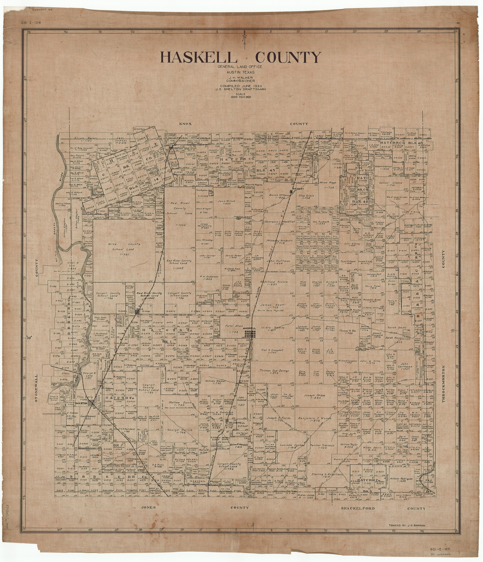
Haskell County
RM-3-104
-
Map/Doc
1852
-
Collection
General Map Collection
-
Object Dates
1933 (Creation Date)
-
People and Organizations
Texas General Land Office (Publisher)
John E. Shelton Jr. (Draftsman)
J.H. Walker (GLO Commissioner)
John E. Shelton Jr. (Compiler)
-
Counties
Haskell
-
Subjects
County
-
Height x Width
45.8 x 39.4 inches
116.3 x 100.1 cm
-
Comments
Traced by J. O. Barrow.
Part of: General Map Collection
Flight Mission No. BRA-6M, Frame 148, Jefferson County

Print $20.00
- Digital $50.00
Flight Mission No. BRA-6M, Frame 148, Jefferson County
1953
Size 18.5 x 22.4 inches
Map/Doc 85449
Young County Working Sketch Graphic Index

Print $20.00
- Digital $50.00
Young County Working Sketch Graphic Index
1941
Size 44.1 x 38.4 inches
Map/Doc 76748
Gaines County Rolled Sketch 14B

Print $40.00
- Digital $50.00
Gaines County Rolled Sketch 14B
1940
Size 142.9 x 24.0 inches
Map/Doc 9032
Gulf Intracoastal Waterway - Aransas Bay to Corpus Christi Bay - Modified Route Main Channel

Print $20.00
- Digital $50.00
Gulf Intracoastal Waterway - Aransas Bay to Corpus Christi Bay - Modified Route Main Channel
Size 30.9 x 41.9 inches
Map/Doc 61904
Map of Hill County

Print $40.00
- Digital $50.00
Map of Hill County
1884
Size 80.0 x 36.8 inches
Map/Doc 93378
Panola County Working Sketch 27

Print $20.00
- Digital $50.00
Panola County Working Sketch 27
1956
Map/Doc 71436
Loving County Sketch File 5

Print $10.00
- Digital $50.00
Loving County Sketch File 5
Size 9.7 x 8.3 inches
Map/Doc 30412
Harris County NRC Article 33.136 Location Key Sheet

Print $20.00
- Digital $50.00
Harris County NRC Article 33.136 Location Key Sheet
1995
Size 27.0 x 21.8 inches
Map/Doc 77027
Reagan County Rolled Sketch 1

Print $20.00
- Digital $50.00
Reagan County Rolled Sketch 1
Size 20.1 x 29.5 inches
Map/Doc 7432
Jim Hogg Co. / Brooks Co.

Print $20.00
- Digital $50.00
Jim Hogg Co. / Brooks Co.
1912
Size 33.0 x 43.6 inches
Map/Doc 4894
Bastrop County Rolled Sketch 3

Print $20.00
- Digital $50.00
Bastrop County Rolled Sketch 3
Size 32.0 x 40.2 inches
Map/Doc 8441
Texas Coast, No. 17

Print $20.00
- Digital $50.00
Texas Coast, No. 17
Size 18.3 x 27.6 inches
Map/Doc 72712
You may also like
Bosque County Working Sketch 19

Print $20.00
- Digital $50.00
Bosque County Working Sketch 19
1976
Size 28.7 x 27.7 inches
Map/Doc 67452
Harris County Working Sketch 6

Print $20.00
- Digital $50.00
Harris County Working Sketch 6
1905
Size 20.4 x 12.1 inches
Map/Doc 65898
Working Sketch in Hutchinson County

Print $20.00
- Digital $50.00
Working Sketch in Hutchinson County
1922
Size 16.9 x 13.6 inches
Map/Doc 91251
Culberson County Rolled Sketch 68

Print $20.00
- Digital $50.00
Culberson County Rolled Sketch 68
1997
Size 32.0 x 32.9 inches
Map/Doc 76402
Flight Mission No. DCL-6C, Frame 48, Kenedy County

Print $20.00
- Digital $50.00
Flight Mission No. DCL-6C, Frame 48, Kenedy County
1943
Size 18.7 x 22.3 inches
Map/Doc 85890
Hidalgo County Sketch File 2

Print $14.00
- Digital $50.00
Hidalgo County Sketch File 2
1877
Size 10.1 x 8.1 inches
Map/Doc 26394
Fort Bend County Sketch File 33

Print $20.00
- Digital $50.00
Fort Bend County Sketch File 33
1889
Size 23.6 x 24.5 inches
Map/Doc 11513

Carte de la Louisiane et du Cours du Mississipi

Print $20.00
Carte de la Louisiane et du Cours du Mississipi
1718
Size 16.6 x 21.8 inches
Map/Doc 89216
Oldham County Boundary File 1c

Print $48.00
- Digital $50.00
Oldham County Boundary File 1c
Size 14.0 x 8.4 inches
Map/Doc 57753
Atascosa County

Print $20.00
- Digital $50.00
Atascosa County
1862
Size 29.8 x 25.2 inches
Map/Doc 3248
[Galveston, Harrisburg & San Antonio Railroad from Cuero to Stockdale]
![64191, [Galveston, Harrisburg & San Antonio Railroad from Cuero to Stockdale], General Map Collection](https://historictexasmaps.com/wmedia_w700/maps/64191.tif.jpg)
Print $20.00
- Digital $50.00
[Galveston, Harrisburg & San Antonio Railroad from Cuero to Stockdale]
1907
Size 14.2 x 34.2 inches
Map/Doc 64191