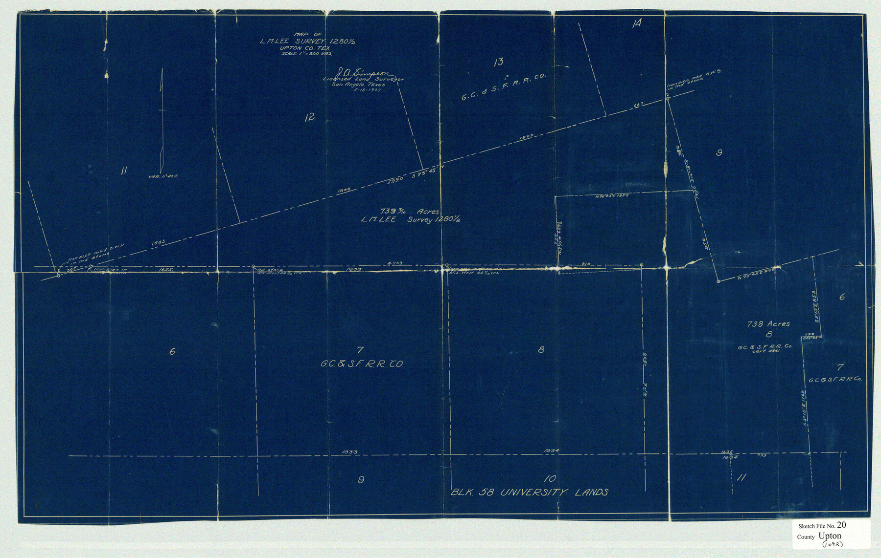
Upton County Sketch File 20
Map of L. M. Lee Survey 1280 1/2 Upton Co., Tex.
-
Map/Doc
12516
-
Collection
General Map Collection
-
Object Dates
1927/5/18 (Creation Date)
1927/10/15 (File Date)
1927/5/18 (Creation Date)
-
People and Organizations
J.A. Simpson (Surveyor/Engineer)
-
Counties
Upton
-
Subjects
Surveying Sketch File
-
Height x Width
18.5 x 29.2 inches
47.0 x 74.2 cm
-
Medium
blueprint/diazo
Part of: General Map Collection
Plan of the City of Austin

Print $40.00
- Digital $50.00
Plan of the City of Austin
1840
Size 57.3 x 42.0 inches
Map/Doc 2179
Bexar County Working Sketch Graphic Index

Print $20.00
- Digital $50.00
Bexar County Working Sketch Graphic Index
1932
Size 47.9 x 42.6 inches
Map/Doc 76466
PSL Field Notes for Block B9 in Ector and Winkler Counties, Block B13 in Ector, Ward, and Winkler Counties, and Blocks A55, A56, A57, B1, B2, B3, B5, B6, B7, B10, B11, and B12 in Winkler County

PSL Field Notes for Block B9 in Ector and Winkler Counties, Block B13 in Ector, Ward, and Winkler Counties, and Blocks A55, A56, A57, B1, B2, B3, B5, B6, B7, B10, B11, and B12 in Winkler County
Map/Doc 81676
Sketch of State University Lands and Connections in El Paso Co.

Print $20.00
- Digital $50.00
Sketch of State University Lands and Connections in El Paso Co.
1900
Size 33.1 x 32.4 inches
Map/Doc 2427
Blanco County Working Sketch 20

Print $20.00
- Digital $50.00
Blanco County Working Sketch 20
1960
Size 27.3 x 36.4 inches
Map/Doc 67380
Van Zandt County Sketch File 28

Print $4.00
- Digital $50.00
Van Zandt County Sketch File 28
1859
Size 12.5 x 8.2 inches
Map/Doc 39451
Aransas County NRC Article 33.136 Sketch 2

Print $26.00
- Digital $50.00
Aransas County NRC Article 33.136 Sketch 2
2001
Size 18.6 x 24.2 inches
Map/Doc 61643
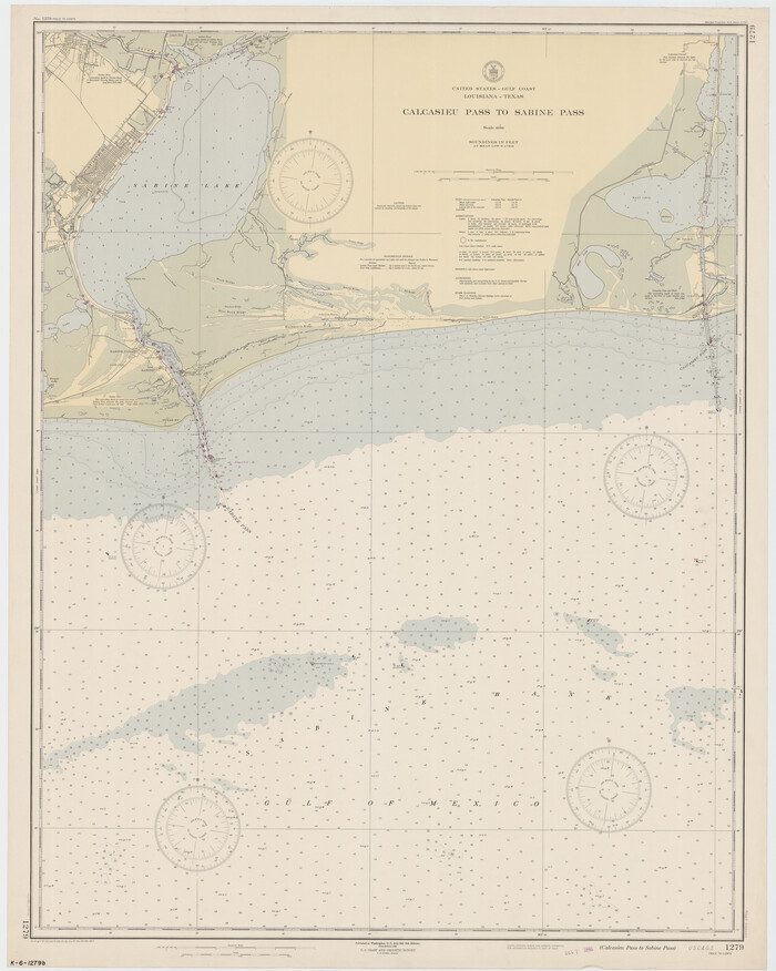
Calcasieu Pass to Sabine Pass
Print $20.00
- Digital $50.00
Calcasieu Pass to Sabine Pass
1946
Size 44.7 x 35.7 inches
Map/Doc 69806
Presidio County

Print $40.00
- Digital $50.00
Presidio County
1875
Size 98.1 x 58.7 inches
Map/Doc 16792
Calhoun County Working Sketch 6

Print $20.00
- Digital $50.00
Calhoun County Working Sketch 6
1943
Size 20.8 x 24.1 inches
Map/Doc 67822
Flight Mission No. DQN-1K, Frame 142, Calhoun County

Print $20.00
- Digital $50.00
Flight Mission No. DQN-1K, Frame 142, Calhoun County
1953
Size 18.8 x 22.3 inches
Map/Doc 84205
Fractional Township No. 7 South Range No. 6 West of the Indian Meridian, Indian Territory

Print $20.00
- Digital $50.00
Fractional Township No. 7 South Range No. 6 West of the Indian Meridian, Indian Territory
1898
Size 19.2 x 24.2 inches
Map/Doc 75188
You may also like
Map of Atascosa Co.

Print $40.00
- Digital $50.00
Map of Atascosa Co.
1894
Size 48.3 x 46.6 inches
Map/Doc 4877
Andrews County Sketch File 4

Print $40.00
- Digital $50.00
Andrews County Sketch File 4
1930
Size 18.5 x 24.2 inches
Map/Doc 10809
Lamb County Sketch File 17

Print $20.00
- Digital $50.00
Lamb County Sketch File 17
1940
Size 25.4 x 12.3 inches
Map/Doc 11973
The Republic County of Rusk. December 29, 1845

Print $20.00
The Republic County of Rusk. December 29, 1845
2020
Size 19.1 x 21.7 inches
Map/Doc 96268
[Texas Boundary Line]
![92081, [Texas Boundary Line], Twichell Survey Records](https://historictexasmaps.com/wmedia_w700/maps/92081-1.tif.jpg)
Print $20.00
- Digital $50.00
[Texas Boundary Line]
Size 21.2 x 12.4 inches
Map/Doc 92081
Potter County Sketch File 7

Print $20.00
- Digital $50.00
Potter County Sketch File 7
Size 23.2 x 18.0 inches
Map/Doc 12197
Atascosa County Working Sketch 31

Print $20.00
- Digital $50.00
Atascosa County Working Sketch 31
1981
Size 21.4 x 16.6 inches
Map/Doc 67227
Terry County Rolled Sketch 9

Print $20.00
- Digital $50.00
Terry County Rolled Sketch 9
Size 23.8 x 23.9 inches
Map/Doc 7983
Exeter and Wilson Empresario Colony. September 23, 1828

Print $20.00
Exeter and Wilson Empresario Colony. September 23, 1828
2020
Size 15.5 x 21.7 inches
Map/Doc 95994
Runnels County Working Sketch 35b

Print $20.00
- Digital $50.00
Runnels County Working Sketch 35b
1981
Size 36.0 x 38.6 inches
Map/Doc 63634
Map of Zavalla County

Print $20.00
- Digital $50.00
Map of Zavalla County
1862
Size 24.2 x 20.5 inches
Map/Doc 4180
Angelina County Sketch File 30

Print $40.00
- Digital $50.00
Angelina County Sketch File 30
1920
Size 24.5 x 32.7 inches
Map/Doc 10818