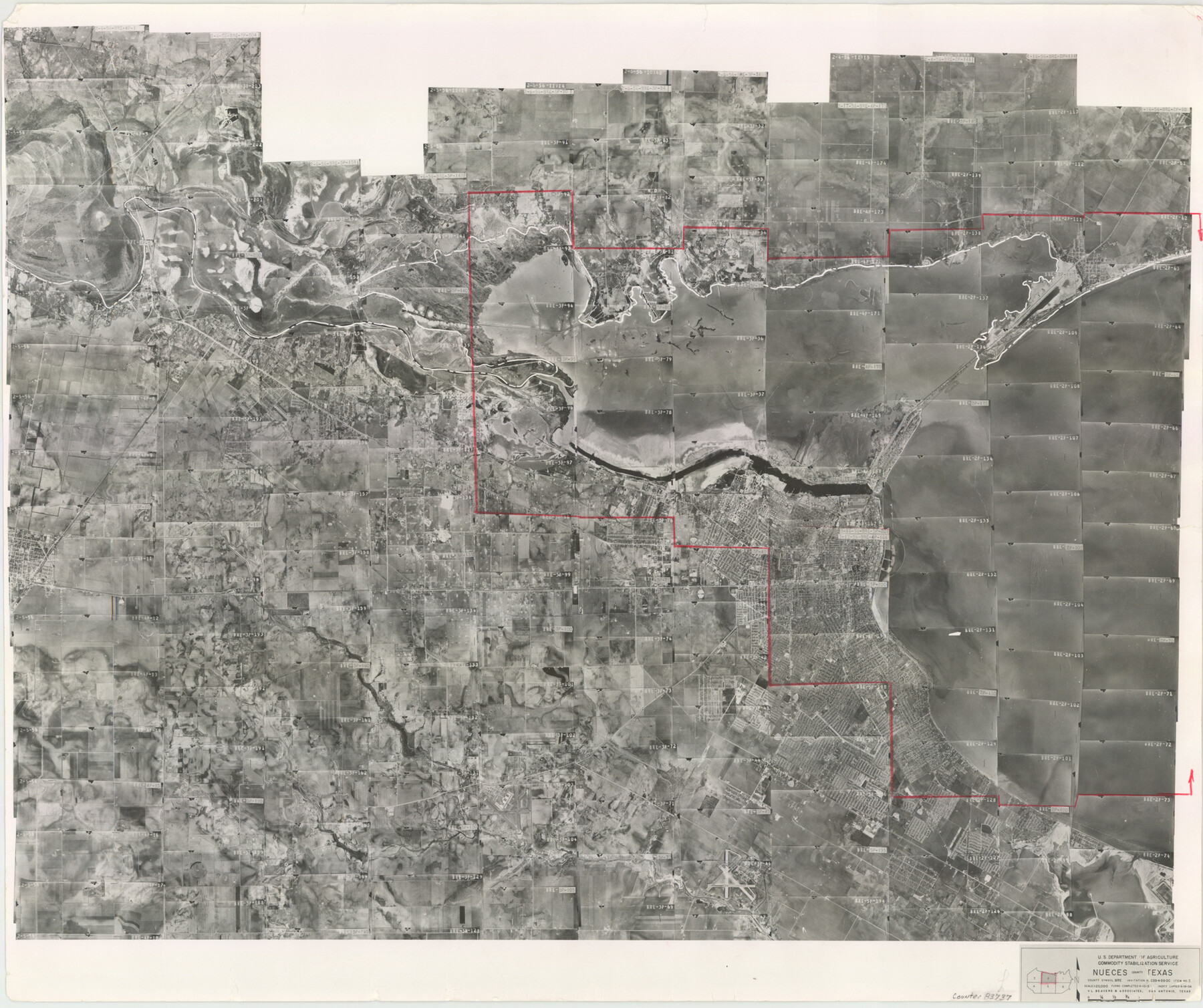
Nueces County Aerial Photograph Index Sheet 2
Nueces County Aerial Photograph Index 2
-
Map/Doc
83737
-
Collection
General Map Collection
-
Object Dates
1956/4/19 (Creation Date)
-
People and Organizations
U. S. Department of Agriculture (Publisher)
-
Counties
Nueces
-
Subjects
Aerial Photograph
-
Height x Width
19.5 x 23.3 inches
49.5 x 59.2 cm
-
Comments
Flying completed April 10, 1956 by V. L. Beavers and Associates of San Antonio, Texas.
Part of: General Map Collection
Map showing survey for proposed ship channel from Brownsville to Brazos Santiago Pass

Print $20.00
- Digital $50.00
Map showing survey for proposed ship channel from Brownsville to Brazos Santiago Pass
1912
Size 18.1 x 28.0 inches
Map/Doc 72899
Houston Ship Channel, Alexander Island to Carpenter Bayou

Print $20.00
- Digital $50.00
Houston Ship Channel, Alexander Island to Carpenter Bayou
1973
Size 35.2 x 46.9 inches
Map/Doc 69910
Uvalde County Working Sketch 49

Print $20.00
- Digital $50.00
Uvalde County Working Sketch 49
1980
Size 35.4 x 44.7 inches
Map/Doc 72119
Mitchell County Boundary File 66c

Print $19.00
- Digital $50.00
Mitchell County Boundary File 66c
Size 12.7 x 8.3 inches
Map/Doc 57390
Flight Mission No. DCL-7C, Frame 28, Kenedy County

Print $20.00
- Digital $50.00
Flight Mission No. DCL-7C, Frame 28, Kenedy County
1943
Size 15.4 x 15.4 inches
Map/Doc 86020
Flight Mission No. BRA-16M, Frame 101, Jefferson County

Print $20.00
- Digital $50.00
Flight Mission No. BRA-16M, Frame 101, Jefferson County
1953
Size 18.6 x 22.4 inches
Map/Doc 85713
Orange County Sketch File 9b

Print $22.00
- Digital $50.00
Orange County Sketch File 9b
1873
Size 14.6 x 12.6 inches
Map/Doc 33315
Harris County Working Sketch 24

Print $20.00
- Digital $50.00
Harris County Working Sketch 24
1928
Size 29.3 x 15.9 inches
Map/Doc 65916
Flight Mission No. CGI-1N, Frame 172, Cameron County

Print $20.00
- Digital $50.00
Flight Mission No. CGI-1N, Frame 172, Cameron County
1955
Size 18.5 x 22.2 inches
Map/Doc 84507
Pecos County Working Sketch 16

Print $20.00
- Digital $50.00
Pecos County Working Sketch 16
1915
Size 23.6 x 17.0 inches
Map/Doc 71486
Chambers County Sketch File 26

Print $20.00
- Digital $50.00
Chambers County Sketch File 26
1934
Size 19.6 x 24.6 inches
Map/Doc 11066
Calhoun County Rolled Sketch 9

Print $20.00
- Digital $50.00
Calhoun County Rolled Sketch 9
Size 24.4 x 38.7 inches
Map/Doc 5365
You may also like
Refugio County Boundary File 3a

Print $28.00
- Digital $50.00
Refugio County Boundary File 3a
Size 14.1 x 8.8 inches
Map/Doc 58246
Maverick County Sketch File 15

Print $8.00
- Digital $50.00
Maverick County Sketch File 15
Size 14.2 x 8.6 inches
Map/Doc 31113
Bowie County Sketch File 6c

Print $40.00
- Digital $50.00
Bowie County Sketch File 6c
1927
Size 20.1 x 16.1 inches
Map/Doc 10942
Red River County Working Sketch 4

Print $20.00
- Digital $50.00
Red River County Working Sketch 4
1919
Size 19.7 x 18.8 inches
Map/Doc 71987
Sketch K Showing the Progress of the Survey of the Columbia River, Oregon

Print $20.00
- Digital $50.00
Sketch K Showing the Progress of the Survey of the Columbia River, Oregon
1852
Size 9.8 x 12.7 inches
Map/Doc 97237
Motley County Working Sketch Graphic Index

Print $20.00
- Digital $50.00
Motley County Working Sketch Graphic Index
1966
Size 42.3 x 33.3 inches
Map/Doc 76650
Blanco County Rolled Sketch 15

Print $20.00
- Digital $50.00
Blanco County Rolled Sketch 15
Size 12.9 x 13.7 inches
Map/Doc 5151
Austin County Sketch File 11

Print $8.00
- Digital $50.00
Austin County Sketch File 11
1895
Size 11.1 x 8.6 inches
Map/Doc 13877
Railroad Track Map, H&TCRRCo., Falls County, Texas

Print $4.00
- Digital $50.00
Railroad Track Map, H&TCRRCo., Falls County, Texas
1918
Size 11.6 x 18.3 inches
Map/Doc 62855
Lamar County Working Sketch 8

Print $20.00
- Digital $50.00
Lamar County Working Sketch 8
1969
Size 39.3 x 31.6 inches
Map/Doc 70269
Brazoria County Working Sketch 6

Print $20.00
- Digital $50.00
Brazoria County Working Sketch 6
1922
Size 16.8 x 24.0 inches
Map/Doc 67491
North Part of El Paso Co.

Print $20.00
- Digital $50.00
North Part of El Paso Co.
1977
Size 35.7 x 46.3 inches
Map/Doc 73141