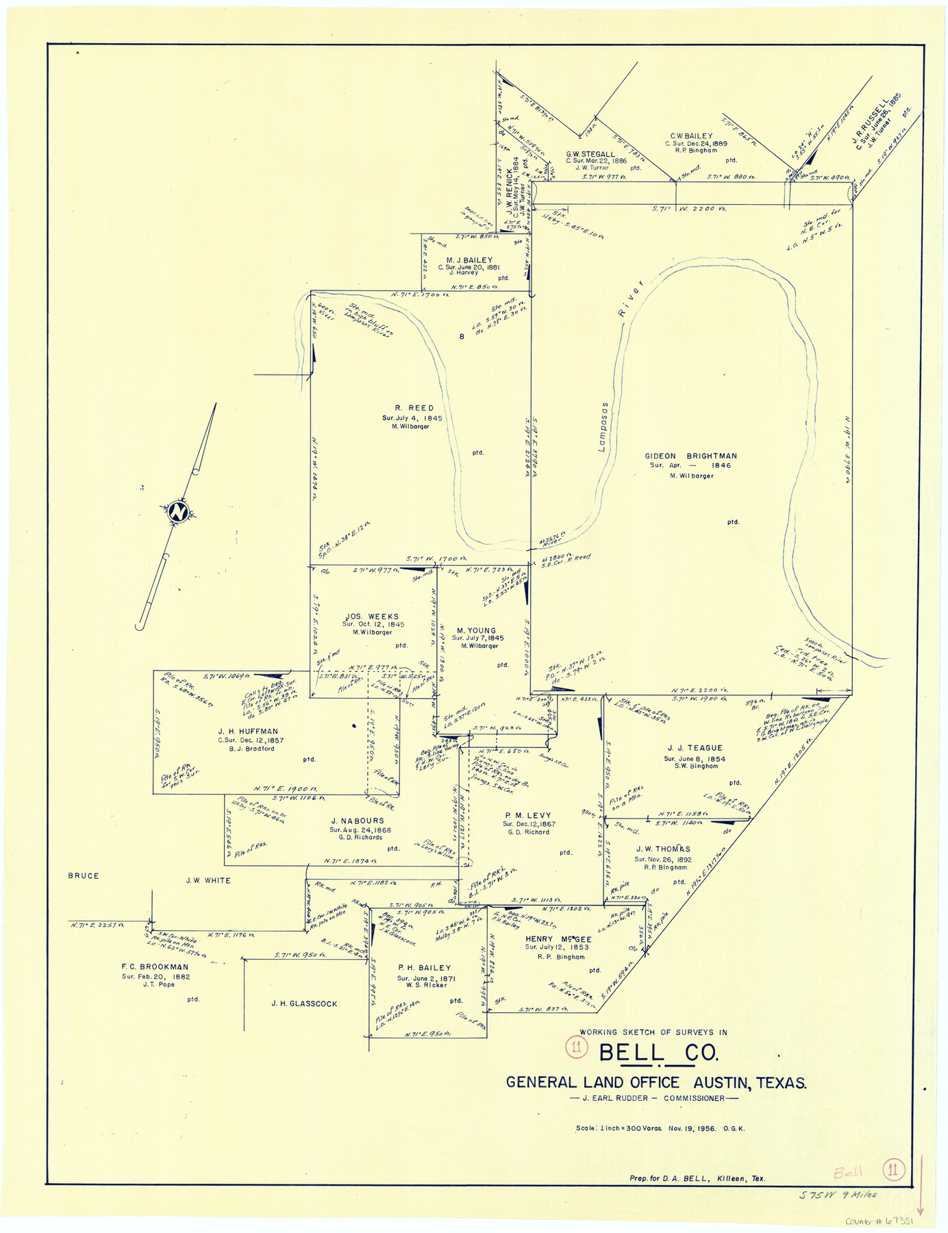
Bell County Working Sketch 11
-
Map/Doc
67351
-
Collection
General Map Collection
-
Object Dates
11/19/1956 (Creation Date)
-
People and Organizations
J. Earl Rudder (GLO Commissioner)
Otto G. Kurio (Draftsman)
-
Counties
Bell
-
Subjects
Surveying Working Sketch
-
Height x Width
31.8 x 24.4 inches
80.8 x 62.0 cm
-
Scale
1" = 300 varas
-
Comments
Surveys located about nine miles South 75 degrees West of Belton, Texas.
Part of: General Map Collection
Map of section no. 11 of a survey of Padre Island made for the Office of the Attorney General of the State of Texas

Print $40.00
- Digital $50.00
Map of section no. 11 of a survey of Padre Island made for the Office of the Attorney General of the State of Texas
1941
Size 60.1 x 40.4 inches
Map/Doc 2267
Falls County Sketch File 22

Print $10.00
- Digital $50.00
Falls County Sketch File 22
1921
Size 8.3 x 5.4 inches
Map/Doc 22423

Clay County Working Sketch 1

Print $20.00
- Digital $50.00
Clay County Working Sketch 1
Size 30.7 x 29.3 inches
Map/Doc 68024
[Galveston, Harrisburg & San Antonio Railroad from Cuero to Stockdale]
![64190, [Galveston, Harrisburg & San Antonio Railroad from Cuero to Stockdale], General Map Collection](https://historictexasmaps.com/wmedia_w700/maps/64190.tif.jpg)
Print $20.00
- Digital $50.00
[Galveston, Harrisburg & San Antonio Railroad from Cuero to Stockdale]
1907
Size 13.7 x 34.0 inches
Map/Doc 64190
Montgomery County Working Sketch 11

Print $20.00
- Digital $50.00
Montgomery County Working Sketch 11
1933
Size 25.2 x 17.7 inches
Map/Doc 71118
Hunt County Boundary File 10

Print $14.00
- Digital $50.00
Hunt County Boundary File 10
Size 9.2 x 14.9 inches
Map/Doc 55255
Burnet County Sketch File 32

Print $4.00
- Digital $50.00
Burnet County Sketch File 32
1894
Size 8.0 x 9.5 inches
Map/Doc 16750
Lampasas County Working Sketch 6

Print $20.00
- Digital $50.00
Lampasas County Working Sketch 6
1950
Size 29.5 x 20.6 inches
Map/Doc 70283
Calhoun County Rolled Sketch 11

Print $20.00
- Digital $50.00
Calhoun County Rolled Sketch 11
1942
Size 12.8 x 41.9 inches
Map/Doc 5368
Medina County Rolled Sketch 8

Print $20.00
- Digital $50.00
Medina County Rolled Sketch 8
1975
Size 24.8 x 25.5 inches
Map/Doc 6742
Flight Mission No. DQN-1K, Frame 135, Calhoun County

Print $20.00
- Digital $50.00
Flight Mission No. DQN-1K, Frame 135, Calhoun County
1953
Size 18.3 x 22.4 inches
Map/Doc 84198
You may also like
The Republic County of Robertson. January 29, 1842

Print $20.00
The Republic County of Robertson. January 29, 1842
2020
Size 16.9 x 21.7 inches
Map/Doc 96262
Stonewall County Sketch File 19

Print $20.00
- Digital $50.00
Stonewall County Sketch File 19
Size 33.2 x 33.6 inches
Map/Doc 10392
Mexico and Guatimala

Print $20.00
- Digital $50.00
Mexico and Guatimala
1828
Size 9.9 x 12.4 inches
Map/Doc 97276
Van Zandt County Sketch File 42

Print $4.00
- Digital $50.00
Van Zandt County Sketch File 42
1874
Size 10.0 x 8.1 inches
Map/Doc 39495
Flight Mission No. DAH-17M, Frame 27, Orange County

Print $20.00
- Digital $50.00
Flight Mission No. DAH-17M, Frame 27, Orange County
1953
Size 18.6 x 22.3 inches
Map/Doc 86890
Ellis County Boundary File 67 1/2

Print $24.00
- Digital $50.00
Ellis County Boundary File 67 1/2
Size 9.0 x 4.1 inches
Map/Doc 53003
Gillespie County Sketch File 7a

Print $4.00
- Digital $50.00
Gillespie County Sketch File 7a
Size 3.5 x 8.1 inches
Map/Doc 24143
Working Sketch in Stephens County

Print $20.00
- Digital $50.00
Working Sketch in Stephens County
1919
Size 11.1 x 20.6 inches
Map/Doc 91903
Brazoria County Working Sketch 33

Print $20.00
- Digital $50.00
Brazoria County Working Sketch 33
1980
Size 29.6 x 35.6 inches
Map/Doc 67518
Kerr County Sketch File 1b

Print $2.00
- Digital $50.00
Kerr County Sketch File 1b
Size 8.1 x 10.2 inches
Map/Doc 28850
Wilbarger County Sketch File 8

Print $4.00
- Digital $50.00
Wilbarger County Sketch File 8
1885
Size 14.2 x 8.6 inches
Map/Doc 40179
Flight Mission No. DCL-7C, Frame 70, Kenedy County

Print $20.00
- Digital $50.00
Flight Mission No. DCL-7C, Frame 70, Kenedy County
1943
Size 15.4 x 15.3 inches
Map/Doc 86056