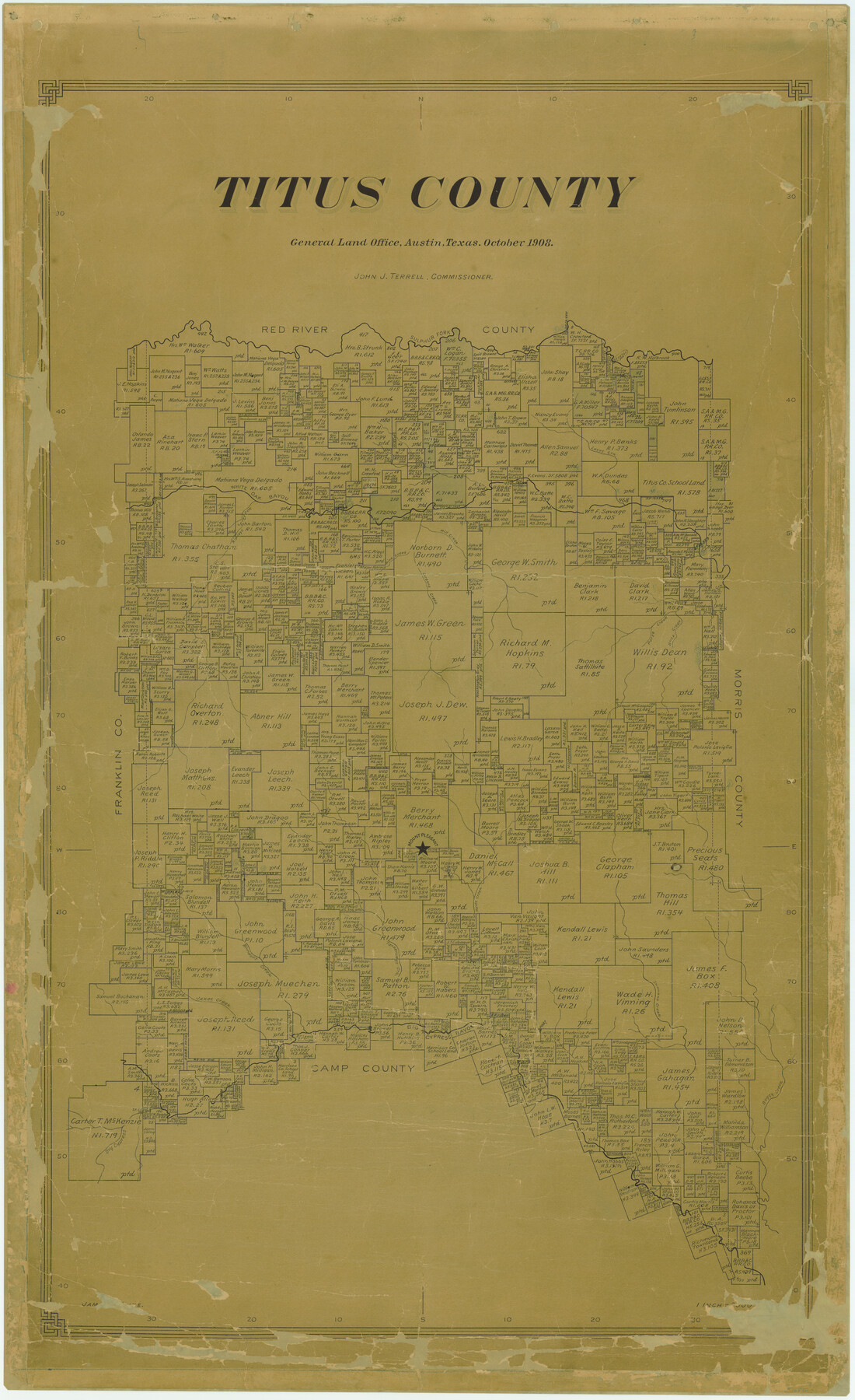
Titus County
-
Map/Doc
16896
-
Collection
General Map Collection
-
Object Dates
1908 (Creation Date)
-
People and Organizations
Texas General Land Office (Publisher)
James K. Duke (Draftsman)
John J. Terrell (GLO Commissioner)
James K. Duke (Compiler)
-
Counties
Titus
-
Subjects
County
-
Height x Width
42.5 x 26.0 inches
108.0 x 66.0 cm
-
Comments
List of School Files and Scrap Files on reverse side of map, see counter number 81969.
Conservation funded in 2004 with donation from Pilgrim Bank. -
Features
Buck Creek
Dry Cypress Creek
Boggy Creek
Jakes Creek
Big Cypress Bayou
Swanano Creek
Tankersleys Creek
Blundells Creek
Harts Creek
Mount Pleasant
Sulphur Fork [of Red River]
Greens Creek
Horse Creek
Snake Creek
Mill Creek
Pine Creek
Ripleys Creek
White Oak Bayou
Lacys Creek
Part of: General Map Collection
San Jacinto County Working Sketch 19

Print $20.00
- Digital $50.00
San Jacinto County Working Sketch 19
1939
Size 25.4 x 25.2 inches
Map/Doc 63732
Flight Mission No. DAG-21K, Frame 117, Matagorda County

Print $20.00
- Digital $50.00
Flight Mission No. DAG-21K, Frame 117, Matagorda County
1952
Size 18.5 x 22.4 inches
Map/Doc 86440
Calhoun County Rolled Sketch 28A

Print $20.00
- Digital $50.00
Calhoun County Rolled Sketch 28A
1834
Size 23.1 x 33.1 inches
Map/Doc 5375
Rio Grande Rectification Project, El Paso and Juarez Valley

Print $20.00
- Digital $50.00
Rio Grande Rectification Project, El Paso and Juarez Valley
1935
Size 11.0 x 29.7 inches
Map/Doc 60864
Montgomery County Working Sketch 35

Print $20.00
- Digital $50.00
Montgomery County Working Sketch 35
1953
Size 26.6 x 21.7 inches
Map/Doc 71142
Wilson County Working Sketch 8

Print $20.00
- Digital $50.00
Wilson County Working Sketch 8
1975
Size 36.5 x 31.9 inches
Map/Doc 72588
Glasscock County Working Sketch 8

Print $40.00
- Digital $50.00
Glasscock County Working Sketch 8
1955
Size 43.5 x 120.3 inches
Map/Doc 63181
Mitchell County Working Sketch 2

Print $20.00
- Digital $50.00
Mitchell County Working Sketch 2
1922
Size 14.8 x 18.1 inches
Map/Doc 71059
Hunt County Working Sketch 3

Print $20.00
- Digital $50.00
Hunt County Working Sketch 3
1923
Size 20.6 x 28.2 inches
Map/Doc 66350
Hall County Sketch File A

Print $6.00
- Digital $50.00
Hall County Sketch File A
Size 8.0 x 16.9 inches
Map/Doc 24778
Hudspeth County Rolled Sketch 66

Print $20.00
- Digital $50.00
Hudspeth County Rolled Sketch 66
1973
Size 12.1 x 19.9 inches
Map/Doc 6260
Coryell County Working Sketch 19

Print $20.00
- Digital $50.00
Coryell County Working Sketch 19
1970
Size 38.7 x 33.2 inches
Map/Doc 68226
You may also like
Terry County Sketch File 18

Print $36.00
- Digital $50.00
Terry County Sketch File 18
Size 8.9 x 11.4 inches
Map/Doc 38039
Dickens County Rolled Sketch 10

Print $20.00
- Digital $50.00
Dickens County Rolled Sketch 10
Size 43.0 x 31.9 inches
Map/Doc 8789
Liberty County Sketch File 44

Print $2.00
- Digital $50.00
Liberty County Sketch File 44
Size 6.0 x 10.3 inches
Map/Doc 30002
Shelby County Working Sketch 8

Print $20.00
- Digital $50.00
Shelby County Working Sketch 8
1942
Size 20.0 x 30.3 inches
Map/Doc 63861
Sterling County Working Sketch 10

Print $20.00
- Digital $50.00
Sterling County Working Sketch 10
1980
Size 39.6 x 26.3 inches
Map/Doc 63992
Hudspeth County Sketch File 39

Print $42.00
- Digital $50.00
Hudspeth County Sketch File 39
Size 8.8 x 11.5 inches
Map/Doc 27010
Harris County Historic Topographic 8

Print $20.00
- Digital $50.00
Harris County Historic Topographic 8
1916
Size 29.8 x 23.1 inches
Map/Doc 65818
Collingsworth County Working Sketch 5

Print $20.00
- Digital $50.00
Collingsworth County Working Sketch 5
1973
Size 22.5 x 38.2 inches
Map/Doc 68093
Ward County Working Sketch 46

Print $20.00
- Digital $50.00
Ward County Working Sketch 46
1974
Size 35.0 x 38.3 inches
Map/Doc 72352
Brewster County Rolled Sketch 136

Print $20.00
- Digital $50.00
Brewster County Rolled Sketch 136
Size 21.4 x 13.2 inches
Map/Doc 5304
Jefferson County Working Sketch 14

Print $20.00
- Digital $50.00
Jefferson County Working Sketch 14
1948
Size 30.3 x 25.8 inches
Map/Doc 66557
Flight Mission No. DAG-24K, Frame 47, Matagorda County

Print $20.00
- Digital $50.00
Flight Mission No. DAG-24K, Frame 47, Matagorda County
1953
Size 18.5 x 22.3 inches
Map/Doc 86534