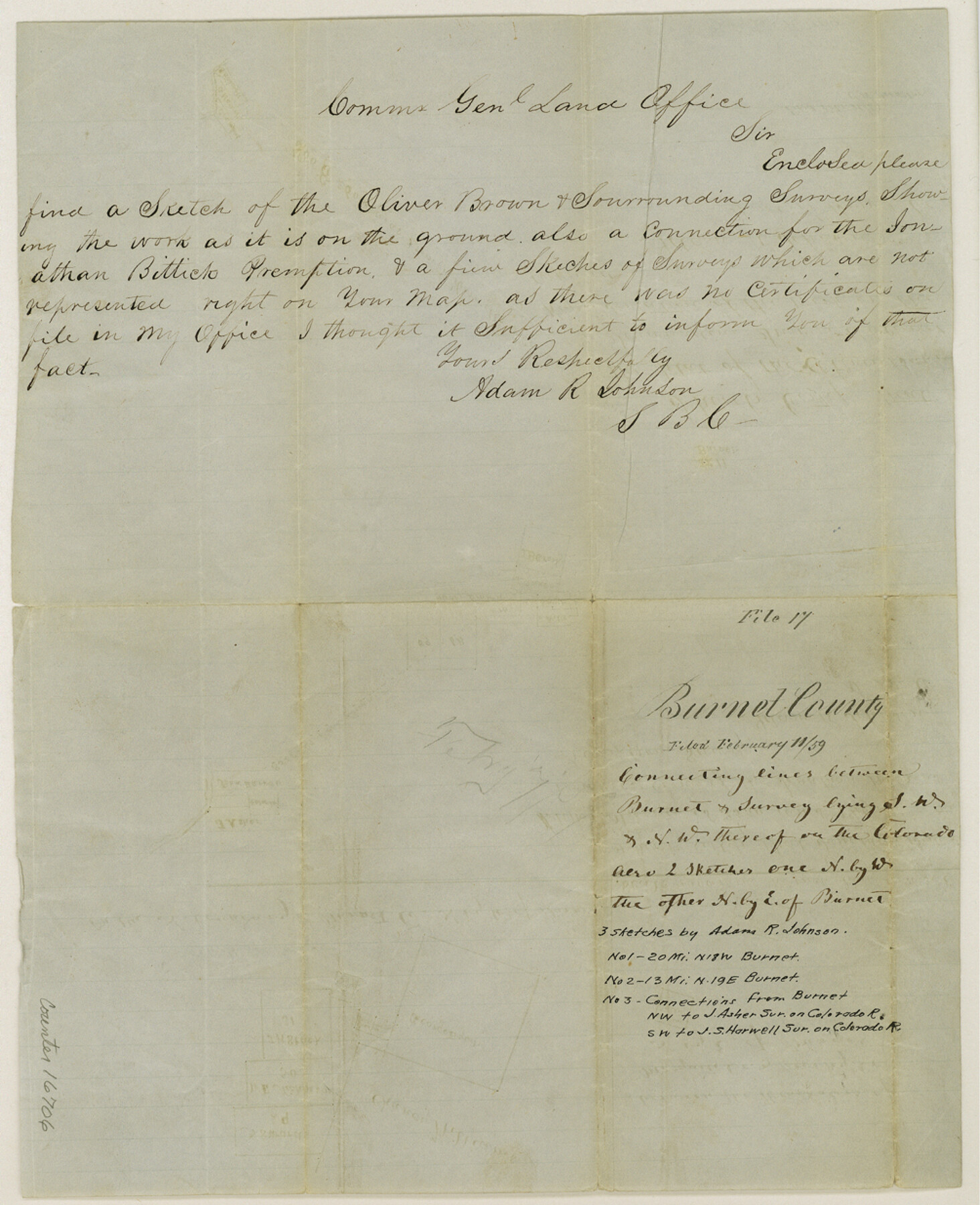
Burnet County Sketch File 17
[Connecting lines and sketches between Burnet and surveys lying SW and NW on the Colorado River]
-
Map/Doc
16706
-
Collection
General Map Collection
-
Object Dates
1859/2/11 (File Date)
-
People and Organizations
Adam R. Johnson (Surveyor/Engineer)
-
Counties
Burnet
-
Subjects
Surveying Sketch File
-
Height x Width
12.4 x 10.1 inches
31.5 x 25.7 cm
-
Medium
paper, manuscript
-
Features
[Colorado River]
Part of: General Map Collection
Robertson County Working Sketch 15

Print $20.00
- Digital $50.00
Robertson County Working Sketch 15
1984
Size 28.7 x 25.2 inches
Map/Doc 63588
Parker County Sketch File 20

Print $4.00
- Digital $50.00
Parker County Sketch File 20
Size 5.2 x 6.5 inches
Map/Doc 33558
Amistad International Reservoir on Rio Grande 61

Print $20.00
- Digital $50.00
Amistad International Reservoir on Rio Grande 61
1949
Size 28.4 x 39.4 inches
Map/Doc 73346
Val Verde County Working Sketch 117

Print $20.00
- Digital $50.00
Val Verde County Working Sketch 117
1993
Size 17.5 x 24.4 inches
Map/Doc 82848
Archer County Rolled Sketch 10

Print $20.00
- Digital $50.00
Archer County Rolled Sketch 10
2012
Size 19.2 x 24.6 inches
Map/Doc 93326
San Patricio County Rolled Sketch 30A

Print $20.00
- Digital $50.00
San Patricio County Rolled Sketch 30A
1941
Size 23.3 x 30.4 inches
Map/Doc 9897
Bexar County Boundary File 3

Print $6.00
- Digital $50.00
Bexar County Boundary File 3
Size 8.2 x 3.6 inches
Map/Doc 50536
Houston including Bellaire, Bunker Hill, Galena Park, Hedwig, Hilshire, Hunters Creek, Jacinto City, Jersey Village, Missouri City, Pasadena, Piney Point, South Houston, Spring Valley, West University Place and adjoining communities [Verso]
![94180, Houston including Bellaire, Bunker Hill, Galena Park, Hedwig, Hilshire, Hunters Creek, Jacinto City, Jersey Village, Missouri City, Pasadena, Piney Point, South Houston, Spring Valley, West University Place and adjoining communities [Verso], General Map Collection](https://historictexasmaps.com/wmedia_w700/maps/94180.tif.jpg)
Houston including Bellaire, Bunker Hill, Galena Park, Hedwig, Hilshire, Hunters Creek, Jacinto City, Jersey Village, Missouri City, Pasadena, Piney Point, South Houston, Spring Valley, West University Place and adjoining communities [Verso]
Size 27.1 x 42.4 inches
Map/Doc 94180
Flight Mission No. CLL-1N, Frame 185, Willacy County

Print $20.00
- Digital $50.00
Flight Mission No. CLL-1N, Frame 185, Willacy County
1954
Size 18.4 x 22.1 inches
Map/Doc 87055
McMullen County Sketch File 20

Print $4.00
- Digital $50.00
McMullen County Sketch File 20
Size 8.1 x 10.0 inches
Map/Doc 31373
Brewster County Working Sketch 38

Print $20.00
- Digital $50.00
Brewster County Working Sketch 38
1944
Size 36.3 x 28.4 inches
Map/Doc 67572
Henderson County Rolled Sketch 11

Print $20.00
- Digital $50.00
Henderson County Rolled Sketch 11
1915
Size 29.3 x 42.6 inches
Map/Doc 75953
You may also like
[Mrs. May Vinson Survey]
![91959, [Mrs. May Vinson Survey], Twichell Survey Records](https://historictexasmaps.com/wmedia_w700/maps/91959-1.tif.jpg)
Print $40.00
- Digital $50.00
[Mrs. May Vinson Survey]
Size 48.4 x 21.9 inches
Map/Doc 91959
Haskell County Working Sketch 6

Print $20.00
- Digital $50.00
Haskell County Working Sketch 6
1949
Size 18.9 x 16.4 inches
Map/Doc 66064
Map of Bexar County

Print $40.00
- Digital $50.00
Map of Bexar County
1845
Size 49.0 x 46.5 inches
Map/Doc 87236
Fort Bend County State Real Property Sketch 17

Print $20.00
- Digital $50.00
Fort Bend County State Real Property Sketch 17
1985
Size 17.8 x 22.8 inches
Map/Doc 61665
Flight Mission No. DQN-1K, Frame 27, Calhoun County

Print $20.00
- Digital $50.00
Flight Mission No. DQN-1K, Frame 27, Calhoun County
1953
Size 18.5 x 22.1 inches
Map/Doc 84132
Brooks County Sketch File 1

Print $12.00
- Digital $50.00
Brooks County Sketch File 1
1923
Size 14.3 x 8.9 inches
Map/Doc 16537
Louisiana and Texas Intracoastal Waterway Proposed Extension to Rio Grande Valley

Print $20.00
- Digital $50.00
Louisiana and Texas Intracoastal Waterway Proposed Extension to Rio Grande Valley
1941
Size 28.1 x 41.1 inches
Map/Doc 61891
General Highway Map. Detail of Cities and Towns in Travis County, Texas. City Map, Austin and vicinity, Travis County, Texas

Print $20.00
General Highway Map. Detail of Cities and Towns in Travis County, Texas. City Map, Austin and vicinity, Travis County, Texas
1961
Size 24.8 x 18.1 inches
Map/Doc 79686
Harbor Pass and Bar at Brazos Santiago, Texas

Print $20.00
- Digital $50.00
Harbor Pass and Bar at Brazos Santiago, Texas
1871
Size 26.8 x 18.3 inches
Map/Doc 72984
Outer Continental Shelf Leasing Maps (Louisiana Offshore Operations)

Print $20.00
- Digital $50.00
Outer Continental Shelf Leasing Maps (Louisiana Offshore Operations)
1954
Size 15.8 x 10.0 inches
Map/Doc 76109
Terrell County Sketch File 25

Print $4.00
- Digital $50.00
Terrell County Sketch File 25
1935
Size 13.5 x 8.1 inches
Map/Doc 37959
Flight Mission No. DQO-2K, Frame 88, Galveston County

Print $20.00
- Digital $50.00
Flight Mission No. DQO-2K, Frame 88, Galveston County
1952
Size 18.8 x 22.5 inches
Map/Doc 85015