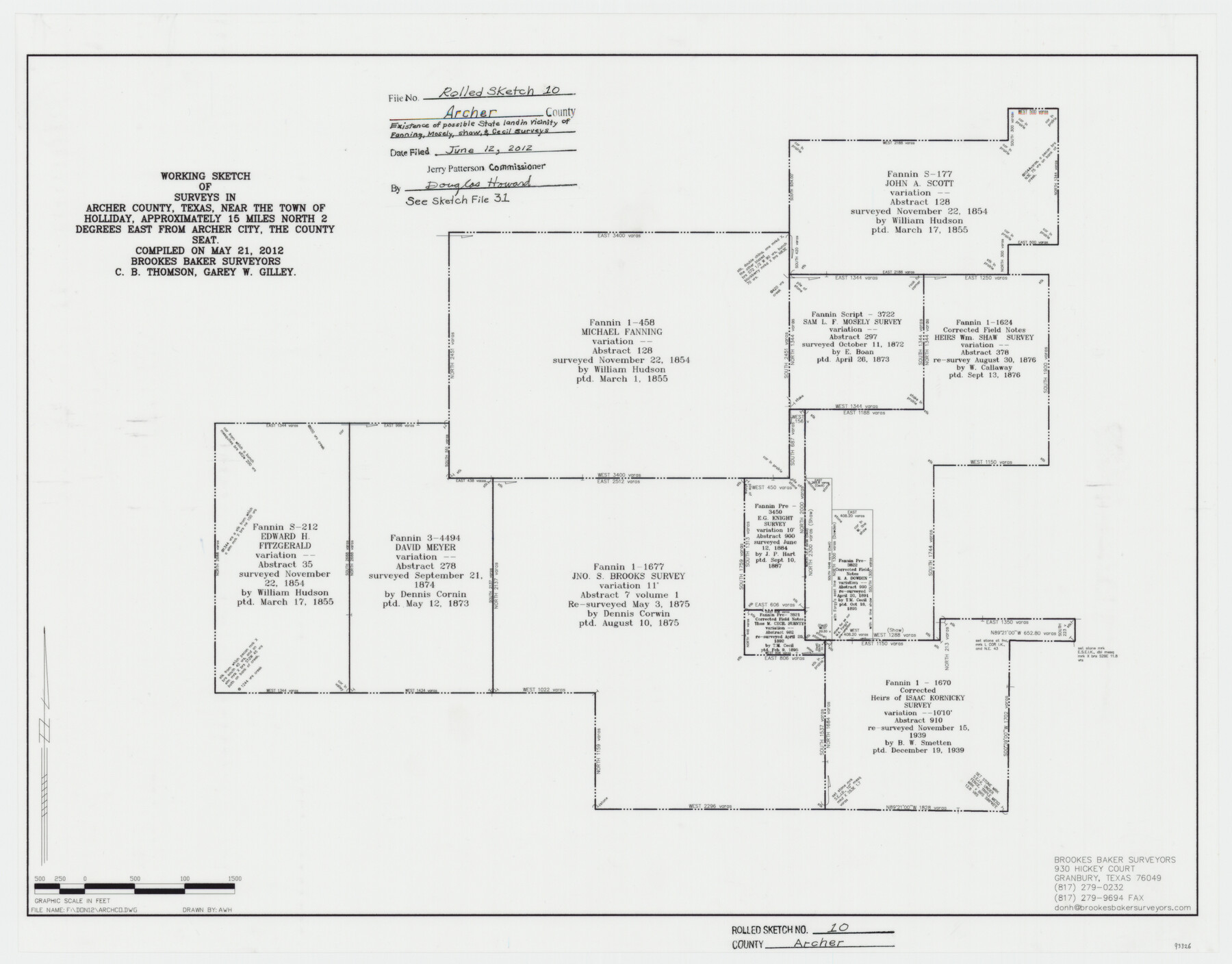
Archer County Rolled Sketch 10
Working sketch of surveys in Archer County, Texas, near the town of Holliday, approximately 15 Miles North 2 Degrees East from Archer City, the County Seat - existence of possible State land in vicinity of Fanning, Mosely, Shaw & Cecil surveys
- 
                          Map/Doc
93326
 - 
                            Collection
General Map Collection
 - 
                            Object Dates
2012/5/21 (Creation Date)
2012/6/12 (File Date)
 - 
                            People and Organizations
Garey W. Gilley (Surveyor/Engineer)
C.B. Thomson (Surveyor/Engineer)
 - 
                            Counties
Archer
 - 
                            Subjects
Surveying Rolled Sketch
 - 
                            Height x Width
19.2 x 24.6 inches
48.8 x 62.5 cm
 - 
                            Medium
mylar, print
 - 
                            Scale
1" = 500'
 - 
                            Comments
See Archer County Sketch File 31 (93322) for surveyor’s report.
 
Related maps
            Archer County Sketch File 31


                                            Print $8.00                    
                                             -                         Digital $50.00                                    
                Archer County Sketch File 31
2012
Size 11.0 x 8.5 inches
                                Map/Doc 93322
            Part of: General Map Collection
            Brazoria County Sketch File 26


                                            Print $40.00                    
                                             -                         Digital $50.00                                    
                Brazoria County Sketch File 26
Size 13.6 x 13.6 inches
                                Map/Doc 15028
            
            Pecos County Working Sketch 106


                                            Print $40.00                    
                                             -                         Digital $50.00                                    
                Pecos County Working Sketch 106
1971
Size 64.9 x 38.1 inches
                                Map/Doc 71579
            
            Boundary Between the United States & Mexico Agreed upon by the Joint Commission under the Treaty of Guadalupe Hidalgo


                                            Print $20.00                    
                                             -                         Digital $50.00                                    
                Boundary Between the United States & Mexico Agreed upon by the Joint Commission under the Treaty of Guadalupe Hidalgo
1853
Size 18.2 x 26.4 inches
                                Map/Doc 72883
            
            Chambers County Sketch File 32


                                            Print $8.00                    
                                             -                         Digital $50.00                                    
                Chambers County Sketch File 32
1900
Size 7.1 x 10.6 inches
                                Map/Doc 17616
            
            La Salle County Sketch File 33


                                            Print $2.00                    
                                             -                         Digital $50.00                                    
                La Salle County Sketch File 33
1875
Size 13.4 x 8.0 inches
                                Map/Doc 29584
            
            Edwards County Working Sketch 20


                                            Print $20.00                    
                                             -                         Digital $50.00                                    
                Edwards County Working Sketch 20
1935
Size 43.2 x 42.6 inches
                                Map/Doc 68896
            
            Comanche County


                                            Print $20.00                    
                                             -                         Digital $50.00                                    
                Comanche County
1896
Size 39.4 x 44.2 inches
                                Map/Doc 4734
            
            Hudspeth County Rolled Sketch 39


                                            Print $40.00                    
                                             -                         Digital $50.00                                    
                Hudspeth County Rolled Sketch 39
1935
Size 21.7 x 88.2 inches
                                Map/Doc 9212
            
            Atascosa County Sketch File 8


                                            Print $6.00                    
                                             -                         Digital $50.00                                    
                Atascosa County Sketch File 8
1857
Size 8.7 x 7.7 inches
                                Map/Doc 13758
            
            Jack County Boundary File 3


                                            Print $10.00                    
                                             -                         Digital $50.00                                    
                Jack County Boundary File 3
Size 9.2 x 4.0 inches
                                Map/Doc 55408
            
            Map of Panola County


                                            Print $20.00                    
                                             -                         Digital $50.00                                    
                Map of Panola County
1882
Size 20.9 x 22.0 inches
                                Map/Doc 4504
            
            Henderson County Working Sketch 31


                                            Print $20.00                    
                                             -                         Digital $50.00                                    
                Henderson County Working Sketch 31
1962
Size 38.7 x 39.6 inches
                                Map/Doc 66164
            You may also like
            [Cherokee Reserve, West Boundary Line, plat and field notes]


                                            Print $54.00                    
                                    
                [Cherokee Reserve, West Boundary Line, plat and field notes]
1841
Size 9.4 x 14.7 inches
                                Map/Doc 2000
            
            Taylor County Sketch File A1


                                            Print $40.00                    
                                             -                         Digital $50.00                                    
                Taylor County Sketch File A1
Size 12.8 x 14.3 inches
                                Map/Doc 37774
            
            Flight Mission No. CGI-3N, Frame 109, Cameron County


                                            Print $20.00                    
                                             -                         Digital $50.00                                    
                Flight Mission No. CGI-3N, Frame 109, Cameron County
1954
Size 18.5 x 22.1 inches
                                Map/Doc 84589
            
            Wichita County Sketch File 19


                                            Print $20.00                    
                                             -                         Digital $50.00                                    
                Wichita County Sketch File 19
Size 21.9 x 22.5 inches
                                Map/Doc 12681
            
            Nueces County Sketch File 29


                                            Print $40.00                    
                                             -                         Digital $50.00                                    
                Nueces County Sketch File 29
1907
Size 17.2 x 14.2 inches
                                Map/Doc 32598
            
            Gregg County Working Sketch Graphic Index


                                            Print $20.00                    
                                             -                         Digital $50.00                                    
                Gregg County Working Sketch Graphic Index
1933
Size 32.4 x 29.5 inches
                                Map/Doc 76559
            
            Flight Mission No. CRC-1R, Frame 34, Chambers County


                                            Print $20.00                    
                                             -                         Digital $50.00                                    
                Flight Mission No. CRC-1R, Frame 34, Chambers County
1956
Size 18.8 x 22.4 inches
                                Map/Doc 84702
            
            General Highway Map, Edwards County, Real County, Texas


                                            Print $20.00                    
                                    
                General Highway Map, Edwards County, Real County, Texas
1940
Size 18.3 x 24.8 inches
                                Map/Doc 79082
            
            Castro County Sketch File 2


                                            Print $20.00                    
                                             -                         Digital $50.00                                    
                Castro County Sketch File 2
Size 24.7 x 17.7 inches
                                Map/Doc 11057
            
            [Sketch for Mineral Application 33721 - 33725  Incl. - Padre and Mustang Island]


                                            Print $20.00                    
                                             -                         Digital $50.00                                    
                [Sketch for Mineral Application 33721 - 33725 Incl. - Padre and Mustang Island]
1942
Size 29.8 x 22.6 inches
                                Map/Doc 2877
            
            Flight Mission No. CUG-2P, Frame 12, Kleberg County


                                            Print $20.00                    
                                             -                         Digital $50.00                                    
                Flight Mission No. CUG-2P, Frame 12, Kleberg County
1956
Size 18.6 x 22.1 inches
                                Map/Doc 86184
            
            Dickens County Working Sketch 14


                                            Print $20.00                    
                                             -                         Digital $50.00                                    
                Dickens County Working Sketch 14
1986
Size 25.5 x 30.7 inches
                                Map/Doc 62180