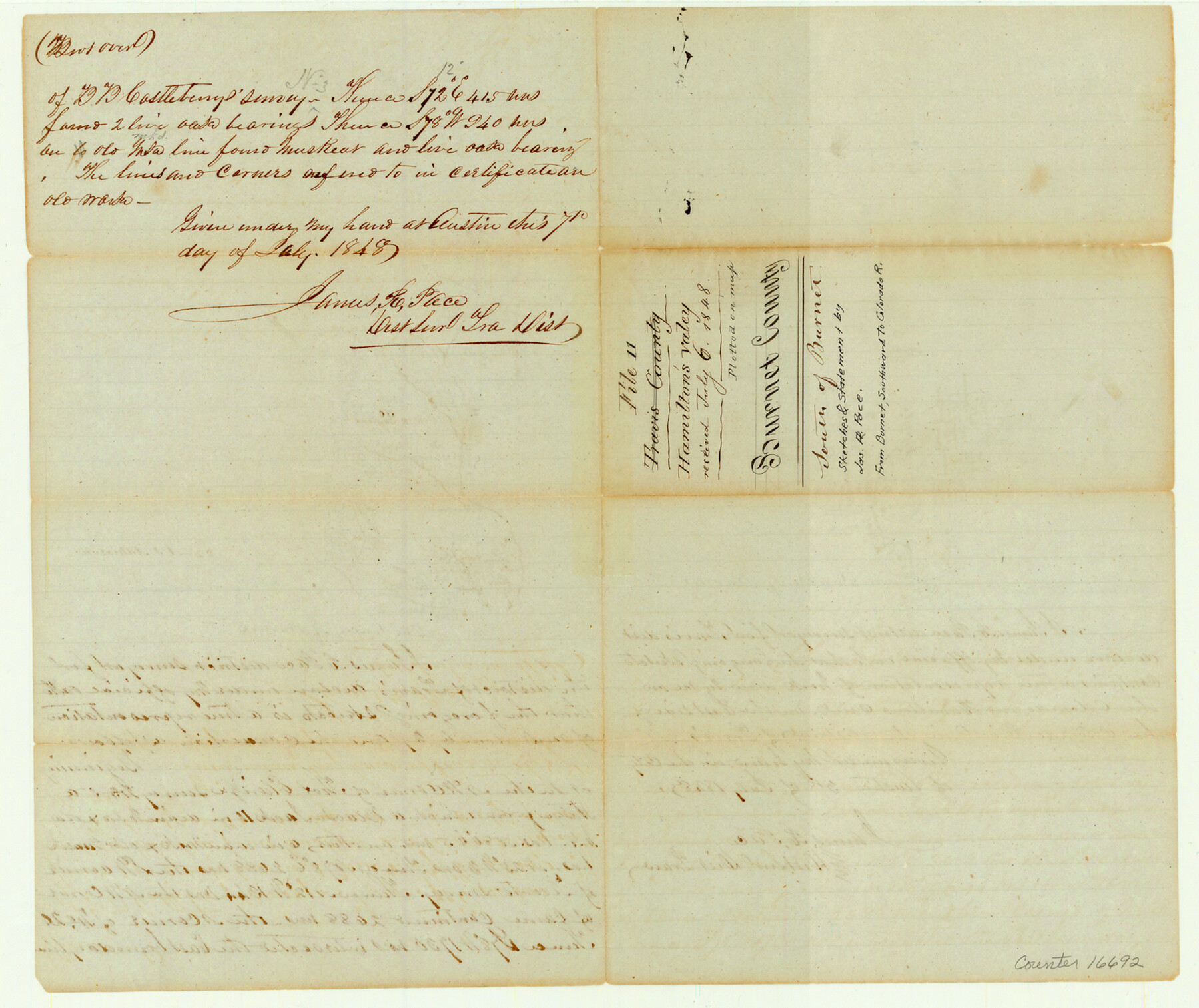
Burnet County Sketch File 11
[Sketches and statement of two separate areas both due south of Burnet]
-
Map/Doc
16692
-
Collection
General Map Collection
-
Object Dates
1848/7/6 (File Date)
1848/7/3 (Creation Date)
-
People and Organizations
James R. Pace (Surveyor/Engineer)
-
Counties
Burnet
-
Subjects
Surveying Sketch File
-
Height x Width
12.8 x 15.2 inches
32.5 x 38.6 cm
-
Medium
paper, manuscript
-
Features
Hamilton Creek
Colorado River
Part of: General Map Collection
Haskell County Sketch File 9

Print $30.00
- Digital $50.00
Haskell County Sketch File 9
Size 23.2 x 14.9 inches
Map/Doc 26130
Atascosa County Sketch File 42

Print $12.00
- Digital $50.00
Atascosa County Sketch File 42
1916
Size 11.2 x 8.8 inches
Map/Doc 13847
Surveys in Austin's Colony along the Colorado River below the San Antonio Road

Print $20.00
- Digital $50.00
Surveys in Austin's Colony along the Colorado River below the San Antonio Road
1830
Size 38.2 x 13.5 inches
Map/Doc 193
Bandera County Working Sketch 20

Print $20.00
- Digital $50.00
Bandera County Working Sketch 20
1947
Size 25.4 x 19.8 inches
Map/Doc 67616
Hood County Working Sketch 25

Print $20.00
- Digital $50.00
Hood County Working Sketch 25
1995
Size 25.8 x 37.7 inches
Map/Doc 66219
Galveston County Rolled Sketch 32

Print $20.00
- Digital $50.00
Galveston County Rolled Sketch 32
1979
Size 44.3 x 31.0 inches
Map/Doc 9015
Map of Yoakum County

Print $20.00
- Digital $50.00
Map of Yoakum County
1902
Size 47.2 x 35.3 inches
Map/Doc 16934
Val Verde County Sketch File 44

Print $22.00
- Digital $50.00
Val Verde County Sketch File 44
1940
Size 9.0 x 14.2 inches
Map/Doc 39309
Starr County Sketch File 19

Print $20.00
- Digital $50.00
Starr County Sketch File 19
1887
Size 22.6 x 22.0 inches
Map/Doc 12330
[Corpus Christi Bay, Padre Island, Mustang Island, Laguna de la Madre, King and Kenedy's Pasture]
![73042, [Corpus Christi Bay, Padre Island, Mustang Island, Laguna de la Madre, King and Kenedy's Pasture], General Map Collection](https://historictexasmaps.com/wmedia_w700/maps/73042.tif.jpg)
Print $20.00
- Digital $50.00
[Corpus Christi Bay, Padre Island, Mustang Island, Laguna de la Madre, King and Kenedy's Pasture]
Size 26.2 x 18.2 inches
Map/Doc 73042
Roberts County

Print $20.00
- Digital $50.00
Roberts County
1878
Size 20.1 x 18.0 inches
Map/Doc 3991
Terrell County Working Sketch 63

Print $20.00
- Digital $50.00
Terrell County Working Sketch 63
1970
Size 37.8 x 35.9 inches
Map/Doc 69584
You may also like
Zapata County Rolled Sketch 20

Print $40.00
- Digital $50.00
Zapata County Rolled Sketch 20
1956
Size 21.2 x 49.1 inches
Map/Doc 10171
Karnes County Working Sketch 9

Print $20.00
- Digital $50.00
Karnes County Working Sketch 9
1962
Size 37.1 x 28.9 inches
Map/Doc 66657
Harris County Working Sketch 22

Print $20.00
- Digital $50.00
Harris County Working Sketch 22
Size 17.5 x 22.0 inches
Map/Doc 65914
Mills County Boundary File 1a

Print $60.00
- Digital $50.00
Mills County Boundary File 1a
Size 9.7 x 31.6 inches
Map/Doc 57273
Childress County

Print $20.00
- Digital $50.00
Childress County
1884
Size 20.6 x 17.4 inches
Map/Doc 3395
Flight Mission No. DAH-9M, Frame 161, Orange County

Print $20.00
- Digital $50.00
Flight Mission No. DAH-9M, Frame 161, Orange County
1953
Size 18.6 x 22.4 inches
Map/Doc 86860
Sutton County Working Sketch 8

Print $20.00
- Digital $50.00
Sutton County Working Sketch 8
Size 14.2 x 21.6 inches
Map/Doc 62351
Flight Mission No. CRE-1R, Frame 196, Jackson County

Print $20.00
- Digital $50.00
Flight Mission No. CRE-1R, Frame 196, Jackson County
1956
Size 18.6 x 22.4 inches
Map/Doc 85350
Sherman County Rolled Sketch 12

Print $40.00
- Digital $50.00
Sherman County Rolled Sketch 12
1951
Size 11.5 x 64.0 inches
Map/Doc 9931
[Sketch Showing Surveys north of South Canadian River, Hemphill County, Texas]
![10759, [Sketch Showing Surveys north of South Canadian River, Hemphill County, Texas], Maddox Collection](https://historictexasmaps.com/wmedia_w700/maps/10759-GC.tif.jpg)
Print $3.00
- Digital $50.00
[Sketch Showing Surveys north of South Canadian River, Hemphill County, Texas]
Size 9.8 x 14.9 inches
Map/Doc 10759
Flight Mission No. DCL-6C, Frame 8, Kenedy County

Print $20.00
- Digital $50.00
Flight Mission No. DCL-6C, Frame 8, Kenedy County
1943
Size 18.5 x 22.5 inches
Map/Doc 85868
Crane County Rolled Sketch 24

Print $40.00
- Digital $50.00
Crane County Rolled Sketch 24
2002
Size 33.5 x 62.0 inches
Map/Doc 76427