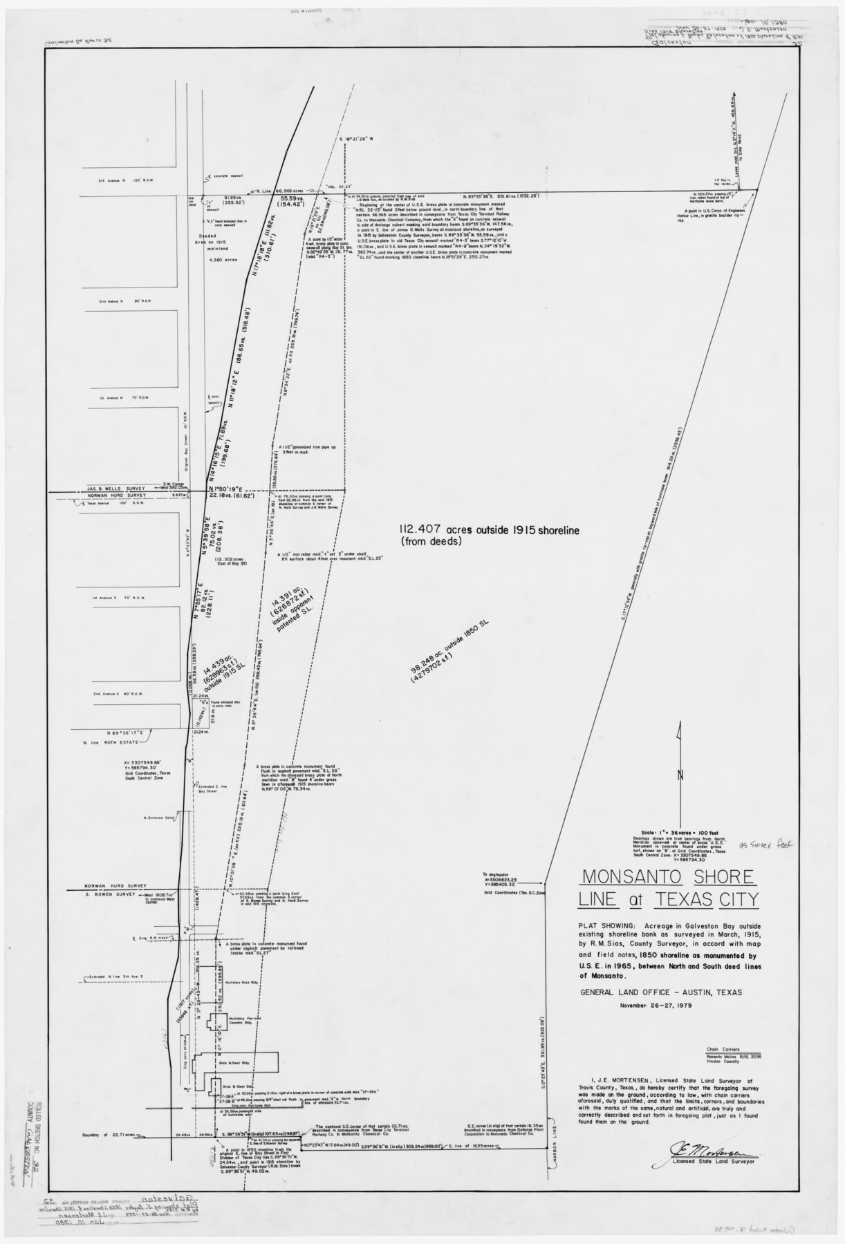
Galveston County Rolled Sketch 32
Monsanto Shoreline at Texas City
-
Map/Doc
9015
-
Collection
General Map Collection
-
Object Dates
11/27/1979 (Creation Date)
1/10/1980 (File Date)
-
People and Organizations
James E. Mortensen (Surveyor/Engineer)
Rosendo V. Molina (Chainman/Field Personnel)
Preston R. Connally (Chainman/Field Personnel)
-
Counties
Galveston
-
Subjects
Surveying Rolled Sketch
-
Height x Width
44.3 x 31.0 inches
112.5 x 78.7 cm
-
Medium
mylar, print
-
Scale
1" = 36 varas
Part of: General Map Collection
Hall County Boundary File 1

Print $26.00
- Digital $50.00
Hall County Boundary File 1
Size 8.8 x 4.0 inches
Map/Doc 54158
Edwards County Working Sketch 97

Print $20.00
- Digital $50.00
Edwards County Working Sketch 97
1969
Size 25.5 x 27.6 inches
Map/Doc 68973
Presidio County Sketch File 6

Print $20.00
- Digital $50.00
Presidio County Sketch File 6
Size 21.3 x 17.8 inches
Map/Doc 11705
Zavala County Sketch File 18

Print $16.00
- Digital $50.00
Zavala County Sketch File 18
1897
Size 14.0 x 9.1 inches
Map/Doc 41356
[Town lots on Galveston Island]
![11, [Town lots on Galveston Island], General Map Collection](https://historictexasmaps.com/wmedia_w700/maps/11.tif.jpg)
Print $20.00
- Digital $50.00
[Town lots on Galveston Island]
1839
Size 18.8 x 23.0 inches
Map/Doc 11
Swisher County Sketch File 7

Print $32.00
- Digital $50.00
Swisher County Sketch File 7
1904
Size 9.0 x 8.4 inches
Map/Doc 37622
San Jacinto River, Proposed Dam Site/Huntsville State Park

Print $6.00
- Digital $50.00
San Jacinto River, Proposed Dam Site/Huntsville State Park
1937
Size 30.2 x 26.6 inches
Map/Doc 65151
Childress County Sketch File 2a

Print $20.00
- Digital $50.00
Childress County Sketch File 2a
Size 18.3 x 34.8 inches
Map/Doc 11077
Hutchinson County Sketch File 26

Print $20.00
- Digital $50.00
Hutchinson County Sketch File 26
1920
Size 18.6 x 17.4 inches
Map/Doc 11816
Fisher County Sketch File 19

Print $20.00
- Digital $50.00
Fisher County Sketch File 19
Size 18.8 x 15.7 inches
Map/Doc 11481
Amistad International Reservoir on Rio Grande 62

Print $20.00
- Digital $50.00
Amistad International Reservoir on Rio Grande 62
1949
Size 28.2 x 39.6 inches
Map/Doc 73347
Flight Mission No. BQR-14K, Frame 36, Brazoria County

Print $20.00
- Digital $50.00
Flight Mission No. BQR-14K, Frame 36, Brazoria County
1952
Size 18.6 x 22.3 inches
Map/Doc 84093
You may also like
[Block 1 and surrounding blocks]
![90755, [Block 1 and surrounding blocks], Twichell Survey Records](https://historictexasmaps.com/wmedia_w700/maps/90755-1.tif.jpg)
Print $20.00
- Digital $50.00
[Block 1 and surrounding blocks]
1903
Size 18.8 x 19.8 inches
Map/Doc 90755
Harlem State Farm, East Tract

Print $3.00
- Digital $50.00
Harlem State Farm, East Tract
Size 15.6 x 11.9 inches
Map/Doc 62983
Flight Mission No. DAG-21K, Frame 133, Matagorda County

Print $20.00
- Digital $50.00
Flight Mission No. DAG-21K, Frame 133, Matagorda County
1952
Size 18.6 x 22.4 inches
Map/Doc 86459
Crockett County Sketch File 39

Print $20.00
- Digital $50.00
Crockett County Sketch File 39
1889
Size 19.7 x 32.6 inches
Map/Doc 11221
Presidio County Sketch File 37A

Print $18.00
- Digital $50.00
Presidio County Sketch File 37A
Size 11.4 x 8.8 inches
Map/Doc 34499
Gomez Section 1, Block D-12

Print $20.00
- Digital $50.00
Gomez Section 1, Block D-12
1955
Size 15.8 x 16.8 inches
Map/Doc 92321
[Sketch for Mineral Application 24072, San Jacinto River]
![65601, [Sketch for Mineral Application 24072, San Jacinto River], General Map Collection](https://historictexasmaps.com/wmedia_w700/maps/65601.tif.jpg)
Print $20.00
- Digital $50.00
[Sketch for Mineral Application 24072, San Jacinto River]
1929
Size 25.1 x 18.4 inches
Map/Doc 65601
San Patricio County Rolled Sketch 29C

Print $40.00
- Digital $50.00
San Patricio County Rolled Sketch 29C
Size 49.5 x 61.0 inches
Map/Doc 48872
Van Zandt County Sketch File 24

Print $4.00
- Digital $50.00
Van Zandt County Sketch File 24
1858
Size 6.7 x 7.9 inches
Map/Doc 39439
Map of Survey of that portion of Fort Crockett, County of Galveston, Texas, lying east of 53rd Street & West of 39th Street, City of Galveston

Print $40.00
- Digital $50.00
Map of Survey of that portion of Fort Crockett, County of Galveston, Texas, lying east of 53rd Street & West of 39th Street, City of Galveston
1957
Size 23.0 x 59.8 inches
Map/Doc 73618
[Sketch showing Block AX, North part of Block G, Block S and part of Block D]
![92018, [Sketch showing Block AX, North part of Block G, Block S and part of Block D], Twichell Survey Records](https://historictexasmaps.com/wmedia_w700/maps/92018-1.tif.jpg)
Print $20.00
- Digital $50.00
[Sketch showing Block AX, North part of Block G, Block S and part of Block D]
Size 33.2 x 44.1 inches
Map/Doc 92018
![91463, [Block B7], Twichell Survey Records](https://historictexasmaps.com/wmedia_w700/maps/91463-1.tif.jpg)