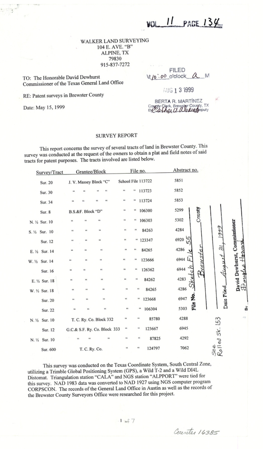
Brewster County Sketch File 55
[Report of survey made in J.V. Massey Block C, B. S. & F. Block D, T. C. Ry. Co., Block 332 and G. C. & S. F. Ry. Co. Block 333]
-
Map/Doc
16385
-
Collection
General Map Collection
-
Object Dates
1999/5/15 (Creation Date)
1999/8/31 (File Date)
-
People and Organizations
Steven F. Walker (Surveyor/Engineer)
-
Counties
Brewster
-
Subjects
Surveying Sketch File
-
Height x Width
10.9 x 6.4 inches
27.7 x 16.3 cm
-
Medium
paper, print
-
Comments
See Brewster County Rolled Sketch 153 (5320) for sketch.
-
Features
Elephant Mountain
Santiago Peak
Santiago Spring
Related maps
Brewster County Rolled Sketch 153

Print $20.00
- Digital $50.00
Brewster County Rolled Sketch 153
Size 32.4 x 19.2 inches
Map/Doc 5320
Part of: General Map Collection
Hardin County Sketch File 32

Print $8.00
- Digital $50.00
Hardin County Sketch File 32
Size 12.9 x 8.3 inches
Map/Doc 25163
Wichita County Working Sketch 2

Print $20.00
- Digital $50.00
Wichita County Working Sketch 2
1913
Size 20.0 x 18.7 inches
Map/Doc 72511
Hunt County Boundary File 2

Print $6.00
- Digital $50.00
Hunt County Boundary File 2
Size 13.0 x 8.1 inches
Map/Doc 55189
La Salle County Rolled Sketch 23A

Print $225.00
- Digital $50.00
La Salle County Rolled Sketch 23A
1956
Size 10.0 x 15.6 inches
Map/Doc 46481
Schleicher County Sketch File 44

Print $4.00
- Digital $50.00
Schleicher County Sketch File 44
1950
Size 8.9 x 14.4 inches
Map/Doc 36550
Atascosa County Boundary File 3

Print $18.00
- Digital $50.00
Atascosa County Boundary File 3
Size 8.7 x 8.5 inches
Map/Doc 50168
Reagan County Rolled Sketch 27

Print $40.00
- Digital $50.00
Reagan County Rolled Sketch 27
Size 66.0 x 47.2 inches
Map/Doc 9821
[Sketch for Mineral Application 11108 - Greens Bayou]
![2786, [Sketch for Mineral Application 11108 - Greens Bayou], General Map Collection](https://historictexasmaps.com/wmedia_w700/maps/2786-1.tif.jpg)
Print $20.00
- Digital $50.00
[Sketch for Mineral Application 11108 - Greens Bayou]
1922
Size 46.0 x 21.0 inches
Map/Doc 2786
Live Oak County Working Sketch 12

Print $20.00
- Digital $50.00
Live Oak County Working Sketch 12
1949
Size 23.1 x 19.7 inches
Map/Doc 70597
Gonzales County

Print $20.00
- Digital $50.00
Gonzales County
1869
Size 22.2 x 22.1 inches
Map/Doc 3592
Galveston County NRC Article 33.136 Location Key Sheet

Print $20.00
- Digital $50.00
Galveston County NRC Article 33.136 Location Key Sheet
1994
Size 27.0 x 23.0 inches
Map/Doc 77018
Terrell County Working Sketch 34

Print $20.00
- Digital $50.00
Terrell County Working Sketch 34
1945
Size 26.3 x 37.7 inches
Map/Doc 62126
You may also like
Kerr County Rolled Sketch 27

Print $20.00
- Digital $50.00
Kerr County Rolled Sketch 27
1983
Size 33.1 x 33.5 inches
Map/Doc 6506
[Blocks 36, 37 Township 2 South]
![92320, [Blocks 36, 37 Township 2 South], Twichell Survey Records](https://historictexasmaps.com/wmedia_w700/maps/92320-1.tif.jpg)
Print $20.00
- Digital $50.00
[Blocks 36, 37 Township 2 South]
Size 24.6 x 18.9 inches
Map/Doc 92320
Maverick County Sketch File 3

Print $40.00
- Digital $50.00
Maverick County Sketch File 3
Size 18.3 x 11.6 inches
Map/Doc 31033
Dickens County Sketch File H1

Print $20.00
- Digital $50.00
Dickens County Sketch File H1
1902
Size 16.7 x 15.1 inches
Map/Doc 11336
Kerr County Working Sketch 32

Print $20.00
- Digital $50.00
Kerr County Working Sketch 32
1975
Size 33.8 x 25.3 inches
Map/Doc 70063
[Sketch showing Miguel Perez, Juan Jose Solis and Francisco Antonio Villareal surveys in Starr County]
![75549, [Sketch showing Miguel Perez, Juan Jose Solis and Francisco Antonio Villareal surveys in Starr County], Maddox Collection](https://historictexasmaps.com/wmedia_w700/maps/75549.tif.jpg)
Print $20.00
- Digital $50.00
[Sketch showing Miguel Perez, Juan Jose Solis and Francisco Antonio Villareal surveys in Starr County]
1914
Size 20.9 x 13.6 inches
Map/Doc 75549
Roberts County Working Sketch 37

Print $20.00
- Digital $50.00
Roberts County Working Sketch 37
1978
Size 26.6 x 22.5 inches
Map/Doc 63563
Red River County Working Sketch 59

Print $20.00
- Digital $50.00
Red River County Working Sketch 59
1972
Size 31.1 x 47.2 inches
Map/Doc 72042
[Surveys in Hopkins and Wood Counties]
![365, [Surveys in Hopkins and Wood Counties], General Map Collection](https://historictexasmaps.com/wmedia_w700/maps/365-1.tif.jpg)
Print $20.00
- Digital $50.00
[Surveys in Hopkins and Wood Counties]
1838
Size 24.7 x 31.7 inches
Map/Doc 365
Newton County Working Sketch 35

Print $20.00
- Digital $50.00
Newton County Working Sketch 35
1969
Size 37.4 x 32.3 inches
Map/Doc 71281
Brazos River, Clodine Sheet

Print $4.00
- Digital $50.00
Brazos River, Clodine Sheet
1930
Size 21.8 x 24.6 inches
Map/Doc 65287
Sketch in Lynn, Terry, Gaines & Dawson Counties, Texas

Print $40.00
- Digital $50.00
Sketch in Lynn, Terry, Gaines & Dawson Counties, Texas
1940
Size 52.5 x 32.6 inches
Map/Doc 89685