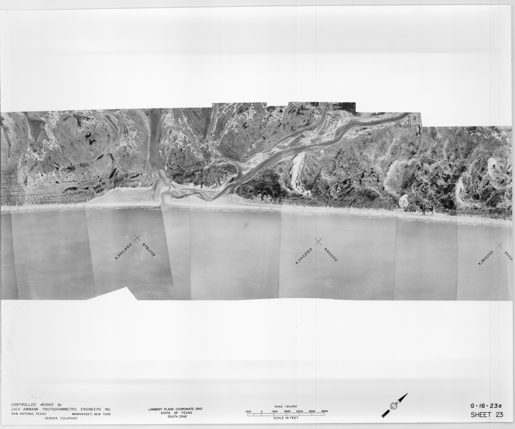
Controlled Mosaic by Jack Amman Photogrammetric Engineers, Inc - Sheet 23
[Coastal Aerial Photograph]
G-16-23a-b
- 
                          Map/Doc
83473
 - 
                            Collection
General Map Collection
 - 
                            Object Dates
1954 (Creation Date)
 - 
                            Subjects
Aerial Photograph
 - 
                            Height x Width
20.0 x 24.0 inches
50.8 x 61.0 cm
 - 
                            Comments
Statement on reverse side: "The reverse reflects the data shown thereon which was obtained by aerial survey made from December 31, 1953 to March 17, 1954 by Jack Ammann Photogrammetric Engineers, Inc."
 
Part of: General Map Collection
            Atascosa County Sketch File 21


                                            Print $40.00                    
                                             -                         Digital $50.00                                    
                Atascosa County Sketch File 21
Size 20.0 x 19.8 inches
                                Map/Doc 10859
            
            Outer Continental Shelf Leasing Maps (Louisiana Offshore Operations)


                                            Print $20.00                    
                                             -                         Digital $50.00                                    
                Outer Continental Shelf Leasing Maps (Louisiana Offshore Operations)
1954
Size 22.2 x 12.0 inches
                                Map/Doc 76096
            
            Culberson County Sketch File 42


                                            Print $14.00                    
                                             -                         Digital $50.00                                    
                Culberson County Sketch File 42
1966
Size 14.2 x 8.7 inches
                                Map/Doc 20322
            
            Map of Central Europe engraved to illustrate Mitchell's new intermediate geography


                                            Print $20.00                    
                                             -                         Digital $50.00                                    
                Map of Central Europe engraved to illustrate Mitchell's new intermediate geography
1885
Size 9.0 x 12.2 inches
                                Map/Doc 93528
            
            Real County Rolled Sketch 12


                                            Print $40.00                    
                                             -                         Digital $50.00                                    
                Real County Rolled Sketch 12
Size 42.7 x 54.6 inches
                                Map/Doc 9836
            
            Map of Bexar County


                                            Print $40.00                    
                                             -                         Digital $50.00                                    
                Map of Bexar County
1887
Size 46.1 x 48.6 inches
                                Map/Doc 16942
            
            [Surveys along the Nueces River in San Patricio County]


                                            Print $2.00                    
                                             -                         Digital $50.00                                    
                [Surveys along the Nueces River in San Patricio County]
1842
Size 8.8 x 9.9 inches
                                Map/Doc 69737
            
            Padre Island National Seashore


                                            Print $4.00                    
                                             -                         Digital $50.00                                    
                Padre Island National Seashore
Size 16.0 x 21.9 inches
                                Map/Doc 60526
            
            Brooks County Sketch File 3


                                            Print $40.00                    
                                             -                         Digital $50.00                                    
                Brooks County Sketch File 3
Size 21.5 x 19.0 inches
                                Map/Doc 11016
            
            Galveston County


                                            Print $40.00                    
                                             -                         Digital $50.00                                    
                Galveston County
1939
Size 45.0 x 57.6 inches
                                Map/Doc 1835
            
            Flight Mission No. CRE-1R, Frame 136, Jackson County


                                            Print $20.00                    
                                             -                         Digital $50.00                                    
                Flight Mission No. CRE-1R, Frame 136, Jackson County
1956
Size 16.0 x 15.9 inches
                                Map/Doc 85344
            
            Fayette County Sketch File 5


                                            Print $4.00                    
                                             -                         Digital $50.00                                    
                Fayette County Sketch File 5
Size 14.3 x 8.7 inches
                                Map/Doc 22506
            You may also like
            Hutchinson County


                                            Print $20.00                    
                                             -                         Digital $50.00                                    
                Hutchinson County
1922
Size 14.6 x 17.6 inches
                                Map/Doc 91183
            
            Brewster County Sketch File 14


                                            Print $26.00                    
                                             -                         Digital $50.00                                    
                Brewster County Sketch File 14
Size 11.2 x 8.8 inches
                                Map/Doc 15746
            
            Marion County Working Sketch 5


                                            Print $20.00                    
                                             -                         Digital $50.00                                    
                Marion County Working Sketch 5
1910
Size 24.5 x 15.2 inches
                                Map/Doc 70780
            
            Travis County Sketch File 8


                                            Print $4.00                    
                                             -                         Digital $50.00                                    
                Travis County Sketch File 8
Size 10.2 x 8.1 inches
                                Map/Doc 38288
            
            Nautical Chart 11332 - Intracoastal Waterway - Galveston Bay to Cedar Lakes


                                            Print $40.00                    
                                             -                         Digital $50.00                                    
                Nautical Chart 11332 - Intracoastal Waterway - Galveston Bay to Cedar Lakes
1984
Size 22.3 x 60.3 inches
                                Map/Doc 69940
            
            Brazos River, Brazos River Sheet 3


                                            Print $6.00                    
                                             -                         Digital $50.00                                    
                Brazos River, Brazos River Sheet 3
1926
Size 23.6 x 35.2 inches
                                Map/Doc 65295
            
            A Map of the British Empire in North America


                                            Print $20.00                    
                                             -                         Digital $50.00                                    
                A Map of the British Empire in North America
1774
Size 22.1 x 15.1 inches
                                Map/Doc 93733
            
            Marion County Working Sketch 41


                                            Print $40.00                    
                                             -                         Digital $50.00                                    
                Marion County Working Sketch 41
1996
Size 34.0 x 48.5 inches
                                Map/Doc 70817
            
            Presidio County Working Sketch Graphic Index, South Part, Sheet 1 (Sketches 1 to 44)


                                            Print $20.00                    
                                             -                         Digital $50.00                                    
                Presidio County Working Sketch Graphic Index, South Part, Sheet 1 (Sketches 1 to 44)
1975
Size 32.3 x 38.0 inches
                                Map/Doc 76670
            
            Tarrant County State Real Property Sketch 3


                                            Print $20.00                    
                                             -                         Digital $50.00                                    
                Tarrant County State Real Property Sketch 3
2018
Size 35.1 x 23.8 inches
                                Map/Doc 95402
            
            Brazos River, Harlem-Imperial Farms Project


                                            Print $20.00                    
                                             -                         Digital $50.00                                    
                Brazos River, Harlem-Imperial Farms Project
1930
Size 28.3 x 25.5 inches
                                Map/Doc 69678
            
            Bowie County Working Sketch 16


                                            Print $20.00                    
                                             -                         Digital $50.00                                    
                Bowie County Working Sketch 16
1961
Size 17.8 x 17.2 inches
                                Map/Doc 67420