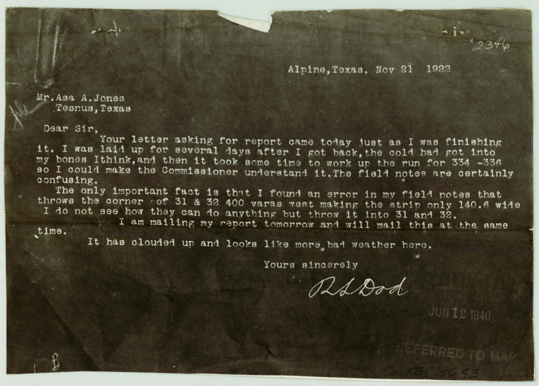
Brewster County Sketch File N-16
[Report and correspondence relating to investigation of the records of the Surveyor's Office to find relative position on the ground of Blocks 334 and 336]
-
Map/Doc
15643
-
Collection
General Map Collection
-
Object Dates
1922/11/21 (Creation Date)
1940/6/17 (File Date)
-
People and Organizations
R.S. Dod (Surveyor/Engineer)
-
Counties
Brewster
-
Subjects
Surveying Sketch File
-
Height x Width
6.2 x 8.7 inches
15.7 x 22.1 cm
-
Medium
photostat, negative
-
Features
Stairway Peak
Iron Mountain
Black Gap
Maravillas [Creek]
Maxon Spring
Part of: General Map Collection
Post Route Map of Texas (Inset 1: Dallas-Fort Worth Area; Inset 2: Texas Panhandle)

Print $40.00
- Digital $50.00
Post Route Map of Texas (Inset 1: Dallas-Fort Worth Area; Inset 2: Texas Panhandle)
1939
Size 56.8 x 39.2 inches
Map/Doc 93699
Upton County Working Sketch 21

Print $20.00
- Digital $50.00
Upton County Working Sketch 21
1950
Size 33.8 x 36.0 inches
Map/Doc 69517

Map of Anderson County

Print $40.00
- Digital $50.00
Map of Anderson County
1895
Size 48.2 x 40.2 inches
Map/Doc 4782
Blanco County Sketch File 42

Print $20.00
- Digital $50.00
Blanco County Sketch File 42
1889
Size 13.5 x 8.8 inches
Map/Doc 14656
[Surveys made in Peters Colony by Thomas Leckie]
![1983, [Surveys made in Peters Colony by Thomas Leckie], General Map Collection](https://historictexasmaps.com/wmedia_w700/maps/1983.tif.jpg)
Print $20.00
- Digital $50.00
[Surveys made in Peters Colony by Thomas Leckie]
1858
Size 22.9 x 16.6 inches
Map/Doc 1983
Outer Continental Shelf Leasing Maps (Texas Offshore Operations)

Print $20.00
- Digital $50.00
Outer Continental Shelf Leasing Maps (Texas Offshore Operations)
Size 17.6 x 13.8 inches
Map/Doc 75844
Comanche County Boundary File 2a

Print $4.00
- Digital $50.00
Comanche County Boundary File 2a
Size 14.3 x 8.8 inches
Map/Doc 51788
Brewster County Sketch File N-28

Print $40.00
- Digital $50.00
Brewster County Sketch File N-28
Size 23.4 x 24.3 inches
Map/Doc 10973
Gillespie County Boundary File 6

Print $2.00
- Digital $50.00
Gillespie County Boundary File 6
Size 11.3 x 8.9 inches
Map/Doc 53770
Burnet County Working Sketch 8

Print $20.00
- Digital $50.00
Burnet County Working Sketch 8
1973
Size 27.2 x 28.0 inches
Map/Doc 67851
Fannin County Rolled Sketch 18F

Print $2.00
- Digital $50.00
Fannin County Rolled Sketch 18F
Size 8.9 x 8.2 inches
Map/Doc 5873
You may also like
Crane County Working Sketch 18

Print $20.00
- Digital $50.00
Crane County Working Sketch 18
1959
Size 37.9 x 18.8 inches
Map/Doc 68295
Flight Mission No. BRA-9M, Frame 78, Jefferson County

Print $20.00
- Digital $50.00
Flight Mission No. BRA-9M, Frame 78, Jefferson County
1953
Size 18.5 x 22.5 inches
Map/Doc 85661
Nueces County Rolled Sketch 25

Print $40.00
- Digital $50.00
Nueces County Rolled Sketch 25
1940
Size 32.2 x 48.4 inches
Map/Doc 9594
Travis County Sketch File 6

Print $8.00
- Digital $50.00
Travis County Sketch File 6
1841
Size 13.8 x 10.9 inches
Map/Doc 38283
Hansford County Working Sketch 8

Print $20.00
- Digital $50.00
Hansford County Working Sketch 8
1971
Size 26.2 x 19.3 inches
Map/Doc 63380
Shackelford County Sketch File 2

Print $4.00
- Digital $50.00
Shackelford County Sketch File 2
1870
Size 9.3 x 9.0 inches
Map/Doc 36572
Van Zandt County Sketch File 9

Print $18.00
- Digital $50.00
Van Zandt County Sketch File 9
1859
Size 12.9 x 8.4 inches
Map/Doc 39384
Stonewall County Working Sketch 11

Print $20.00
- Digital $50.00
Stonewall County Working Sketch 11
1950
Size 23.8 x 33.7 inches
Map/Doc 62318
Lee County Working Sketch 14

Print $20.00
- Digital $50.00
Lee County Working Sketch 14
1981
Size 17.9 x 11.4 inches
Map/Doc 70393
Bowie County Working Sketch 14

Print $20.00
- Digital $50.00
Bowie County Working Sketch 14
1959
Size 25.7 x 43.2 inches
Map/Doc 67418

Flight Mission No. DQN-5K, Frame 147, Calhoun County

Print $20.00
- Digital $50.00
Flight Mission No. DQN-5K, Frame 147, Calhoun County
1953
Size 18.5 x 22.1 inches
Map/Doc 84422