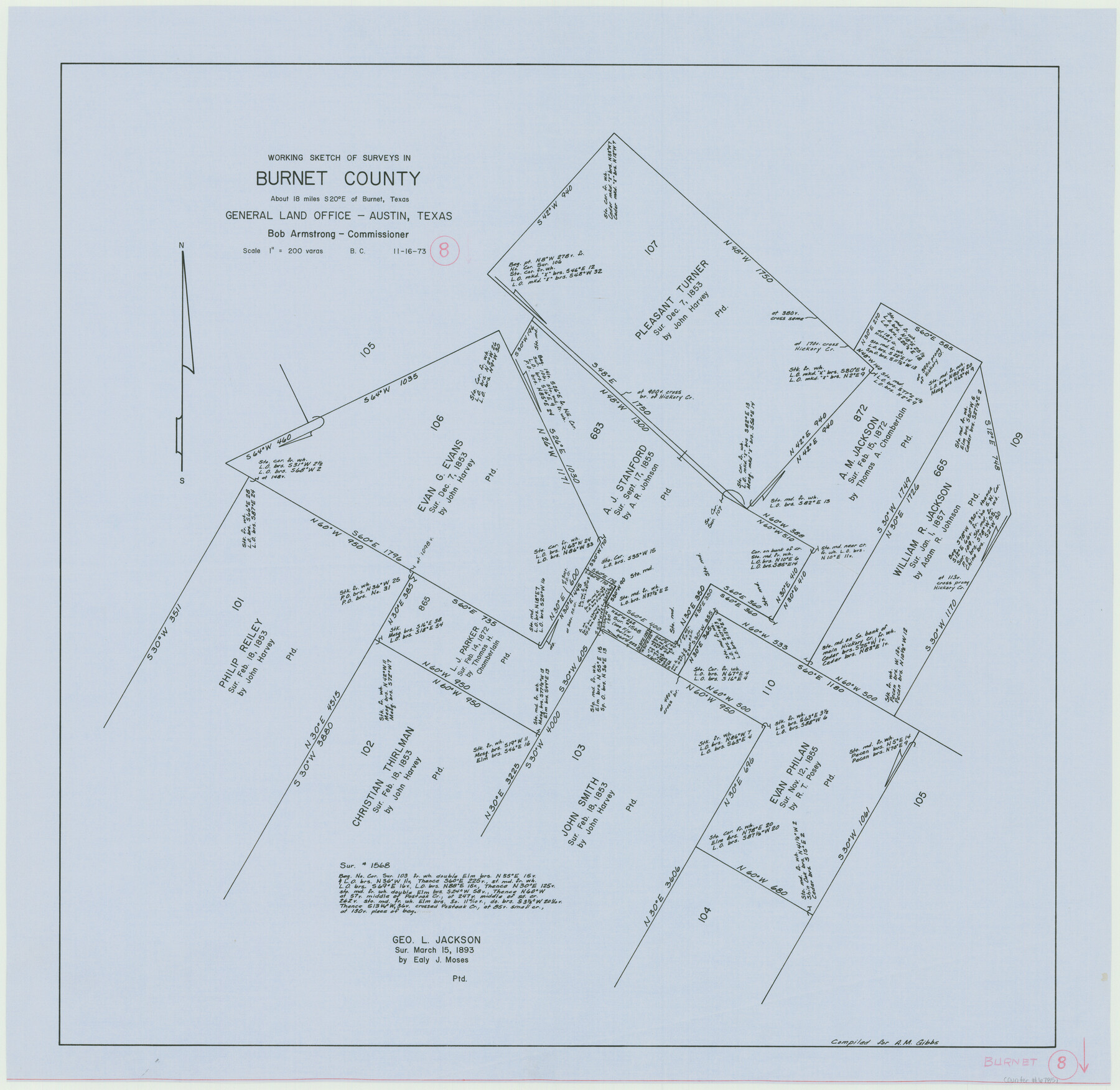
Burnet County Working Sketch 8
-
Map/Doc
67851
-
Collection
General Map Collection
-
Object Dates
11/16/1973 (Creation Date)
-
People and Organizations
Beverly Christian (Draftsman)
-
Counties
Burnet
-
Subjects
Surveying Working Sketch
-
Height x Width
27.2 x 28.0 inches
69.1 x 71.1 cm
-
Scale
1" = 200 varas
Part of: General Map Collection


Flight Mission No. CRK-5P, Frame 127, Refugio County

Print $20.00
- Digital $50.00
Flight Mission No. CRK-5P, Frame 127, Refugio County
1956
Size 18.4 x 22.3 inches
Map/Doc 86930
Uvalde County Working Sketch 10

Print $20.00
- Digital $50.00
Uvalde County Working Sketch 10
1943
Size 30.3 x 38.7 inches
Map/Doc 72080
2017 Official Travel Map, Texas

2017 Official Travel Map, Texas
2017
Size 33.6 x 36.4 inches
Map/Doc 94415
Flight Mission No. DQO-6K, Frame 21, Galveston County

Print $20.00
- Digital $50.00
Flight Mission No. DQO-6K, Frame 21, Galveston County
1952
Size 18.7 x 22.3 inches
Map/Doc 85094
Edwards County Sketch File 30

Print $10.00
- Digital $50.00
Edwards County Sketch File 30
1920
Size 6.5 x 8.9 inches
Map/Doc 21757
Childress County Working Sketch 1

Print $20.00
- Digital $50.00
Childress County Working Sketch 1
1907
Size 18.1 x 15.5 inches
Map/Doc 68017
Trinity County Sketch File 6

Print $6.00
- Digital $50.00
Trinity County Sketch File 6
Size 16.2 x 10.2 inches
Map/Doc 38508
[F. W. & D. C. Ry. Co. Alignment and Right of Way Map, Clay County]
![64722, [F. W. & D. C. Ry. Co. Alignment and Right of Way Map, Clay County], General Map Collection](https://historictexasmaps.com/wmedia_w700/maps/64722-1.tif.jpg)
Print $20.00
- Digital $50.00
[F. W. & D. C. Ry. Co. Alignment and Right of Way Map, Clay County]
1927
Size 18.7 x 11.7 inches
Map/Doc 64722
Flight Mission No. CUG-1P, Frame 77, Kleberg County

Print $20.00
- Digital $50.00
Flight Mission No. CUG-1P, Frame 77, Kleberg County
1956
Size 18.4 x 22.1 inches
Map/Doc 86142
Cameron County Boundary File 2

Print $60.00
- Digital $50.00
Cameron County Boundary File 2
Size 47.8 x 22.1 inches
Map/Doc 51095
You may also like
PSL Field Notes for Block C24 in Loving and Winkler Counties, and Blocks C22 and C23 in Winkler County

PSL Field Notes for Block C24 in Loving and Winkler Counties, and Blocks C22 and C23 in Winkler County
Map/Doc 81677
Coleman County Sketch File 24

Print $6.00
- Digital $50.00
Coleman County Sketch File 24
1872
Size 8.7 x 7.8 inches
Map/Doc 18705
Bandera County Sketch File 26

Print $6.00
- Digital $50.00
Bandera County Sketch File 26
1879
Size 7.7 x 8.3 inches
Map/Doc 14016
Preliminary Sketch of Galveston Bay Indicating Proposed Sites for Light Houses

Print $20.00
Preliminary Sketch of Galveston Bay Indicating Proposed Sites for Light Houses
1851
Size 20.7 x 18.0 inches
Map/Doc 76215
Hutchinson County, 1922

Print $20.00
- Digital $50.00
Hutchinson County, 1922
1922
Size 36.4 x 43.7 inches
Map/Doc 89700
[Surveys in the Travis District along the Colorado River]
![115, [Surveys in the Travis District along the Colorado River], General Map Collection](https://historictexasmaps.com/wmedia_w700/maps/115.tif.jpg)
Print $2.00
- Digital $50.00
[Surveys in the Travis District along the Colorado River]
1840
Size 8.0 x 10.2 inches
Map/Doc 115
Presidio County Sketch File 116

Print $86.00
- Digital $50.00
Presidio County Sketch File 116
1993
Size 11.4 x 8.7 inches
Map/Doc 34842
Hunt County Boundary File 7a

Print $40.00
- Digital $50.00
Hunt County Boundary File 7a
Size 27.9 x 8.5 inches
Map/Doc 55235
Dimmit County Working Sketch 55

Print $20.00
- Digital $50.00
Dimmit County Working Sketch 55
1996
Size 33.7 x 34.3 inches
Map/Doc 68716
Wichita County Working Sketch 9

Print $20.00
- Digital $50.00
Wichita County Working Sketch 9
1920
Size 23.7 x 17.6 inches
Map/Doc 72518
Map of Lee County Texas

Print $20.00
- Digital $50.00
Map of Lee County Texas
1879
Size 26.2 x 18.0 inches
Map/Doc 4578
Kimble County Working Sketch 47

Print $20.00
- Digital $50.00
Kimble County Working Sketch 47
1951
Size 42.9 x 24.3 inches
Map/Doc 70115