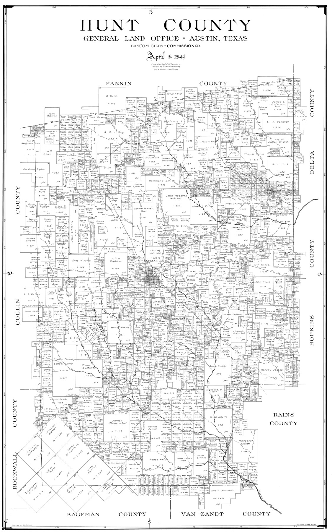
Hunt County
-
Map/Doc
77320
-
Collection
General Map Collection
-
Object Dates
1944/4/4 (Creation Date)
-
People and Organizations
Eltea Armstrong (Draftsman)
William O. Proctor (Compiler)
-
Counties
Hunt
-
Subjects
County
-
Height x Width
41.4 x 25.9 inches
105.2 x 65.8 cm
Part of: General Map Collection
[Surveys in Austin's Colony along the San Antonio Road and the Brazos and Yegua Rivers]
![203, [Surveys in Austin's Colony along the San Antonio Road and the Brazos and Yegua Rivers], General Map Collection](https://historictexasmaps.com/wmedia_w700/maps/203.tif.jpg)
Print $20.00
- Digital $50.00
[Surveys in Austin's Colony along the San Antonio Road and the Brazos and Yegua Rivers]
1831
Size 30.8 x 19.1 inches
Map/Doc 203
Edwards County Working Sketch 123

Print $20.00
- Digital $50.00
Edwards County Working Sketch 123
1976
Size 18.3 x 25.2 inches
Map/Doc 68999
Kimble County Working Sketch 6

Print $20.00
- Digital $50.00
Kimble County Working Sketch 6
1915
Size 24.4 x 26.5 inches
Map/Doc 70074
Hutchinson County Rolled Sketch 44-18

Print $20.00
- Digital $50.00
Hutchinson County Rolled Sketch 44-18
2002
Size 24.0 x 36.0 inches
Map/Doc 77554

Wichita County Sketch File 8

Print $4.00
- Digital $50.00
Wichita County Sketch File 8
1860
Size 11.7 x 8.2 inches
Map/Doc 40048
Young Territory

Print $20.00
- Digital $50.00
Young Territory
1873
Size 45.3 x 42.8 inches
Map/Doc 1988
Parmer County

Print $20.00
- Digital $50.00
Parmer County
1926
Size 43.9 x 35.4 inches
Map/Doc 73259
Presidio County Rolled Sketch 40

Print $20.00
- Digital $50.00
Presidio County Rolled Sketch 40
1907
Size 16.5 x 21.5 inches
Map/Doc 7337
Map of Drum, Oyster & Bastrop Bays & vicinity in Brazoria County showing subdivision for mineral development

Print $20.00
- Digital $50.00
Map of Drum, Oyster & Bastrop Bays & vicinity in Brazoria County showing subdivision for mineral development
Size 36.8 x 47.3 inches
Map/Doc 65808
Liberty County Working Sketch 88

Print $20.00
- Digital $50.00
Liberty County Working Sketch 88
1991
Size 19.6 x 38.8 inches
Map/Doc 70548
Bandera County Sketch File 37

Print $24.00
Bandera County Sketch File 37
Size 11.0 x 8.5 inches
Map/Doc 97248
You may also like

Navarro County Rolled Sketch 4

Print $20.00
- Digital $50.00
Navarro County Rolled Sketch 4
1953
Size 27.1 x 29.8 inches
Map/Doc 6839
Travis County Appraisal District Plat Map 1_0100

Print $20.00
- Digital $50.00
Travis County Appraisal District Plat Map 1_0100
Size 21.6 x 26.4 inches
Map/Doc 94205
Upton County Rolled Sketch 10

Print $20.00
- Digital $50.00
Upton County Rolled Sketch 10
1911
Size 41.2 x 43.0 inches
Map/Doc 10035
Galveston County NRC Article 33.136 Location Key Sheet

Print $20.00
- Digital $50.00
Galveston County NRC Article 33.136 Location Key Sheet
1995
Size 27.0 x 22.0 inches
Map/Doc 83592
[Beaumont, Sour Lake and Western Ry. Right of Way and Alignment - Frisco]
![64117, [Beaumont, Sour Lake and Western Ry. Right of Way and Alignment - Frisco], General Map Collection](https://historictexasmaps.com/wmedia_w700/maps/64117.tif.jpg)
Print $20.00
- Digital $50.00
[Beaumont, Sour Lake and Western Ry. Right of Way and Alignment - Frisco]
1910
Size 20.2 x 45.9 inches
Map/Doc 64117
Jeff Davis County Sketch File 25

Print $32.00
- Digital $50.00
Jeff Davis County Sketch File 25
1886
Size 11.3 x 8.5 inches
Map/Doc 27992
Polk County Boundary File 1

Print $24.00
- Digital $50.00
Polk County Boundary File 1
Size 12.6 x 8.0 inches
Map/Doc 57912
Baylor County Sketch File 23a

Print $10.00
- Digital $50.00
Baylor County Sketch File 23a
1927
Size 14.3 x 8.9 inches
Map/Doc 14204
General Highway Map, Clay County, Texas

Print $20.00
General Highway Map, Clay County, Texas
1961
Size 24.8 x 18.2 inches
Map/Doc 79409
[Right of Way Map, Belton Branch of the M.K.&T. RR.]
![64222, [Right of Way Map, Belton Branch of the M.K.&T. RR.], General Map Collection](https://historictexasmaps.com/wmedia_w700/maps/64222.tif.jpg)
Print $20.00
- Digital $50.00
[Right of Way Map, Belton Branch of the M.K.&T. RR.]
1896
Size 21.9 x 7.4 inches
Map/Doc 64222
Nautical Chart 885-SC Intracoastal Waterway - Ellender to Galveston Bay, Louisiana-Texas

Print $40.00
- Digital $50.00
Nautical Chart 885-SC Intracoastal Waterway - Ellender to Galveston Bay, Louisiana-Texas
1972
Size 16.1 x 59.4 inches
Map/Doc 69836