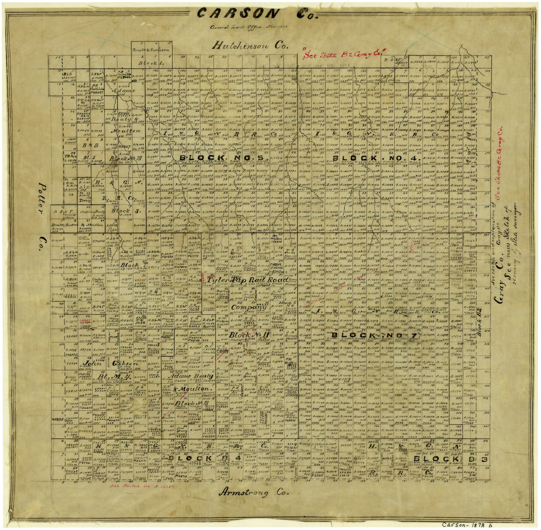
Carson County
-
Map/Doc
3367
-
Collection
General Map Collection
-
Object Dates
11/1878 (Creation Date)
-
People and Organizations
Texas General Land Office (Publisher)
-
Counties
Carson
-
Subjects
County
-
Height x Width
18.2 x 18.6 inches
46.2 x 47.2 cm
-
Features
Paton
Southern Pacific Railroad Company
Panhandle City
McClellands Creek
Part of: General Map Collection
Presidio County Sketch File S

Print $27.00
- Digital $50.00
Presidio County Sketch File S
1917
Size 14.3 x 8.8 inches
Map/Doc 34561
Nueces County Rolled Sketch 60

Print $40.00
- Digital $50.00
Nueces County Rolled Sketch 60
Size 95.5 x 32.3 inches
Map/Doc 9607
Red River County Working Sketch 37

Print $20.00
- Digital $50.00
Red River County Working Sketch 37
1964
Size 31.1 x 34.8 inches
Map/Doc 72020
Sulphur River, Ringo Crossing Sheet

Print $20.00
- Digital $50.00
Sulphur River, Ringo Crossing Sheet
1933
Size 30.5 x 35.9 inches
Map/Doc 65162
National Map Company's Map of Texas showing counties, cities, towns, villages and post offices, steam and electric railways with stations and distance between stations

Print $40.00
- Digital $50.00
National Map Company's Map of Texas showing counties, cities, towns, villages and post offices, steam and electric railways with stations and distance between stations
1920
Size 49.1 x 50.3 inches
Map/Doc 10750
La Salle County

Print $20.00
- Digital $50.00
La Salle County
1886
Size 25.4 x 21.3 inches
Map/Doc 3795
Kimble County Working Sketch 77

Print $20.00
- Digital $50.00
Kimble County Working Sketch 77
1970
Size 25.0 x 36.2 inches
Map/Doc 70145
Ward County Working Sketch 14

Print $20.00
- Digital $50.00
Ward County Working Sketch 14
1947
Size 30.3 x 28.8 inches
Map/Doc 72320

Motley County Sketch File 24 (S)

Print $4.00
- Digital $50.00
Motley County Sketch File 24 (S)
Size 9.2 x 7.1 inches
Map/Doc 32204
Current Miscellaneous File 33

Print $6.00
- Digital $50.00
Current Miscellaneous File 33
1953
Size 10.8 x 8.2 inches
Map/Doc 73939
Kimble County Working Sketch 48

Print $20.00
- Digital $50.00
Kimble County Working Sketch 48
1951
Size 23.2 x 22.1 inches
Map/Doc 70116
You may also like
Presidio County Sketch File 60b

Print $4.00
- Digital $50.00
Presidio County Sketch File 60b
1936
Size 14.4 x 8.8 inches
Map/Doc 34645
Flight Mission No. DQN-7K, Frame 13, Calhoun County

Print $20.00
- Digital $50.00
Flight Mission No. DQN-7K, Frame 13, Calhoun County
1953
Size 18.4 x 22.1 inches
Map/Doc 84464
Comal County Sketch File 14

Print $4.00
- Digital $50.00
Comal County Sketch File 14
1867
Size 7.7 x 7.6 inches
Map/Doc 19029
[Corpus Christi Bay, Padre Island, Mustang Island, Laguna de la Madre, King and Kenedy's Pasture]
![73040, [Corpus Christi Bay, Padre Island, Mustang Island, Laguna de la Madre, King and Kenedy's Pasture], General Map Collection](https://historictexasmaps.com/wmedia_w700/maps/73040.tif.jpg)
Print $20.00
- Digital $50.00
[Corpus Christi Bay, Padre Island, Mustang Island, Laguna de la Madre, King and Kenedy's Pasture]
Size 18.2 x 27.0 inches
Map/Doc 73040
Travis County Sketch File 6

Print $8.00
- Digital $50.00
Travis County Sketch File 6
1841
Size 13.8 x 10.9 inches
Map/Doc 38283
Culberson County Rolled Sketch 65

Print $20.00
- Digital $50.00
Culberson County Rolled Sketch 65
1987
Size 23.7 x 18.8 inches
Map/Doc 5681
Travis County Working Sketch 19

Print $20.00
- Digital $50.00
Travis County Working Sketch 19
1945
Size 32.2 x 40.6 inches
Map/Doc 69403
Flight Mission No. CUG-1P, Frame 159, Kleberg County

Print $20.00
- Digital $50.00
Flight Mission No. CUG-1P, Frame 159, Kleberg County
1956
Size 18.5 x 22.3 inches
Map/Doc 86166
Lynn County Working Sketch Graphic Index

Print $20.00
- Digital $50.00
Lynn County Working Sketch Graphic Index
1961
Size 38.7 x 35.1 inches
Map/Doc 76627
Working Sketch in Pecos Co. [now Val Verde and Terrell Counties] / [Connecting Lines]
![91945, Working Sketch in Pecos Co. [now Val Verde and Terrell Counties] / [Connecting Lines], Twichell Survey Records](https://historictexasmaps.com/wmedia_w700/maps/91945-1.tif.jpg)
Print $20.00
- Digital $50.00
Working Sketch in Pecos Co. [now Val Verde and Terrell Counties] / [Connecting Lines]
Size 29.6 x 21.8 inches
Map/Doc 91945
Zapata County Rolled Sketch 12

Print $40.00
- Digital $50.00
Zapata County Rolled Sketch 12
1917
Size 54.2 x 39.9 inches
Map/Doc 10164
Borden County Sketch File 11

Print $4.00
- Digital $50.00
Borden County Sketch File 11
1892
Size 11.0 x 8.9 inches
Map/Doc 14730