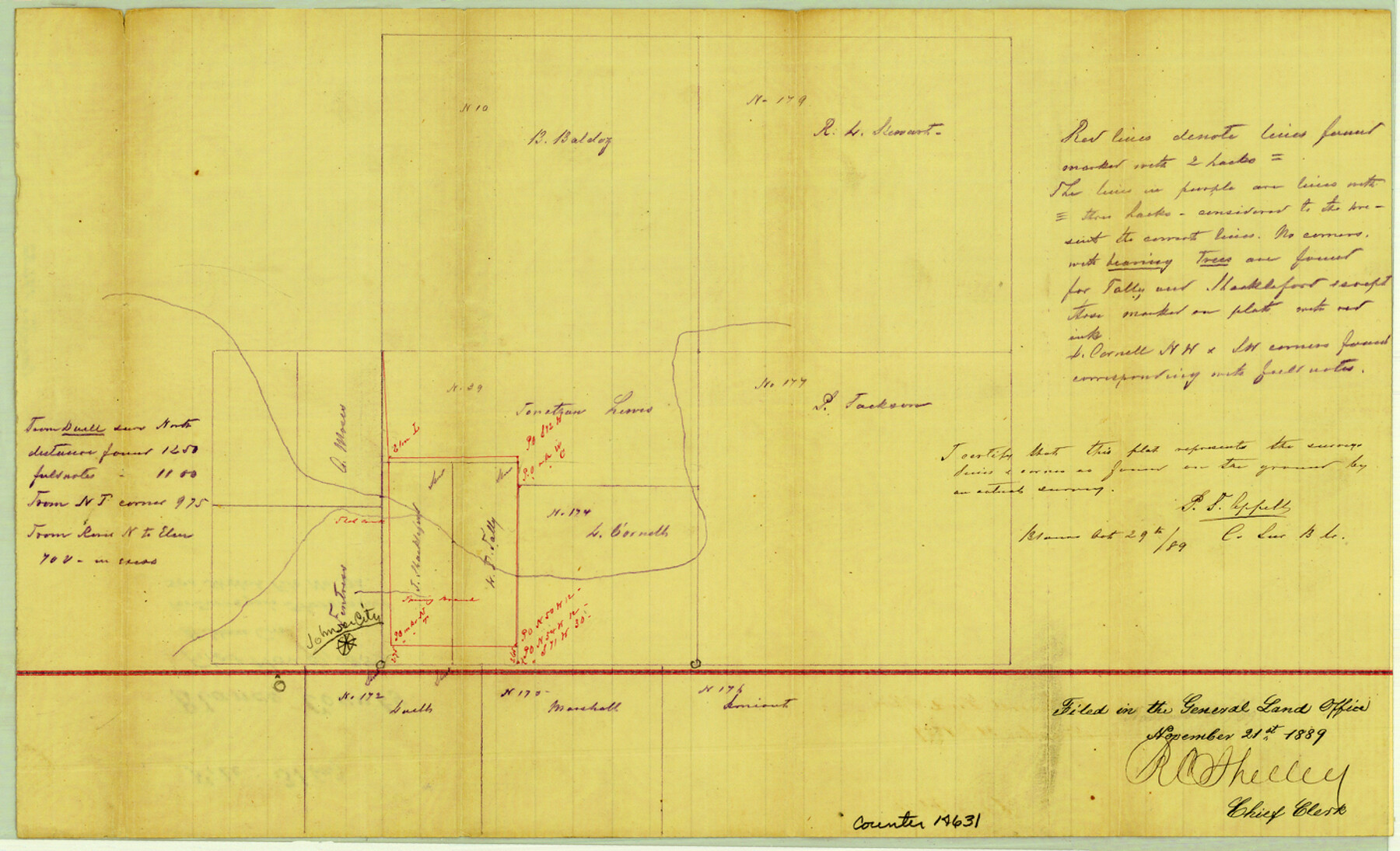
Blanco County Sketch File 31a
[Sketch of area in the vicinity of Johnson City]
-
Map/Doc
14631
-
Collection
General Map Collection
-
Object Dates
1889/10/29 (Creation Date)
1889/11/21 (File Date)
-
People and Organizations
P.F. Appell (Surveyor/Engineer)
-
Counties
Blanco
-
Subjects
Surveying Sketch File
-
Height x Width
8.6 x 14.1 inches
21.8 x 35.8 cm
-
Medium
paper, manuscript
-
Comments
See Blanco County Sketch File 36 (14642) for surveyor's statement.
-
Features
Johnson City
Sled Creek
Spring Branch
Related maps
Blanco County Sketch File 36

Print $8.00
- Digital $50.00
Blanco County Sketch File 36
1889
Size 11.2 x 8.8 inches
Map/Doc 14642
Part of: General Map Collection
Yoakum County Sketch File 13

Print $49.00
- Digital $50.00
Yoakum County Sketch File 13
1898
Size 8.3 x 8.6 inches
Map/Doc 40767
Wichita County Rolled Sketch 18

Print $20.00
- Digital $50.00
Wichita County Rolled Sketch 18
1923
Size 25.7 x 38.0 inches
Map/Doc 8254
Zavala County Working Sketch 8

Print $20.00
- Digital $50.00
Zavala County Working Sketch 8
1949
Size 24.2 x 17.6 inches
Map/Doc 62083
Hidalgo County Sketch File 8

Print $4.00
- Digital $50.00
Hidalgo County Sketch File 8
1890
Size 14.1 x 8.6 inches
Map/Doc 26407
Ward County Working Sketch 13

Print $20.00
- Digital $50.00
Ward County Working Sketch 13
1947
Size 20.0 x 40.6 inches
Map/Doc 72319
Proceedings of The International (Water) Boundary Commission United States and Mexico Treaties of 1884 and 1889, Volume 1

Proceedings of The International (Water) Boundary Commission United States and Mexico Treaties of 1884 and 1889, Volume 1
Map/Doc 83146
Pecos County Sketch File 99

Print $16.00
- Digital $50.00
Pecos County Sketch File 99
Size 11.2 x 8.8 inches
Map/Doc 34004
[Texas & Pacific Railway, Longview to Dallas]
![64098, [Texas & Pacific Railway, Longview to Dallas], General Map Collection](https://historictexasmaps.com/wmedia_w700/maps/64098.tif.jpg)
Print $40.00
- Digital $50.00
[Texas & Pacific Railway, Longview to Dallas]
1873
Size 14.5 x 121.6 inches
Map/Doc 64098
Borden County Rolled Sketch 3

Print $20.00
- Digital $50.00
Borden County Rolled Sketch 3
1908
Size 29.0 x 33.6 inches
Map/Doc 5155
Hood County Sketch File 22a

Print $5.00
- Digital $50.00
Hood County Sketch File 22a
Size 13.7 x 9.3 inches
Map/Doc 26617
Red River County Sketch File 8

Print $22.00
- Digital $50.00
Red River County Sketch File 8
Size 14.7 x 16.8 inches
Map/Doc 35112
Map of The Surveyed Part of Peters Colony Texas

Print $40.00
- Digital $50.00
Map of The Surveyed Part of Peters Colony Texas
1852
Size 56.5 x 41.0 inches
Map/Doc 1966
You may also like
Northeast Part Presidio County

Print $20.00
- Digital $50.00
Northeast Part Presidio County
1973
Size 41.3 x 32.4 inches
Map/Doc 73265
Polk County Working Sketch 19

Print $20.00
- Digital $50.00
Polk County Working Sketch 19
1950
Size 34.0 x 26.5 inches
Map/Doc 71634
[Sketch Showing Exception Number 3 and Exception Number 4]
![91400, [Sketch Showing Exception Number 3 and Exception Number 4], Twichell Survey Records](https://historictexasmaps.com/wmedia_w700/maps/91400-1.tif.jpg)
Print $20.00
- Digital $50.00
[Sketch Showing Exception Number 3 and Exception Number 4]
Size 26.7 x 18.8 inches
Map/Doc 91400
Flight Mission No. DQN-1K, Frame 35, Calhoun County

Print $20.00
- Digital $50.00
Flight Mission No. DQN-1K, Frame 35, Calhoun County
1953
Size 18.5 x 19.0 inches
Map/Doc 84140
Flight Mission No. CRC-2R, Frame 58, Chambers County

Print $20.00
- Digital $50.00
Flight Mission No. CRC-2R, Frame 58, Chambers County
1956
Size 18.8 x 22.6 inches
Map/Doc 84729
Kerr County Sketch File 11

Print $4.00
- Digital $50.00
Kerr County Sketch File 11
1889
Size 14.2 x 8.7 inches
Map/Doc 28879
Brewster County Sketch File 54

Print $4.00
- Digital $50.00
Brewster County Sketch File 54
1963
Size 11.0 x 8.5 inches
Map/Doc 16383
Flight Mission No. DQN-2K, Frame 128, Calhoun County

Print $20.00
- Digital $50.00
Flight Mission No. DQN-2K, Frame 128, Calhoun County
1953
Size 18.6 x 22.3 inches
Map/Doc 84302
Old Miscellaneous File 10

Print $4.00
- Digital $50.00
Old Miscellaneous File 10
Size 9.6 x 8.2 inches
Map/Doc 75435
Nueces County Rolled Sketch 130

Print $20.00
- Digital $50.00
Nueces County Rolled Sketch 130
2000
Size 17.2 x 23.8 inches
Map/Doc 7165
General Highway Map, Irion County, Texas

Print $20.00
General Highway Map, Irion County, Texas
1961
Size 18.2 x 24.5 inches
Map/Doc 79531
Coleman County Sketch File 32

Print $4.00
- Digital $50.00
Coleman County Sketch File 32
Size 12.8 x 8.4 inches
Map/Doc 18723