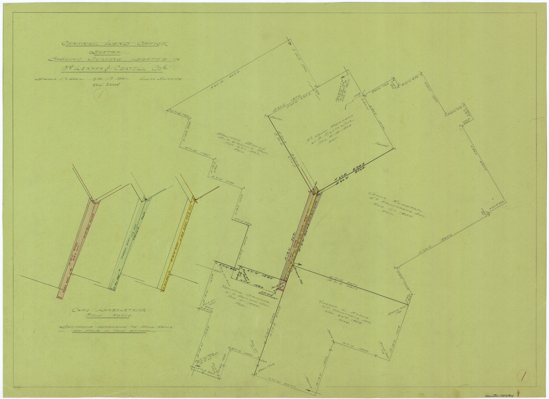
McLennan County Working Sketch 1
-
Map/Doc
70694
-
Collection
General Map Collection
-
Object Dates
1/11/1941 (Creation Date)
-
People and Organizations
William Shirriffs (Draftsman)
-
Counties
McLennan Coryell
-
Subjects
Surveying Working Sketch
-
Height x Width
21.5 x 29.6 inches
54.6 x 75.2 cm
-
Scale
1" = 600 varas
Part of: General Map Collection
Tyler County Sketch File 24

Print $16.00
- Digital $50.00
Tyler County Sketch File 24
1944
Size 11.2 x 9.0 inches
Map/Doc 38681
Harris County Sketch File 33a

Print $20.00
- Digital $50.00
Harris County Sketch File 33a
Size 34.1 x 30.0 inches
Map/Doc 10478
Tom Green County Boundary File 87

Print $10.00
- Digital $50.00
Tom Green County Boundary File 87
Size 9.1 x 4.0 inches
Map/Doc 59393
Franklin County Working Sketch Graphic Index

Print $20.00
- Digital $50.00
Franklin County Working Sketch Graphic Index
1942
Size 40.3 x 16.2 inches
Map/Doc 76546
[Old Coastal Chart showing Brazo Chico, Brazo de Santiago and Rio Bravo del Norte passes with depth readings]
![4661, [Old Coastal Chart showing Brazo Chico, Brazo de Santiago and Rio Bravo del Norte passes with depth readings], General Map Collection](https://historictexasmaps.com/wmedia_w700/maps/4661-1.tif.jpg)
Print $20.00
- Digital $50.00
[Old Coastal Chart showing Brazo Chico, Brazo de Santiago and Rio Bravo del Norte passes with depth readings]
1837
Size 25.7 x 39.3 inches
Map/Doc 4661
Brewster County Rolled Sketch 97

Print $20.00
- Digital $50.00
Brewster County Rolled Sketch 97
1952
Size 31.6 x 30.7 inches
Map/Doc 5254
Hudspeth County Sketch File 31

Print $20.00
- Digital $50.00
Hudspeth County Sketch File 31
1908
Size 18.7 x 17.7 inches
Map/Doc 11805
Flight Mission No. CGI-3N, Frame 51, Cameron County

Print $20.00
- Digital $50.00
Flight Mission No. CGI-3N, Frame 51, Cameron County
1954
Size 18.6 x 22.2 inches
Map/Doc 84557
Chambers County NRC Article 33.136 Location Key Sheet

Print $20.00
- Digital $50.00
Chambers County NRC Article 33.136 Location Key Sheet
1983
Size 24.0 x 44.0 inches
Map/Doc 77014
Willacy County Rolled Sketch 1

Print $121.00
- Digital $50.00
Willacy County Rolled Sketch 1
1956
Size 10.4 x 15.3 inches
Map/Doc 49566
Galveston County Sketch File 43

Print $40.00
- Digital $50.00
Galveston County Sketch File 43
1915
Size 19.4 x 15.1 inches
Map/Doc 11539
Brewster County Rolled Sketch 131

Print $20.00
- Digital $50.00
Brewster County Rolled Sketch 131
1975
Size 30.0 x 32.3 inches
Map/Doc 8522
You may also like
Floyd County Sketch File 10

Print $12.00
- Digital $50.00
Floyd County Sketch File 10
1912
Size 11.6 x 8.9 inches
Map/Doc 22701
Refugio County Working Sketch 8

Print $40.00
- Digital $50.00
Refugio County Working Sketch 8
1940
Size 56.7 x 42.9 inches
Map/Doc 63517
La Salle County Working Sketch 2

Print $20.00
- Digital $50.00
La Salle County Working Sketch 2
1886
Size 17.6 x 16.0 inches
Map/Doc 70303

Reconnoissances of Routes from San Antonio de Bexar, El Paso del Norte &c &c

Print $20.00
- Digital $50.00
Reconnoissances of Routes from San Antonio de Bexar, El Paso del Norte &c &c
1849
Size 26.3 x 38.9 inches
Map/Doc 94853
Terrell County Sketch File 8

Print $6.00
- Digital $50.00
Terrell County Sketch File 8
Size 11.4 x 10.2 inches
Map/Doc 37902
Flight Mission No. BRA-16M, Frame 73, Jefferson County

Print $20.00
- Digital $50.00
Flight Mission No. BRA-16M, Frame 73, Jefferson County
1953
Size 18.7 x 22.3 inches
Map/Doc 85690
Bird's Eye View of the City of Belton, Bell County, Texas

Print $20.00
Bird's Eye View of the City of Belton, Bell County, Texas
1881
Size 18.5 x 23.8 inches
Map/Doc 89074
Fisher County

Print $20.00
- Digital $50.00
Fisher County
1880
Size 29.4 x 25.3 inches
Map/Doc 75772
Milam County Boundary File 5b

Print $20.00
- Digital $50.00
Milam County Boundary File 5b
Size 22.6 x 37.8 inches
Map/Doc 57239
Mills County Boundary File 8

Print $10.00
- Digital $50.00
Mills County Boundary File 8
Size 14.2 x 8.7 inches
Map/Doc 57313
[Location St. L. & S. W. R. R. Through Cherokee County]
![64045, [Location St. L. & S. W. R. R. Through Cherokee County], General Map Collection](https://historictexasmaps.com/wmedia_w700/maps/64045-1.tif.jpg)
Print $40.00
- Digital $50.00
[Location St. L. & S. W. R. R. Through Cherokee County]
Size 38.7 x 76.6 inches
Map/Doc 64045