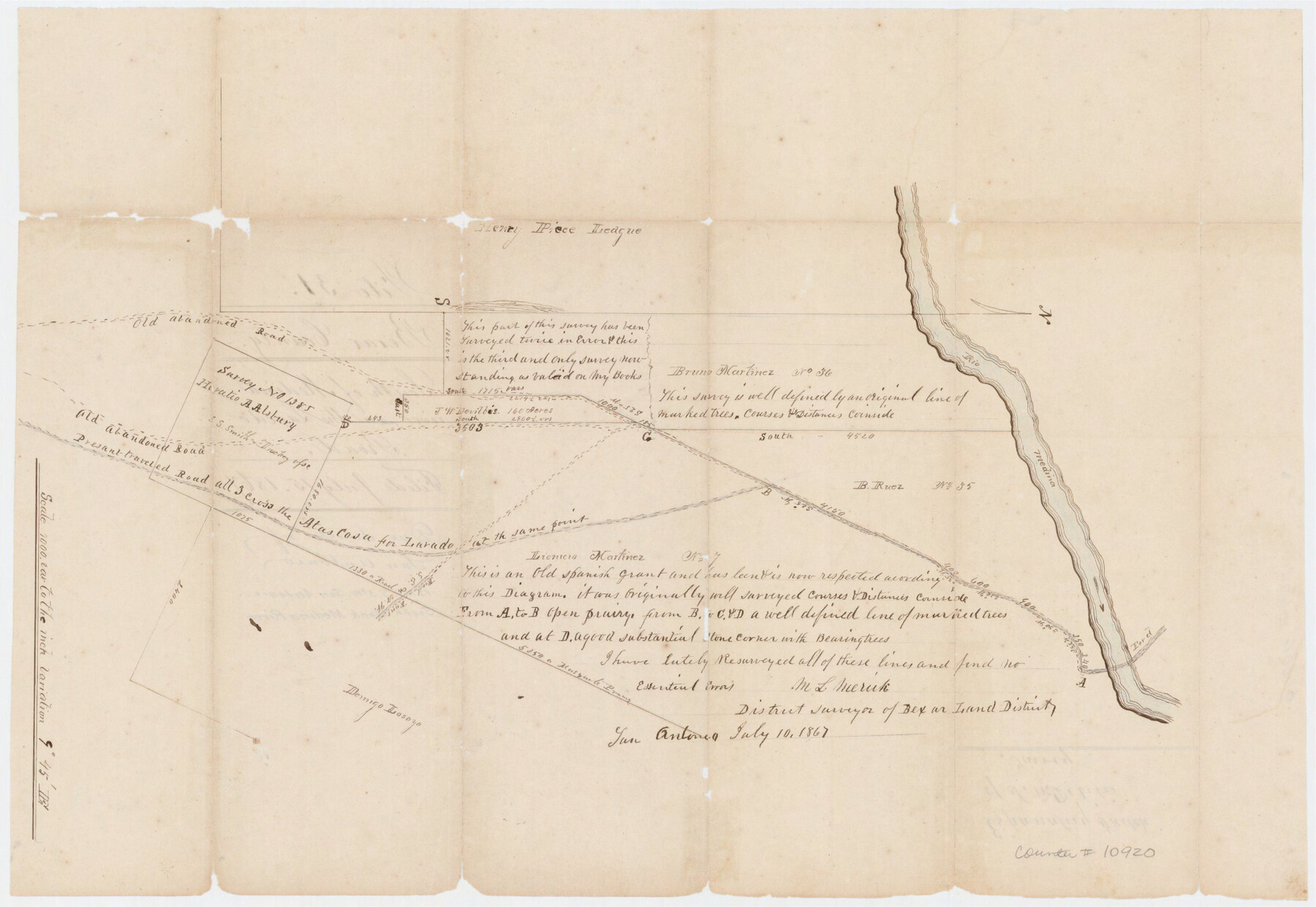
Bexar County Sketch File 31
[Sketch of area south of the Medina River on the Laredo Road, south of San Antonio]
-
Map/Doc
10920
-
Collection
General Map Collection
-
Object Dates
1867/7/10 (Creation Date)
1867/7/15 (File Date)
-
People and Organizations
M.L. Merick (Surveyor/Engineer)
-
Counties
Bexar
-
Subjects
Surveying Sketch File
-
Height x Width
11.3 x 16.4 inches
28.7 x 41.7 cm
-
Medium
paper, manuscript
-
Scale
1" = 1000 varas
-
Comments
Adopted in honor of Frank Santos on his birthday, March 22, 2005, by Leah, Cuatro and Nando. Conservation funded in 2005.
-
Features
Rio Medina
Old Abandoned Road
Present traveled Road Atas Casa for La`redo
Part of: General Map Collection
Crockett County Rolled Sketch 30

Print $20.00
- Digital $50.00
Crockett County Rolled Sketch 30
1934
Size 24.5 x 43.1 inches
Map/Doc 8700
Gaines County Working Sketch 28

Print $20.00
- Digital $50.00
Gaines County Working Sketch 28
1982
Size 20.9 x 24.6 inches
Map/Doc 69328
Austin County

Print $20.00
- Digital $50.00
Austin County
1943
Size 40.1 x 42.5 inches
Map/Doc 73073
Sutton County Sketch File 3

Print $8.00
- Digital $50.00
Sutton County Sketch File 3
Size 12.9 x 8.5 inches
Map/Doc 37353
Crosby County Working Sketch 3

Print $20.00
- Digital $50.00
Crosby County Working Sketch 3
1903
Size 25.7 x 36.0 inches
Map/Doc 68437
Flight Mission No. BRE-2P, Frame 17, Nueces County

Print $20.00
- Digital $50.00
Flight Mission No. BRE-2P, Frame 17, Nueces County
1956
Size 18.2 x 22.1 inches
Map/Doc 86726
Panola County Working Sketch 27

Print $20.00
- Digital $50.00
Panola County Working Sketch 27
1956
Map/Doc 71436
Pecos County Rolled Sketch 151

Print $20.00
- Digital $50.00
Pecos County Rolled Sketch 151
Size 40.6 x 23.6 inches
Map/Doc 7281
Cherokee County Sketch File 12

Print $4.00
- Digital $50.00
Cherokee County Sketch File 12
1860
Size 6.7 x 8.3 inches
Map/Doc 18140
[Map of Matagorda County Showing Abandoned Surveys]
![2066, [Map of Matagorda County Showing Abandoned Surveys], General Map Collection](https://historictexasmaps.com/wmedia_w700/maps/2066.tif.jpg)
Print $40.00
- Digital $50.00
[Map of Matagorda County Showing Abandoned Surveys]
1920
Size 50.3 x 40.2 inches
Map/Doc 2066
Flight Mission No. DCL-6C, Frame 127, Kenedy County

Print $20.00
- Digital $50.00
Flight Mission No. DCL-6C, Frame 127, Kenedy County
1943
Size 18.5 x 22.3 inches
Map/Doc 85957
Brown County Working Sketch 7

Print $20.00
- Digital $50.00
Brown County Working Sketch 7
1954
Size 26.5 x 28.7 inches
Map/Doc 67772
You may also like
Upton County Rolled Sketch 45

Print $20.00
- Digital $50.00
Upton County Rolled Sketch 45
Size 25.1 x 43.8 inches
Map/Doc 8081
Hardin County Sketch File Q-11

Print $20.00
- Digital $50.00
Hardin County Sketch File Q-11
1937
Size 19.9 x 23.8 inches
Map/Doc 11645
Briscoe County Sketch File J

Print $40.00
- Digital $50.00
Briscoe County Sketch File J
1919
Size 19.3 x 32.0 inches
Map/Doc 11007
Hale County Sketch File 28

Print $4.00
- Digital $50.00
Hale County Sketch File 28
1892
Size 11.3 x 9.0 inches
Map/Doc 24776
Borden County Sketch File 8

Print $2.00
- Digital $50.00
Borden County Sketch File 8
1934
Size 11.5 x 7.3 inches
Map/Doc 14727
Flight Mission No. DQO-8K, Frame 131, Galveston County

Print $20.00
- Digital $50.00
Flight Mission No. DQO-8K, Frame 131, Galveston County
1952
Size 18.7 x 22.5 inches
Map/Doc 85196
Motley County Sketch File E1 (S)

Print $8.00
- Digital $50.00
Motley County Sketch File E1 (S)
Size 14.3 x 8.7 inches
Map/Doc 32175
The History of Texas; or, the Emigrants, Farmer's, and Politician's Guide to the Character, Climate, Soil and Productions of that Country; geographically arranged from personal observation and experience.

Print $692.00
- Digital $50.00
The History of Texas; or, the Emigrants, Farmer's, and Politician's Guide to the Character, Climate, Soil and Productions of that Country; geographically arranged from personal observation and experience.
1836
Size 8.1 x 5.3 inches
Map/Doc 93856
University of Texas System University Lands

Print $20.00
- Digital $50.00
University of Texas System University Lands
Size 23.1 x 17.5 inches
Map/Doc 93238
The Republic County of Nacogdoches. Proposed, Late Fall 1837-January 1, 1838

Print $20.00
The Republic County of Nacogdoches. Proposed, Late Fall 1837-January 1, 1838
2020
Size 17.8 x 21.7 inches
Map/Doc 96243
Callahan County

Print $20.00
- Digital $50.00
Callahan County
1918
Size 44.6 x 40.2 inches
Map/Doc 4900
Collin County Rolled Sketch 1

Print $20.00
- Digital $50.00
Collin County Rolled Sketch 1
1953
Size 34.9 x 35.6 inches
Map/Doc 8635