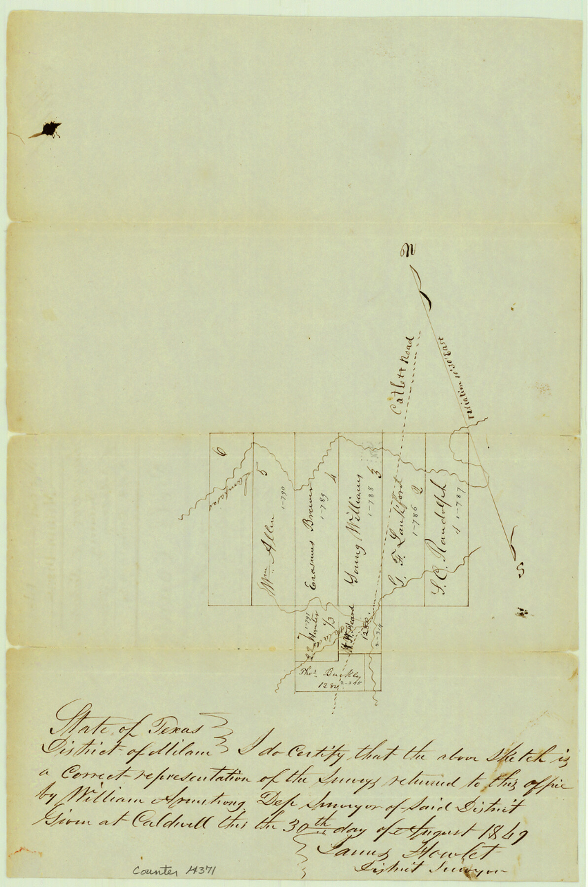
Bell County Sketch File 5
[Sketch of resurvey of Robertsons block of surveys near Lampasas River and Salado Creek]
- 
                          Map/Doc
14371
 - 
                            Collection
General Map Collection
 - 
                            Object Dates
1849/9/19 (File Date)
1849/8/30 (Creation Date)
 - 
                            People and Organizations
James Howlet (Surveyor/Engineer)
 - 
                            Counties
Bell
 - 
                            Subjects
Surveying Sketch File
 - 
                            Height x Width
12.9 x 8.5 inches
32.8 x 21.6 cm
 - 
                            Medium
paper, manuscript
 - 
                            Features
Catlett Road
Lampasas River
Salado River
 
Part of: General Map Collection
            Colorado County Working Sketch 19


                                            Print $20.00                    
                                             -                         Digital $50.00                                    
                Colorado County Working Sketch 19
1958
Size 25.3 x 19.1 inches
                                Map/Doc 68119
            
            Lynn County Rolled Sketch B


                                            Print $20.00                    
                                             -                         Digital $50.00                                    
                Lynn County Rolled Sketch B
1908
Size 27.9 x 33.1 inches
                                Map/Doc 6653
            
            [Surveys in the Milam District]


                                            Print $2.00                    
                                             -                         Digital $50.00                                    
                [Surveys in the Milam District]
1845
Size 9.5 x 6.7 inches
                                Map/Doc 69729
            
            Lubbock County Rolled Sketch 7


                                            Print $20.00                    
                                             -                         Digital $50.00                                    
                Lubbock County Rolled Sketch 7
1944
Size 25.8 x 32.9 inches
                                Map/Doc 6643
            
            Brewster County Working Sketch 109


                                            Print $20.00                    
                                             -                         Digital $50.00                                    
                Brewster County Working Sketch 109
1981
Size 25.2 x 37.0 inches
                                Map/Doc 67709
            
            Revised Map of Matagorda Bay and Vicinity in Matagorda and Calhoun Counties showing subdivision for mineral development


                                            Print $40.00                    
                                             -                         Digital $50.00                                    
                Revised Map of Matagorda Bay and Vicinity in Matagorda and Calhoun Counties showing subdivision for mineral development
1941
Size 44.3 x 60.0 inches
                                Map/Doc 2933
            
            [Surveys along the Leon River and Plum Creek]


                                            Print $2.00                    
                                             -                         Digital $50.00                                    
                [Surveys along the Leon River and Plum Creek]
1846
Size 9.0 x 14.0 inches
                                Map/Doc 69730
            
            [Map of the Fort Worth & Denver City Railway, Hartley County, Texas]


                                            Print $40.00                    
                                             -                         Digital $50.00                                    
                [Map of the Fort Worth & Denver City Railway, Hartley County, Texas]
1887
Size 22.0 x 120.7 inches
                                Map/Doc 64389
            
            Gillespie County Rolled Sketch 10


                                            Print $3.00                    
                                             -                         Digital $50.00                                    
                Gillespie County Rolled Sketch 10
2017
Size 16.1 x 10.7 inches
                                Map/Doc 94413
            
            Comanche County Sketch File 7


                                            Print $6.00                    
                                             -                         Digital $50.00                                    
                Comanche County Sketch File 7
1852
Size 9.9 x 8.1 inches
                                Map/Doc 19063
            
            Upton County Working Sketch 22


                                            Print $40.00                    
                                             -                         Digital $50.00                                    
                Upton County Working Sketch 22
1951
Size 37.5 x 48.7 inches
                                Map/Doc 69518
            
            Presidio County Sketch File 41


                                            Print $6.00                    
                                             -                         Digital $50.00                                    
                Presidio County Sketch File 41
Size 10.3 x 8.3 inches
                                Map/Doc 34515
            You may also like
            Wheeler County Working Sketch 19


                                            Print $20.00                    
                                             -                         Digital $50.00                                    
                Wheeler County Working Sketch 19
1986
Size 33.5 x 31.8 inches
                                Map/Doc 72508
            
            Presidio County Working Sketch 103


                                            Print $20.00                    
                                             -                         Digital $50.00                                    
                Presidio County Working Sketch 103
1980
Size 47.8 x 31.2 inches
                                Map/Doc 71780
            
            Sabine Pass and mouth of the River Sabine in the sea


                                            Print $20.00                    
                                             -                         Digital $50.00                                    
                Sabine Pass and mouth of the River Sabine in the sea
1840
Size 23.8 x 19.0 inches
                                Map/Doc 94268
            
            DeWitt County Sketch File 12


                                            Print $6.00                    
                                             -                         Digital $50.00                                    
                DeWitt County Sketch File 12
1838
Size 10.3 x 8.2 inches
                                Map/Doc 20821
            
            Outer Continental Shelf Leasing Maps (Texas Offshore Operations)


                                            Print $20.00                    
                                             -                         Digital $50.00                                    
                Outer Continental Shelf Leasing Maps (Texas Offshore Operations)
Size 13.5 x 14.2 inches
                                Map/Doc 75843
            
            Rusk County Working Sketch 25


                                            Print $20.00                    
                                             -                         Digital $50.00                                    
                Rusk County Working Sketch 25
1941
Size 39.8 x 25.1 inches
                                Map/Doc 63661
            
            Webb County Working Sketch 36


                                            Print $40.00                    
                                             -                         Digital $50.00                                    
                Webb County Working Sketch 36
1940
Size 38.4 x 67.3 inches
                                Map/Doc 72401
            
            Comal County Rolled Sketch 4


                                            Print $20.00                    
                                             -                         Digital $50.00                                    
                Comal County Rolled Sketch 4
1981
Size 18.8 x 24.5 inches
                                Map/Doc 5539
            
            Duval County Boundary File 3a


                                            Print $8.00                    
                                             -                         Digital $50.00                                    
                Duval County Boundary File 3a
Size 12.7 x 8.0 inches
                                Map/Doc 52726
            
            Right of Way and Track Map, the Missouri, Kansas and Texas Ry. of Texas operated by the Missouri, Kansas and Texas Ry. of Texas, San Antonio Division


                                            Print $40.00                    
                                             -                         Digital $50.00                                    
                Right of Way and Track Map, the Missouri, Kansas and Texas Ry. of Texas operated by the Missouri, Kansas and Texas Ry. of Texas, San Antonio Division
1918
Size 25.3 x 58.3 inches
                                Map/Doc 64579
            
            Flight Mission No. DQN-3K, Frame 50, Calhoun County


                                            Print $20.00                    
                                             -                         Digital $50.00                                    
                Flight Mission No. DQN-3K, Frame 50, Calhoun County
1953
Size 18.4 x 22.2 inches
                                Map/Doc 84351
            
            Crockett County Rolled Sketch 30


                                            Print $20.00                    
                                             -                         Digital $50.00                                    
                Crockett County Rolled Sketch 30
1934
Size 24.5 x 43.1 inches
                                Map/Doc 8700