Bee County Sketch File 29
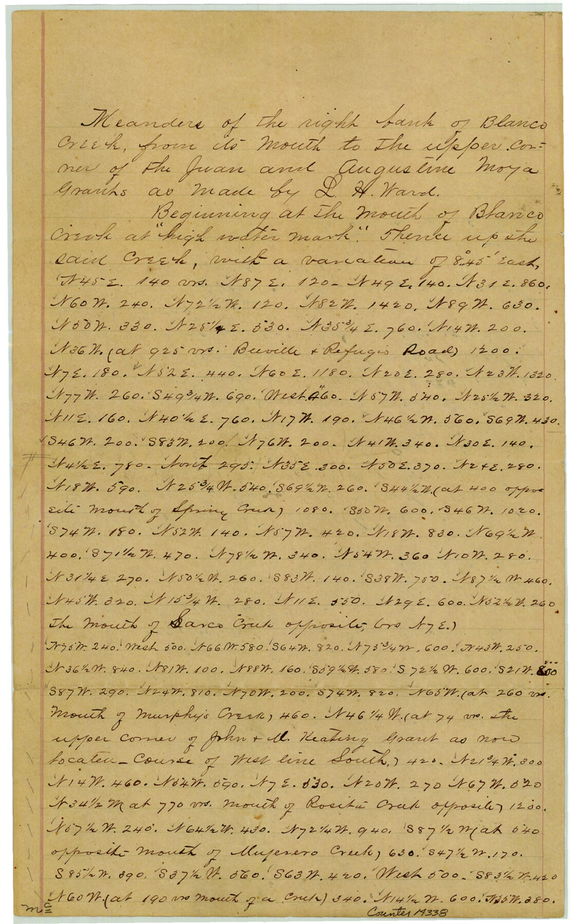
[Field notes of connecting line and meanders of the right bank of Blanco Creek from its mouth to the upper corner of the Juan and Augustine Moya grants]
-
Map/Doc
14338
-
Collection
General Map Collection
-
Object Dates
1887/6/14 (Creation Date)
1887/6/23 (File Date)
1887/6/4 (Survey Date)
-
People and Organizations
R.W. Fenner (Surveyor/Engineer)
John Martin (Chainman)
Joe Burke (Chainman)
-
Counties
Bee
-
Subjects
Surveying Sketch File
-
Height x Width
14.0 x 8.8 inches
35.6 x 22.4 cm
-
Medium
paper, manuscript
-
Features
Blanco Creek
Beeville and Refugio Road
Beeville Road
Refugio Road
Spring Creek
Sarco Creek
Murphy's Creek
Rosita Creek
Mujerero Creek
Part of: General Map Collection
Map of San Patricio County

Print $40.00
- Digital $50.00
Map of San Patricio County
1840
Size 48.7 x 57.2 inches
Map/Doc 77095
Matagorda County Rolled Sketch H & W

Matagorda County Rolled Sketch H & W
1936
Size 27.1 x 41.2 inches
Map/Doc 61776
Flight Mission No. BRA-7M, Frame 73, Jefferson County

Print $20.00
- Digital $50.00
Flight Mission No. BRA-7M, Frame 73, Jefferson County
1953
Size 18.7 x 22.4 inches
Map/Doc 85495
Rockwall County Boundary File 3

Print $22.00
- Digital $50.00
Rockwall County Boundary File 3
Size 14.4 x 8.7 inches
Map/Doc 58391
Baylor County Boundary File 13

Print $44.00
- Digital $50.00
Baylor County Boundary File 13
Size 4.3 x 9.7 inches
Map/Doc 50424
Hale County Sketch File 4

Print $20.00
- Digital $50.00
Hale County Sketch File 4
1891
Size 18.8 x 16.4 inches
Map/Doc 11594
Montgomery County Sketch File 15

Print $4.00
- Digital $50.00
Montgomery County Sketch File 15
1906
Size 9.4 x 8.5 inches
Map/Doc 31817
San Augustine County Sketch File 14

Print $22.00
San Augustine County Sketch File 14
1888
Size 13.2 x 12.6 inches
Map/Doc 35662
Callahan County Rolled Sketch 4

Print $20.00
- Digital $50.00
Callahan County Rolled Sketch 4
1952
Size 20.8 x 30.6 inches
Map/Doc 5381
Intracoastal Waterway in Texas - Corpus Christi to Point Isabel including Arroyo Colorado to Mo. Pac. R.R. Bridge Near Harlingen

Print $20.00
- Digital $50.00
Intracoastal Waterway in Texas - Corpus Christi to Point Isabel including Arroyo Colorado to Mo. Pac. R.R. Bridge Near Harlingen
1933
Size 28.2 x 40.7 inches
Map/Doc 61855
Map of Coleman County

Print $20.00
- Digital $50.00
Map of Coleman County
Size 26.8 x 19.8 inches
Map/Doc 3408
Shelby County Rolled Sketch 3

Print $40.00
- Digital $50.00
Shelby County Rolled Sketch 3
Size 54.2 x 37.0 inches
Map/Doc 9919
You may also like
[West Part of Claude E. Halsell's Survey Section 6 Block A7]
![91063, [West Part of Claude E. Halsell's Survey Section 6 Block A7], Twichell Survey Records](https://historictexasmaps.com/wmedia_w700/maps/91063-1.tif.jpg)
Print $2.00
- Digital $50.00
[West Part of Claude E. Halsell's Survey Section 6 Block A7]
Size 9.2 x 14.7 inches
Map/Doc 91063
Coke County Sketch File 27

Print $26.00
- Digital $50.00
Coke County Sketch File 27
1937
Size 11.2 x 8.7 inches
Map/Doc 18638
Edwards County Working Sketch 16

Print $20.00
- Digital $50.00
Edwards County Working Sketch 16
1929
Size 21.5 x 21.5 inches
Map/Doc 68892

Coke County Rolled Sketch 2

Print $20.00
- Digital $50.00
Coke County Rolled Sketch 2
1947
Size 15.5 x 17.4 inches
Map/Doc 5504
Harris County Working Sketch 94

Print $20.00
- Digital $50.00
Harris County Working Sketch 94
1978
Size 20.9 x 40.2 inches
Map/Doc 65986
Hudspeth County Working Sketch 29

Print $40.00
- Digital $50.00
Hudspeth County Working Sketch 29
1972
Size 31.5 x 55.2 inches
Map/Doc 66311
Delta County Sketch File 1

Print $4.00
- Digital $50.00
Delta County Sketch File 1
1871
Size 12.7 x 8.1 inches
Map/Doc 20666
Copy of Sketch in Nacogdoches Scrip 1392

Print $20.00
- Digital $50.00
Copy of Sketch in Nacogdoches Scrip 1392
1890
Size 25.3 x 14.7 inches
Map/Doc 75780
Victoria County Working Sketch 5

Print $20.00
- Digital $50.00
Victoria County Working Sketch 5
1944
Size 35.2 x 40.8 inches
Map/Doc 72275
Corpus Christi Bay in Nueces County, showing Subdivision for Mineral Development

Print $40.00
- Digital $50.00
Corpus Christi Bay in Nueces County, showing Subdivision for Mineral Development
1950
Size 48.4 x 36.0 inches
Map/Doc 1917
Angelina County Working Sketch 29

Print $20.00
- Digital $50.00
Angelina County Working Sketch 29
1955
Size 24.9 x 23.3 inches
Map/Doc 67111