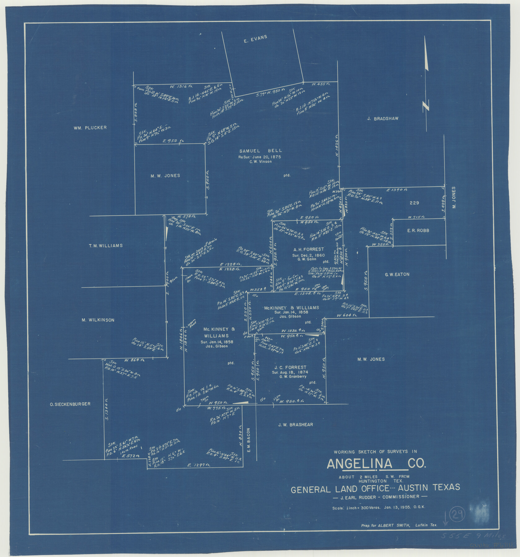
Angelina County Working Sketch 29
-
Map/Doc
67111
-
Collection
General Map Collection
-
Object Dates
1/13/1955 (Creation Date)
-
People and Organizations
J. Earl Rudder (GLO Commissioner)
Otto G. Kurio (Draftsman)
-
Counties
Angelina
-
Subjects
Surveying Working Sketch
-
Height x Width
24.9 x 23.3 inches
63.3 x 59.2 cm
-
Scale
1" = 300 varas
-
Comments
Surveys located about nine miles South 55 degrees East from Lufkin, Texas.
Part of: General Map Collection
Potter County Working Sketch Graphic Index

Print $20.00
- Digital $50.00
Potter County Working Sketch Graphic Index
1960
Size 42.3 x 33.1 inches
Map/Doc 76669
Flight Mission No. DQN-1K, Frame 151, Calhoun County

Print $20.00
- Digital $50.00
Flight Mission No. DQN-1K, Frame 151, Calhoun County
1953
Size 18.6 x 22.3 inches
Map/Doc 84210
Jones County Sketch File 3

Print $4.00
- Digital $50.00
Jones County Sketch File 3
1854
Size 13.3 x 8.0 inches
Map/Doc 28488
Garza County Sketch File 19

Print $20.00
- Digital $50.00
Garza County Sketch File 19
1905
Size 21.8 x 23.0 inches
Map/Doc 11546
Travis County Boundary File 32

Print $5.00
- Digital $50.00
Travis County Boundary File 32
Size 11.8 x 9.4 inches
Map/Doc 59473
Index Map No. 1 - Rio Bravo del Norte section of boundary between the United States & Mexico; agreed upon by the Joint Commission under the Treaty of Guadalupe Hidalgo

Print $20.00
- Digital $50.00
Index Map No. 1 - Rio Bravo del Norte section of boundary between the United States & Mexico; agreed upon by the Joint Commission under the Treaty of Guadalupe Hidalgo
1852
Size 18.3 x 27.5 inches
Map/Doc 72862
Map of the State of Texas

Print $40.00
- Digital $50.00
Map of the State of Texas
1879
Size 102.3 x 56.2 inches
Map/Doc 93384
Wise County Working Sketch 23

Print $20.00
- Digital $50.00
Wise County Working Sketch 23
1981
Size 43.6 x 36.9 inches
Map/Doc 72637
Crockett County Working Sketch 84

Print $40.00
- Digital $50.00
Crockett County Working Sketch 84
1976
Size 49.4 x 26.2 inches
Map/Doc 68417
King County Working Sketch 11

Print $40.00
- Digital $50.00
King County Working Sketch 11
1971
Size 49.7 x 25.0 inches
Map/Doc 70175
Bosque County

Print $40.00
- Digital $50.00
Bosque County
1945
Size 48.8 x 38.7 inches
Map/Doc 95432
Hood County Sketch File 19

Print $11.00
- Digital $50.00
Hood County Sketch File 19
Size 9.0 x 7.9 inches
Map/Doc 26603
You may also like
Flight Mission No. BRA-7M, Frame 16, Jefferson County

Print $20.00
- Digital $50.00
Flight Mission No. BRA-7M, Frame 16, Jefferson County
1953
Size 18.5 x 22.2 inches
Map/Doc 85467
Val Verde County Working Sketch 4

Print $20.00
- Digital $50.00
Val Verde County Working Sketch 4
1906
Size 23.9 x 17.3 inches
Map/Doc 72139
Terrell County Sketch File 15

Print $20.00
- Digital $50.00
Terrell County Sketch File 15
1890
Size 16.0 x 21.6 inches
Map/Doc 12421
Flight Mission No. CRC-6R, Frame 12, Chambers County

Print $20.00
- Digital $50.00
Flight Mission No. CRC-6R, Frame 12, Chambers County
1956
Size 18.7 x 22.3 inches
Map/Doc 84966
Coleman County

Print $40.00
- Digital $50.00
Coleman County
1945
Size 54.7 x 37.1 inches
Map/Doc 73109

Coke County Sketch File 10

Print $6.00
- Digital $50.00
Coke County Sketch File 10
1892
Size 10.7 x 8.1 inches
Map/Doc 18587
Val Verde County Working Sketch 30

Print $20.00
- Digital $50.00
Val Verde County Working Sketch 30
1938
Size 37.9 x 28.5 inches
Map/Doc 72165
Red River County Working Sketch 71

Print $20.00
- Digital $50.00
Red River County Working Sketch 71
1977
Size 17.8 x 28.0 inches
Map/Doc 72054
Flight Mission No. DQN-4K, Frame 8, Calhoun County

Print $20.00
- Digital $50.00
Flight Mission No. DQN-4K, Frame 8, Calhoun County
1953
Size 18.8 x 22.5 inches
Map/Doc 84373
Engineer's Office, Department of the Gulf Map No. 59, Texas prepared by order of Maj. Gen. N. P. Banks under direction of Capt. P. C. Hains, U. S. Engr. & Chief Engr., Dept. of the Gulf

Print $20.00
- Digital $50.00
Engineer's Office, Department of the Gulf Map No. 59, Texas prepared by order of Maj. Gen. N. P. Banks under direction of Capt. P. C. Hains, U. S. Engr. & Chief Engr., Dept. of the Gulf
1865
Size 18.2 x 27.5 inches
Map/Doc 72718
Wise County Sketch File 54

Print $22.00
- Digital $50.00
Wise County Sketch File 54
2012
Size 11.0 x 8.5 inches
Map/Doc 93553