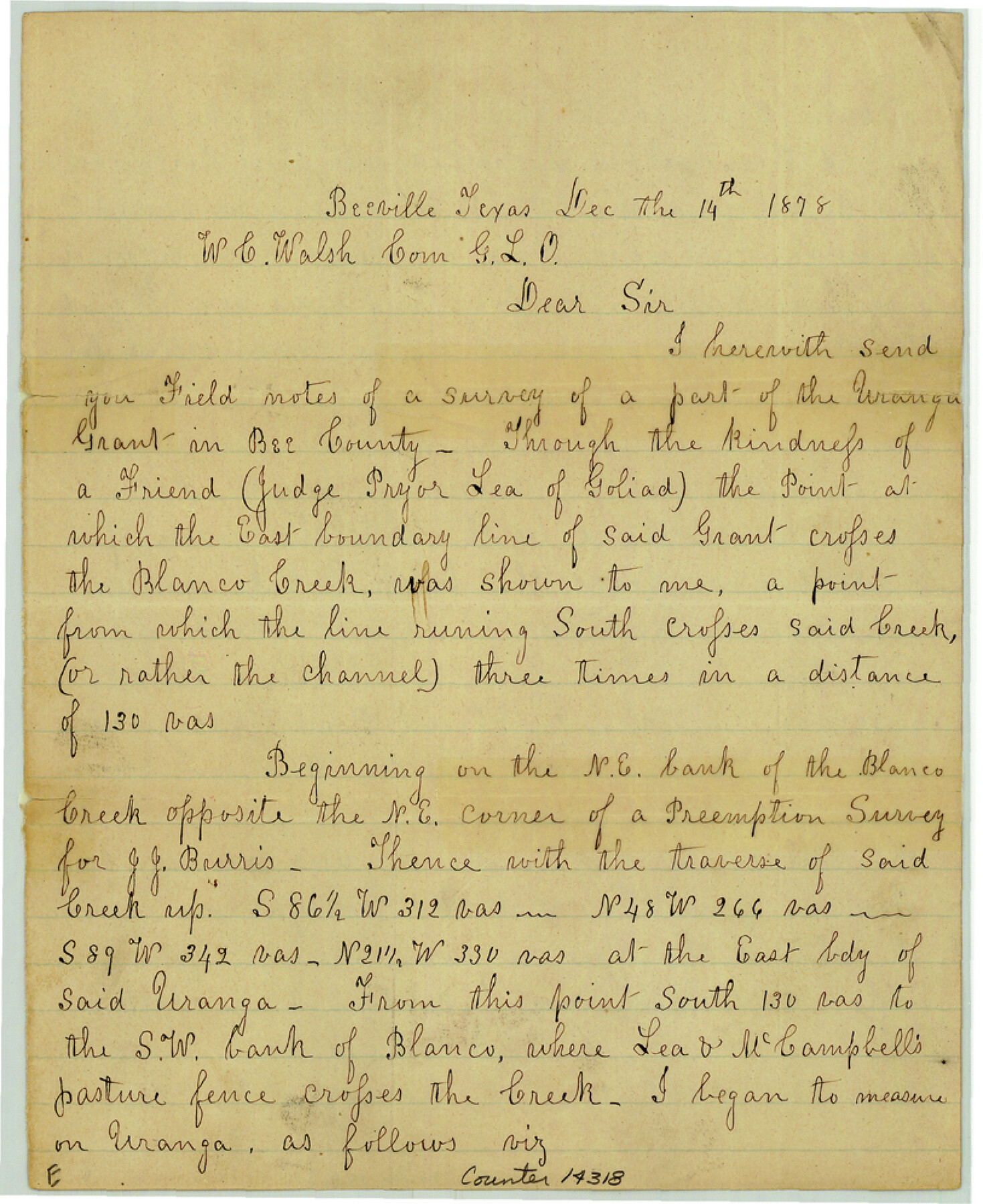
Bee County Sketch File 23
[Field notes of a survey of a part of the Uranga 11 league grant]
-
Map/Doc
14318
-
Collection
General Map Collection
-
Object Dates
1878/12/14 (Creation Date)
1879/1/1 (File Date)
-
People and Organizations
J.F. Fenner (Surveyor/Engineer)
-
Counties
Bee
-
Subjects
Surveying Sketch File
-
Height x Width
10.0 x 8.1 inches
25.4 x 20.6 cm
-
Medium
paper, manuscript
-
Features
Blanco Creek
Medio Creek
Yorktown Road
Helena Road
Part of: General Map Collection
El Paso County Working Sketch 11

Print $40.00
- Digital $50.00
El Paso County Working Sketch 11
1955
Size 49.2 x 43.4 inches
Map/Doc 69033
Jefferson County Sketch File 15b

Print $26.00
- Digital $50.00
Jefferson County Sketch File 15b
Size 17.4 x 33.2 inches
Map/Doc 11869
Kenedy County Working Sketch 4

Print $40.00
- Digital $50.00
Kenedy County Working Sketch 4
1954
Size 60.3 x 37.0 inches
Map/Doc 70006
San Patricio County Rolled Sketch 32

Print $20.00
- Digital $50.00
San Patricio County Rolled Sketch 32
1948
Size 38.8 x 25.0 inches
Map/Doc 7583
Schleicher County Working Sketch 21

Print $20.00
- Digital $50.00
Schleicher County Working Sketch 21
1953
Size 26.6 x 10.8 inches
Map/Doc 63823
Wichita County Working Sketch Graphic Index

Print $20.00
- Digital $50.00
Wichita County Working Sketch Graphic Index
1971
Size 36.7 x 38.5 inches
Map/Doc 76739
Reagan County Sketch File 26

Print $20.00
- Digital $50.00
Reagan County Sketch File 26
1948
Size 16.9 x 28.7 inches
Map/Doc 12223
Upton County Rolled Sketch 58

Print $20.00
- Digital $50.00
Upton County Rolled Sketch 58
Size 39.0 x 35.0 inches
Map/Doc 46125
[Sabine Pass]
![78263, [Sabine Pass], General Map Collection](https://historictexasmaps.com/wmedia_w700/maps/78263.tif.jpg)
Print $20.00
- Digital $50.00
[Sabine Pass]
1916
Size 29.2 x 42.1 inches
Map/Doc 78263
Houston County Working Sketch 35, revised

Print $20.00
- Digital $50.00
Houston County Working Sketch 35, revised
1999
Size 27.8 x 31.6 inches
Map/Doc 66266
Flight Mission No. BQR-4K, Frame 59, Brazoria County

Print $20.00
- Digital $50.00
Flight Mission No. BQR-4K, Frame 59, Brazoria County
1952
Size 18.7 x 22.4 inches
Map/Doc 83992
Flight Mission No. DQO-8K, Frame 139, Galveston County

Print $20.00
- Digital $50.00
Flight Mission No. DQO-8K, Frame 139, Galveston County
1952
Size 18.6 x 22.4 inches
Map/Doc 85201
You may also like


Flight Mission No. DQO-8K, Frame 20, Galveston County

Print $20.00
- Digital $50.00
Flight Mission No. DQO-8K, Frame 20, Galveston County
1952
Size 18.8 x 22.3 inches
Map/Doc 85143
[Sketch Showing Blocks in Hansford County, Texas]
![75819, [Sketch Showing Blocks in Hansford County, Texas], Maddox Collection](https://historictexasmaps.com/wmedia_w700/maps/75819.tif.jpg)
Print $20.00
- Digital $50.00
[Sketch Showing Blocks in Hansford County, Texas]
1890
Size 34.1 x 25.3 inches
Map/Doc 75819
Cameron County Rolled Sketch 5

Print $20.00
- Digital $50.00
Cameron County Rolled Sketch 5
Size 35.8 x 38.8 inches
Map/Doc 8562
[Letter from T. F. Pinckney to W. D. Twichell accompanying sketch showing Blocks 14, 341, and G5]
![93110, [Letter from T. F. Pinckney to W. D. Twichell accompanying sketch showing Blocks 14, 341, and G5], Twichell Survey Records](https://historictexasmaps.com/wmedia_w700/maps/93110-1.tif.jpg)
Print $2.00
- Digital $50.00
[Letter from T. F. Pinckney to W. D. Twichell accompanying sketch showing Blocks 14, 341, and G5]
1911
Size 8.0 x 9.5 inches
Map/Doc 93110
Live Oak County Working Sketch 23

Print $40.00
- Digital $50.00
Live Oak County Working Sketch 23
1976
Size 68.2 x 43.5 inches
Map/Doc 70608
Fractional Township No. 8 South Range No. 19 East of the Indian Meridian, Indian Territory

Print $20.00
- Digital $50.00
Fractional Township No. 8 South Range No. 19 East of the Indian Meridian, Indian Territory
1897
Size 19.1 x 24.2 inches
Map/Doc 75234
Flight Mission No. BRE-2P, Frame 133, Nueces County

Print $20.00
- Digital $50.00
Flight Mission No. BRE-2P, Frame 133, Nueces County
1956
Size 18.5 x 22.5 inches
Map/Doc 86806
[Central Part of San Miguel County]
![92038, [Central Part of San Miguel County], Twichell Survey Records](https://historictexasmaps.com/wmedia_w700/maps/92038-1.tif.jpg)
Print $20.00
- Digital $50.00
[Central Part of San Miguel County]
Size 19.5 x 16.8 inches
Map/Doc 92038
Hartley County Working Sketch 5

Print $20.00
- Digital $50.00
Hartley County Working Sketch 5
1957
Size 46.3 x 28.9 inches
Map/Doc 66055
Map showing the line of the True Southern Pacific Railway and the short link necessary for its completion

Print $20.00
- Digital $50.00
Map showing the line of the True Southern Pacific Railway and the short link necessary for its completion
1881
Size 10.5 x 26.7 inches
Map/Doc 93789