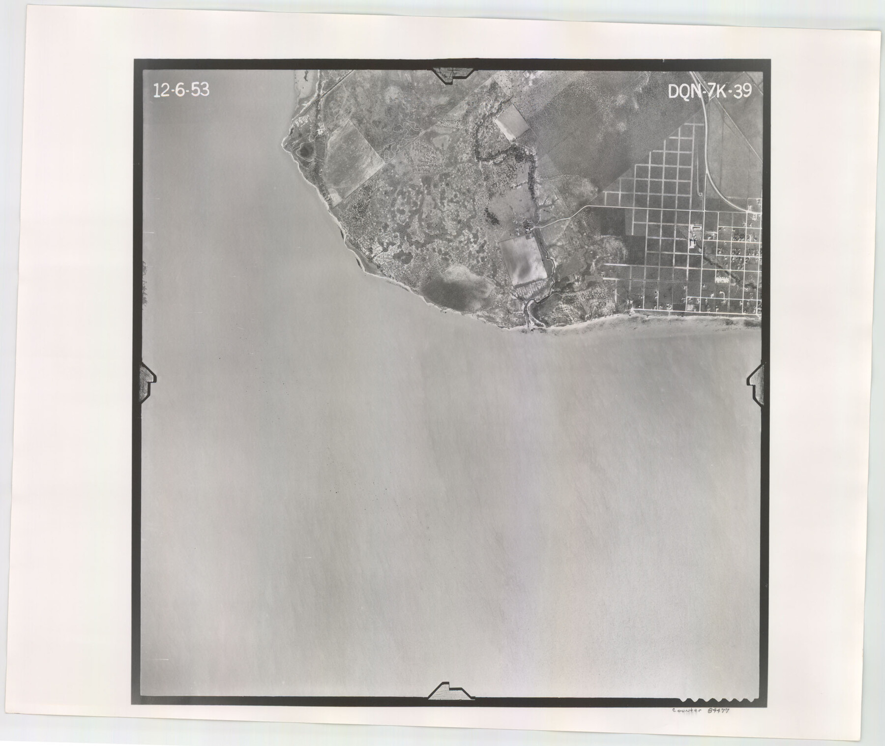
Flight Mission No. DQN-7K, Frame 39, Calhoun County
DQN-7K-39
-
Map/Doc
84477
-
Collection
General Map Collection
-
Object Dates
1953/12/6 (Creation Date)
-
People and Organizations
U. S. Department of Agriculture (Publisher)
-
Counties
Calhoun
-
Subjects
Aerial Photograph
-
Height x Width
19.0 x 22.5 inches
48.3 x 57.2 cm
-
Comments
Flown by Aero Exploration Company of Tulsa, Oklahoma.
Part of: General Map Collection
Flight Mission No. DQO-1K, Frame 119, Galveston County

Print $20.00
- Digital $50.00
Flight Mission No. DQO-1K, Frame 119, Galveston County
1952
Size 19.0 x 22.6 inches
Map/Doc 84997
Travis County Rolled Sketch 4

Print $20.00
- Digital $50.00
Travis County Rolled Sketch 4
1915
Size 19.7 x 35.6 inches
Map/Doc 8010
Armstrong County Sketch File 3

Print $40.00
- Digital $50.00
Armstrong County Sketch File 3
1883
Size 27.4 x 29.4 inches
Map/Doc 10839
Coke County Sketch File 4

Print $46.00
- Digital $50.00
Coke County Sketch File 4
1884
Size 9.2 x 7.7 inches
Map/Doc 18566
Hunt County Sketch File 10

Print $4.00
- Digital $50.00
Hunt County Sketch File 10
1859
Size 12.4 x 8.0 inches
Map/Doc 27100
Duval County Boundary File 3h

Print $4.00
- Digital $50.00
Duval County Boundary File 3h
Size 10.0 x 8.0 inches
Map/Doc 52749
Flight Mission No. CRK-8P, Frame 105, Refugio County

Print $20.00
- Digital $50.00
Flight Mission No. CRK-8P, Frame 105, Refugio County
1956
Size 18.2 x 22.0 inches
Map/Doc 86966
Map of Starr County

Print $40.00
- Digital $50.00
Map of Starr County
1900
Size 51.6 x 25.8 inches
Map/Doc 4046
Aransas County Working Sketch 26

Print $20.00
- Digital $50.00
Aransas County Working Sketch 26
1965
Size 40.8 x 29.4 inches
Map/Doc 67193
Nueces County Rolled Sketch 11

Print $40.00
- Digital $50.00
Nueces County Rolled Sketch 11
Size 43.2 x 56.8 inches
Map/Doc 9586
Falls County Sketch File 21

Print $4.00
- Digital $50.00
Falls County Sketch File 21
1878
Size 8.7 x 9.0 inches
Map/Doc 22394
Val Verde County Working Sketch 13

Print $4.00
- Digital $50.00
Val Verde County Working Sketch 13
Size 24.8 x 25.3 inches
Map/Doc 72148
You may also like
Reeves County Working Sketch 52

Print $40.00
- Digital $50.00
Reeves County Working Sketch 52
1977
Size 60.3 x 41.9 inches
Map/Doc 63495
Dickens County Sketch File 6a

Print $6.00
- Digital $50.00
Dickens County Sketch File 6a
1882
Size 16.5 x 9.4 inches
Map/Doc 20969
Flight Mission No. DIX-3P, Frame 165, Aransas County

Print $20.00
- Digital $50.00
Flight Mission No. DIX-3P, Frame 165, Aransas County
1956
Size 17.8 x 18.4 inches
Map/Doc 83771
Map of Cameron County

Print $20.00
- Digital $50.00
Map of Cameron County
1873
Size 42.2 x 22.5 inches
Map/Doc 3364
[Sketch for Mineral Application 33721 - 33725 Incl. - Padre and Mustang Island]
![2876, [Sketch for Mineral Application 33721 - 33725 Incl. - Padre and Mustang Island], General Map Collection](https://historictexasmaps.com/wmedia_w700/maps/2876.tif.jpg)
Print $20.00
- Digital $50.00
[Sketch for Mineral Application 33721 - 33725 Incl. - Padre and Mustang Island]
1942
Size 29.1 x 23.0 inches
Map/Doc 2876
Bell County Working Sketch Graphic Index

Print $40.00
- Digital $50.00
Bell County Working Sketch Graphic Index
1945
Size 42.6 x 52.8 inches
Map/Doc 76465
Scurry County Working Sketch 9

Print $20.00
- Digital $50.00
Scurry County Working Sketch 9
Size 37.8 x 43.5 inches
Map/Doc 63838
Sutton County Sketch File 43

Print $20.00
- Digital $50.00
Sutton County Sketch File 43
Size 29.1 x 12.4 inches
Map/Doc 12391
Montgomery County Working Sketch 49

Print $20.00
- Digital $50.00
Montgomery County Working Sketch 49
1959
Size 13.8 x 12.0 inches
Map/Doc 71156
Montgomery County Working Sketch 25

Print $40.00
- Digital $50.00
Montgomery County Working Sketch 25
1941
Size 50.0 x 43.7 inches
Map/Doc 71132
[Sketch for Mineral Application 24070 - Smith and Wood Counties, R. A. Tofflemire]
![65643, [Sketch for Mineral Application 24070 - Smith and Wood Counties, R. A. Tofflemire], General Map Collection](https://historictexasmaps.com/wmedia_w700/maps/65643.tif.jpg)
Print $40.00
- Digital $50.00
[Sketch for Mineral Application 24070 - Smith and Wood Counties, R. A. Tofflemire]
1929
Size 42.7 x 226.9 inches
Map/Doc 65643
[Right of Way & Track Map, The Texas & Pacific Ry. Co. Main Line]
![64689, [Right of Way & Track Map, The Texas & Pacific Ry. Co. Main Line], General Map Collection](https://historictexasmaps.com/wmedia_w700/maps/64689.tif.jpg)
Print $20.00
- Digital $50.00
[Right of Way & Track Map, The Texas & Pacific Ry. Co. Main Line]
Size 11.0 x 19.0 inches
Map/Doc 64689