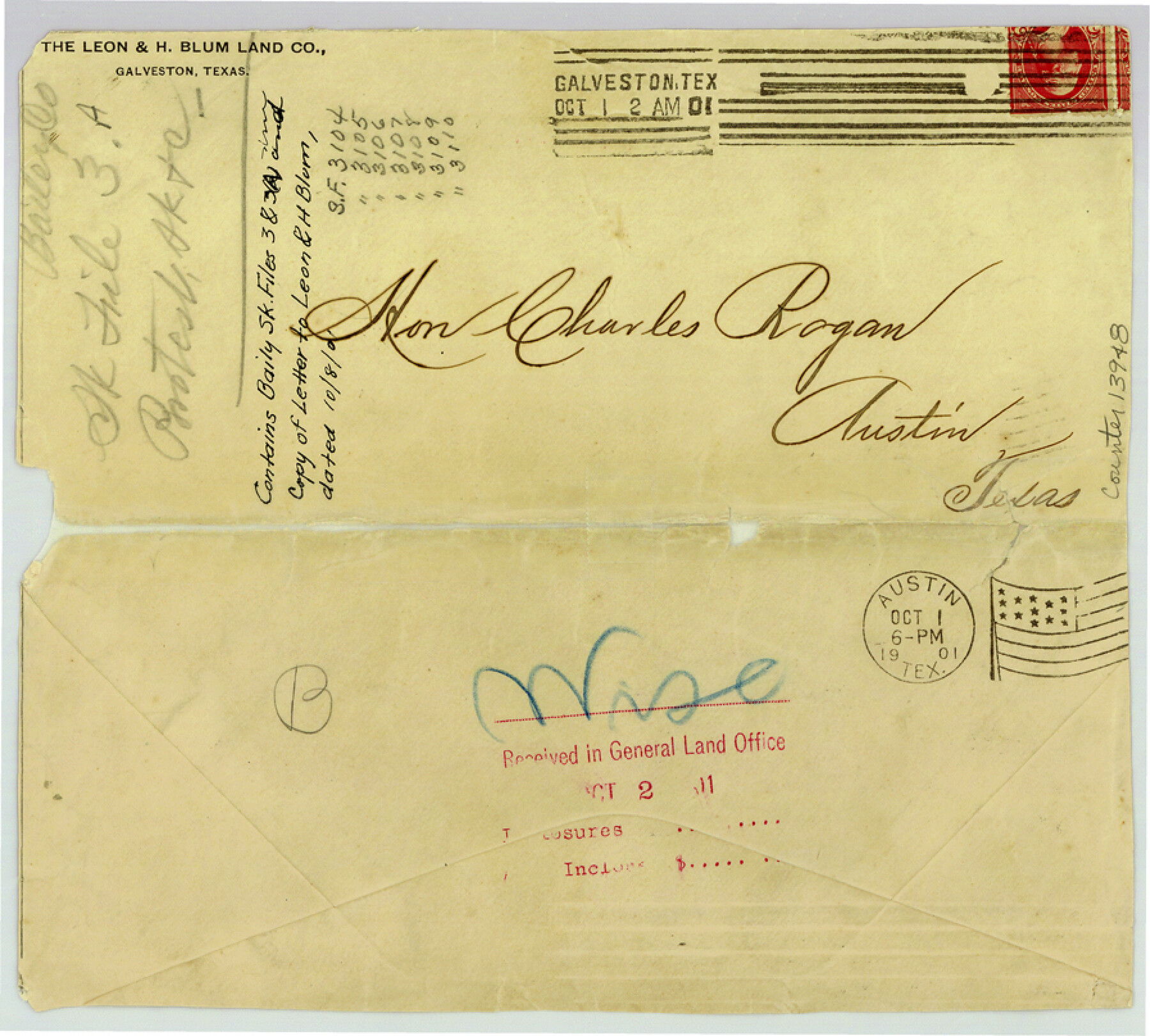
Bailey County Sketch File 3a
[Surveyor's report regarding Blum Ranch]
-
Map/Doc
13948
-
Collection
General Map Collection
-
Object Dates
1901/9/30 (Creation Date)
1901/10/2 (File Date)
-
People and Organizations
Leon Blum (Author)
-
Counties
Bailey
-
Subjects
Surveying Sketch File
-
Height x Width
8.1 x 9.0 inches
20.6 x 22.9 cm
-
Medium
paper, manuscript
-
Features
Blum Ranch
Coyote Lake
Monument Lake
Part of: General Map Collection
Uvalde County Working Sketch 14

Print $20.00
- Digital $50.00
Uvalde County Working Sketch 14
1943
Size 13.5 x 16.0 inches
Map/Doc 72084
Flight Mission No. DAG-24K, Frame 125, Matagorda County

Print $20.00
- Digital $50.00
Flight Mission No. DAG-24K, Frame 125, Matagorda County
1953
Size 18.5 x 22.3 inches
Map/Doc 86543
Hutchinson County Sketch File 24

Print $24.00
- Digital $50.00
Hutchinson County Sketch File 24
1922
Size 7.5 x 8.7 inches
Map/Doc 27256
Fisher County Working Sketch 10

Print $20.00
- Digital $50.00
Fisher County Working Sketch 10
1952
Size 40.5 x 40.7 inches
Map/Doc 69144
Map of Ohio, Michigan, Indiana and Kentucky

Print $20.00
- Digital $50.00
Map of Ohio, Michigan, Indiana and Kentucky
1885
Size 12.2 x 9.0 inches
Map/Doc 93520
Eastland County Sketch File 19

Print $2.00
- Digital $50.00
Eastland County Sketch File 19
1983
Size 14.3 x 9.0 inches
Map/Doc 21608
Burleson County

Print $20.00
- Digital $50.00
Burleson County
1920
Size 40.6 x 45.7 inches
Map/Doc 4896
Ward County Rolled Sketch 22

Print $40.00
- Digital $50.00
Ward County Rolled Sketch 22
1873
Size 69.2 x 18.0 inches
Map/Doc 10110
Sabine and Neches Rivers

Print $20.00
- Digital $50.00
Sabine and Neches Rivers
1987
Size 19.6 x 44.7 inches
Map/Doc 69820
Texas 1849: A Lone Star Rising

Print $20.00
- Digital $50.00
Texas 1849: A Lone Star Rising
2000
Size 40.6 x 40.7 inches
Map/Doc 78270
La Salle County Sketch File 7

Print $22.00
- Digital $50.00
La Salle County Sketch File 7
Size 8.0 x 12.3 inches
Map/Doc 29456
Crockett County Sketch File 54

Print $10.00
- Digital $50.00
Crockett County Sketch File 54
1915
Size 11.3 x 8.9 inches
Map/Doc 19824
You may also like
Sterling County Sketch File 8

Print $20.00
- Digital $50.00
Sterling County Sketch File 8
1916
Size 27.2 x 25.2 inches
Map/Doc 12357
Gulf Intracoastal Waterway, Tex. - Aransas Bay to Corpus Christi Bay - Modified Route of Main Channel/Dredging

Print $20.00
- Digital $50.00
Gulf Intracoastal Waterway, Tex. - Aransas Bay to Corpus Christi Bay - Modified Route of Main Channel/Dredging
1958
Size 31.3 x 42.6 inches
Map/Doc 61894
Maverick County Sketch File 23a

Print $20.00
- Digital $50.00
Maverick County Sketch File 23a
Size 41.0 x 41.1 inches
Map/Doc 10537
Terry County Rolled Sketch 11

Print $20.00
- Digital $50.00
Terry County Rolled Sketch 11
2022
Size 37.1 x 25.1 inches
Map/Doc 97101
Working Sketch Bastrop County

Print $20.00
- Digital $50.00
Working Sketch Bastrop County
1923
Size 17.0 x 13.1 inches
Map/Doc 90145
Stephens County Working Sketch 16

Print $20.00
- Digital $50.00
Stephens County Working Sketch 16
1968
Size 21.4 x 30.4 inches
Map/Doc 63959
Culberson County Working Sketch 77

Print $20.00
- Digital $50.00
Culberson County Working Sketch 77
1975
Size 36.7 x 43.3 inches
Map/Doc 68531
El Paso County Rolled Sketch 57A

Print $40.00
- Digital $50.00
El Paso County Rolled Sketch 57A
1984
Size 49.2 x 39.4 inches
Map/Doc 8879
Hudspeth County Rolled Sketch 66

Print $20.00
- Digital $50.00
Hudspeth County Rolled Sketch 66
1973
Size 11.7 x 18.2 inches
Map/Doc 6263
Runnels County Rolled Sketch C

Print $20.00
- Digital $50.00
Runnels County Rolled Sketch C
1892
Size 16.0 x 21.0 inches
Map/Doc 7541
Red River County Working Sketch 31

Print $20.00
- Digital $50.00
Red River County Working Sketch 31
1962
Size 30.9 x 31.3 inches
Map/Doc 72014
Grayson County Boundary File 1a

Print $120.00
- Digital $50.00
Grayson County Boundary File 1a
Size 69.3 x 11.3 inches
Map/Doc 53928