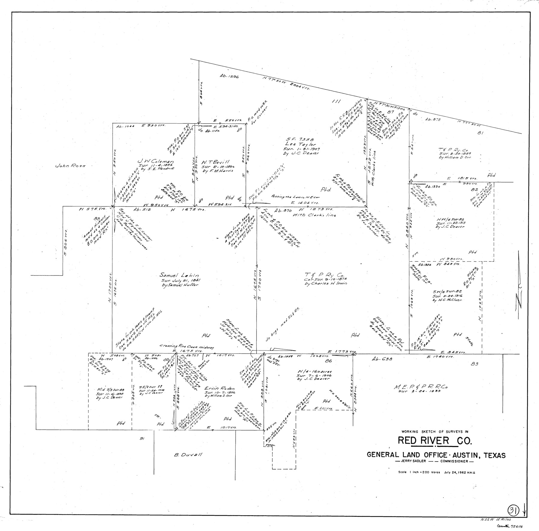
Red River County Working Sketch 31
-
Map/Doc
72014
-
Collection
General Map Collection
-
Object Dates
7/24/1962 (Creation Date)
-
People and Organizations
Herbert H. Ulbricht (Draftsman)
-
Counties
Red River
-
Subjects
Surveying Working Sketch
-
Height x Width
30.9 x 31.3 inches
78.5 x 79.5 cm
-
Scale
1" = 200 varas
Part of: General Map Collection
Upton County Working Sketch 19

Print $40.00
- Digital $50.00
Upton County Working Sketch 19
1949
Size 51.7 x 43.3 inches
Map/Doc 69515
San Jacinto County Rolled Sketch 8

Print $20.00
- Digital $50.00
San Jacinto County Rolled Sketch 8
1940
Size 33.6 x 35.1 inches
Map/Doc 7559
Reagan County Working Sketch 8

Print $20.00
- Digital $50.00
Reagan County Working Sketch 8
1939
Size 37.8 x 23.3 inches
Map/Doc 71848
Brewster County Working Sketch 12

Print $20.00
- Digital $50.00
Brewster County Working Sketch 12
1924
Size 36.9 x 21.4 inches
Map/Doc 67545
Kinney County Sketch File 36

Print $20.00
- Digital $50.00
Kinney County Sketch File 36
1946
Size 19.2 x 22.0 inches
Map/Doc 11949
Township No. 3 South Range No. 19 West of the Indian Meridian

Print $20.00
- Digital $50.00
Township No. 3 South Range No. 19 West of the Indian Meridian
1875
Size 19.2 x 24.5 inches
Map/Doc 75182
Reagan County Rolled Sketch 32

Print $20.00
- Digital $50.00
Reagan County Rolled Sketch 32
Size 46.3 x 38.5 inches
Map/Doc 9827
Kent County Working Sketch 10

Print $20.00
- Digital $50.00
Kent County Working Sketch 10
Size 34.1 x 43.0 inches
Map/Doc 70017
Jackson County Sketch File 1

Print $4.00
- Digital $50.00
Jackson County Sketch File 1
1859
Size 9.9 x 7.6 inches
Map/Doc 27617
[Sketch for Mineral Application 26649-26650 - Sabine River, Harry A. Wolan]
![65565, [Sketch for Mineral Application 26649-26650 - Sabine River, Harry A. Wolan], General Map Collection](https://historictexasmaps.com/wmedia_w700/maps/65565.tif.jpg)
Print $40.00
- Digital $50.00
[Sketch for Mineral Application 26649-26650 - Sabine River, Harry A. Wolan]
Size 36.8 x 71.9 inches
Map/Doc 65565
Flight Mission No. CRC-2R, Frame 63, Chambers County

Print $20.00
- Digital $50.00
Flight Mission No. CRC-2R, Frame 63, Chambers County
1956
Size 18.8 x 22.4 inches
Map/Doc 84734
Flight Mission No. DAG-18K, Frame 75, Matagorda County

Print $20.00
- Digital $50.00
Flight Mission No. DAG-18K, Frame 75, Matagorda County
1952
Size 18.5 x 19.1 inches
Map/Doc 86368
You may also like
Crockett County Sketch File 89

Print $40.00
- Digital $50.00
Crockett County Sketch File 89
1958
Size 12.7 x 13.5 inches
Map/Doc 19916
Chambers County Aerial Photograph Index Sheet 4

Print $20.00
- Digital $50.00
Chambers County Aerial Photograph Index Sheet 4
1956
Size 19.7 x 15.6 inches
Map/Doc 83685
Chambers County Working Sketch 2

Print $20.00
- Digital $50.00
Chambers County Working Sketch 2
1904
Size 34.6 x 25.3 inches
Map/Doc 67985
Presidio County Sketch File 31

Print $20.00
- Digital $50.00
Presidio County Sketch File 31
Size 11.4 x 20.8 inches
Map/Doc 11712

Presidio County Working Sketch 38

Print $20.00
- Digital $50.00
Presidio County Working Sketch 38
1948
Size 35.0 x 22.2 inches
Map/Doc 71715
Leon County Working Sketch 16

Print $20.00
- Digital $50.00
Leon County Working Sketch 16
1958
Size 26.9 x 30.7 inches
Map/Doc 70415
Presidio County Sketch File K

Print $8.00
- Digital $50.00
Presidio County Sketch File K
1907
Size 13.6 x 8.6 inches
Map/Doc 34456
Milam County Working Sketch 2

Print $20.00
- Digital $50.00
Milam County Working Sketch 2
1937
Size 20.2 x 20.5 inches
Map/Doc 71017
Surveys in Austin's Colony along the east fork of Mill Creek

Print $20.00
- Digital $50.00
Surveys in Austin's Colony along the east fork of Mill Creek
1830
Size 23.7 x 12.6 inches
Map/Doc 208
Lynn County Boundary File 10

Print $110.00
- Digital $50.00
Lynn County Boundary File 10
Size 14.3 x 8.7 inches
Map/Doc 56709
General Highway Map, Victoria County, Texas

Print $20.00
General Highway Map, Victoria County, Texas
1961
Size 25.0 x 18.3 inches
Map/Doc 79697