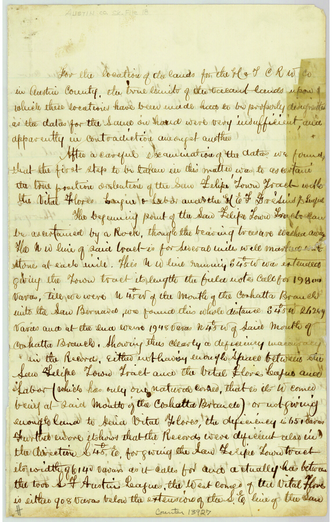
Austin County Sketch File 18
[Report of location of the H. &. T. C. R.R. Co. lands in Austin County]
Austin County Rolled Sketch 2
-
Map/Doc
13927
-
Collection
General Map Collection
-
Counties
Austin
-
Subjects
Surveying Sketch File
-
Height x Width
12.8 x 8.2 inches
32.5 x 20.8 cm
-
Medium
paper, manuscript
-
Features
San Felipe
Coshatta Branch of San Bernard River
San Bernard River
Mill Creek
Arroya [sic] Dulce
Part of: General Map Collection
Flight Mission No. CRK-3P, Frame 178, Refugio County

Print $20.00
- Digital $50.00
Flight Mission No. CRK-3P, Frame 178, Refugio County
1956
Size 18.4 x 22.2 inches
Map/Doc 86925
Flight Mission No. BRA-7M, Frame 208, Jefferson County

Print $20.00
- Digital $50.00
Flight Mission No. BRA-7M, Frame 208, Jefferson County
1953
Size 18.5 x 22.3 inches
Map/Doc 85576
El Paso County Rolled Sketch 53

Print $105.00
- Digital $50.00
El Paso County Rolled Sketch 53
1930
Size 10.1 x 15.3 inches
Map/Doc 44486
Flight Mission No. BRA-16M, Frame 165, Jefferson County

Print $20.00
- Digital $50.00
Flight Mission No. BRA-16M, Frame 165, Jefferson County
1953
Size 18.6 x 22.4 inches
Map/Doc 85763
Controlled Mosaic by Jack Amman Photogrammetric Engineers, Inc - Sheet 48

Print $20.00
- Digital $50.00
Controlled Mosaic by Jack Amman Photogrammetric Engineers, Inc - Sheet 48
1954
Size 20.0 x 24.0 inches
Map/Doc 83507
Webb County Working Sketch 38

Print $20.00
- Digital $50.00
Webb County Working Sketch 38
1941
Size 20.0 x 17.8 inches
Map/Doc 72403
Leon County Working Sketch 24

Print $20.00
- Digital $50.00
Leon County Working Sketch 24
1967
Size 23.3 x 29.0 inches
Map/Doc 70423
Kleberg County Sketch File 2

Print $5.00
- Digital $50.00
Kleberg County Sketch File 2
1934
Size 11.1 x 8.8 inches
Map/Doc 29210
Brazoria County Sketch File 6a

Print $40.00
- Digital $50.00
Brazoria County Sketch File 6a
1862
Size 17.6 x 12.6 inches
Map/Doc 10949
El Paso County Sketch File 14

Print $20.00
- Digital $50.00
El Paso County Sketch File 14
1922
Size 24.0 x 17.2 inches
Map/Doc 11452
Uvalde County

Print $20.00
- Digital $50.00
Uvalde County
1976
Size 43.0 x 46.3 inches
Map/Doc 95660
Armstrong County Working Sketch 7

Print $20.00
- Digital $50.00
Armstrong County Working Sketch 7
Size 18.1 x 16.4 inches
Map/Doc 67238
You may also like
Connected Map of Austin's Colony

Print $40.00
- Digital $50.00
Connected Map of Austin's Colony
1837
Size 93.2 x 43.1 inches
Map/Doc 93376
Lee County Sketch File 10

Print $10.00
- Digital $50.00
Lee County Sketch File 10
2009
Size 11.0 x 8.5 inches
Map/Doc 89289
Map of Gaines County

Print $40.00
- Digital $50.00
Map of Gaines County
1900
Size 59.4 x 37.4 inches
Map/Doc 16832
Plat showing survey of tracts in the C. A. West survey A-337 and the Wm. Standiferd survey A-301 in Bastrop County as surveyed for the Veteran's Land Board

Print $20.00
- Digital $50.00
Plat showing survey of tracts in the C. A. West survey A-337 and the Wm. Standiferd survey A-301 in Bastrop County as surveyed for the Veteran's Land Board
1992
Size 34.9 x 46.8 inches
Map/Doc 61151
Donley County Sketch File 3

Print $6.00
- Digital $50.00
Donley County Sketch File 3
Size 10.8 x 11.9 inches
Map/Doc 21217
Sabine Bank to East Bay including Heald Bank

Print $20.00
- Digital $50.00
Sabine Bank to East Bay including Heald Bank
1925
Size 44.2 x 34.8 inches
Map/Doc 69844
Leon County Rolled Sketch 2

Print $20.00
- Digital $50.00
Leon County Rolled Sketch 2
Size 30.7 x 34.6 inches
Map/Doc 6606
Tom Green County Working Sketch 3

Print $20.00
- Digital $50.00
Tom Green County Working Sketch 3
1933
Size 47.5 x 40.2 inches
Map/Doc 69372
Ward County Working Sketch 25

Print $40.00
- Digital $50.00
Ward County Working Sketch 25
1957
Size 74.3 x 25.6 inches
Map/Doc 72331

Hamilton County Working Sketch 12

Print $20.00
- Digital $50.00
Hamilton County Working Sketch 12
1949
Size 43.9 x 41.7 inches
Map/Doc 63350
Terrell County Sketch File 20

Print $6.00
- Digital $50.00
Terrell County Sketch File 20
1910
Size 10.9 x 12.6 inches
Map/Doc 37946