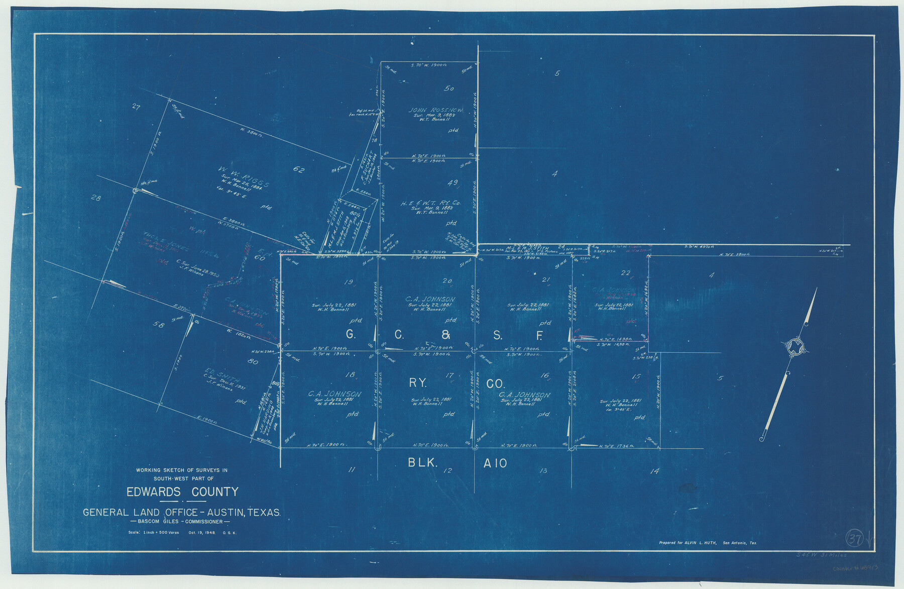
Edwards County Working Sketch 37
-
Map/Doc
68913
-
Collection
General Map Collection
-
Object Dates
10/19/1948 (Creation Date)
-
People and Organizations
Otto G. Kurio (Draftsman)
-
Counties
Edwards
-
Subjects
Surveying Working Sketch
-
Height x Width
23.1 x 35.5 inches
58.7 x 90.2 cm
-
Scale
1" = 500 varas
Part of: General Map Collection
Mosaic composed of aerial photographs - Houston Ship Channel, Tex.

Print $20.00
- Digital $50.00
Mosaic composed of aerial photographs - Houston Ship Channel, Tex.
1923
Size 13.7 x 38.0 inches
Map/Doc 97172
Eastland County Working Sketch 45

Print $20.00
- Digital $50.00
Eastland County Working Sketch 45
1979
Size 31.3 x 43.7 inches
Map/Doc 68826
Matagorda County Sketch File 11

Print $6.00
- Digital $50.00
Matagorda County Sketch File 11
1885
Size 9.7 x 6.2 inches
Map/Doc 30768
Pecos County Working Sketch 78

Print $20.00
- Digital $50.00
Pecos County Working Sketch 78
1960
Size 29.4 x 34.4 inches
Map/Doc 71550
Flight Mission No. BRA-8M, Frame 26, Jefferson County

Print $20.00
- Digital $50.00
Flight Mission No. BRA-8M, Frame 26, Jefferson County
1953
Size 18.6 x 22.3 inches
Map/Doc 85581
Presidio County Working Sketch 78

Print $20.00
- Digital $50.00
Presidio County Working Sketch 78
1965
Size 24.8 x 25.1 inches
Map/Doc 71755
Schleicher County Sketch File 6

Print $4.00
- Digital $50.00
Schleicher County Sketch File 6
Size 8.1 x 8.5 inches
Map/Doc 36472
Coleman County Sketch File 2

Print $2.00
- Digital $50.00
Coleman County Sketch File 2
Size 8.4 x 3.3 inches
Map/Doc 18669
Flight Mission No. DAG-17K, Frame 124, Matagorda County

Print $20.00
- Digital $50.00
Flight Mission No. DAG-17K, Frame 124, Matagorda County
1952
Size 18.6 x 22.3 inches
Map/Doc 86344
Live Oak County

Print $20.00
- Digital $50.00
Live Oak County
1879
Size 27.3 x 21.5 inches
Map/Doc 3821
Flight Mission No. CRE-1R, Frame 125, Jackson County

Print $20.00
- Digital $50.00
Flight Mission No. CRE-1R, Frame 125, Jackson County
1956
Size 17.5 x 22.3 inches
Map/Doc 85336
Colorado County Sketch File 8

Print $4.00
- Digital $50.00
Colorado County Sketch File 8
1861
Size 12.4 x 8.5 inches
Map/Doc 18927
You may also like
Mills County Sketch File 24

Print $20.00
- Digital $50.00
Mills County Sketch File 24
Size 19.2 x 21.0 inches
Map/Doc 12094
Nueces County Rolled Sketch 10

Print $40.00
- Digital $50.00
Nueces County Rolled Sketch 10
Size 31.6 x 55.4 inches
Map/Doc 8350
Map of Marion County

Print $20.00
- Digital $50.00
Map of Marion County
1920
Size 29.2 x 43.2 inches
Map/Doc 66916
Uvalde County Working Sketch 46

Print $20.00
- Digital $50.00
Uvalde County Working Sketch 46
1979
Size 37.1 x 26.3 inches
Map/Doc 72116

Flight Mission No. DAG-19K, Frame 59, Matagorda County

Print $20.00
- Digital $50.00
Flight Mission No. DAG-19K, Frame 59, Matagorda County
1952
Size 18.6 x 22.2 inches
Map/Doc 86386
[H. & G. N. Block 1, G. C. & S. F. Block Z]
![91168, [H. & G. N. Block 1, G. C. & S. F. Block Z], Twichell Survey Records](https://historictexasmaps.com/wmedia_w700/maps/91168-1.tif.jpg)
Print $3.00
- Digital $50.00
[H. & G. N. Block 1, G. C. & S. F. Block Z]
Size 16.8 x 10.5 inches
Map/Doc 91168
Flight Mission No. DAG-17K, Frame 78, Matagorda County

Print $20.00
- Digital $50.00
Flight Mission No. DAG-17K, Frame 78, Matagorda County
1952
Size 18.7 x 22.4 inches
Map/Doc 86337
Crockett County Sketch File 38

Print $20.00
- Digital $50.00
Crockett County Sketch File 38
1887
Size 20.8 x 30.3 inches
Map/Doc 11220
Austin County Sketch File 1

Print $4.00
- Digital $50.00
Austin County Sketch File 1
Size 8.0 x 6.5 inches
Map/Doc 13853
Zavala County Rolled Sketch 25

Print $20.00
- Digital $50.00
Zavala County Rolled Sketch 25
1952
Size 38.4 x 43.4 inches
Map/Doc 10176
[Sketch for Mineral Application 19560 - 19588 - San Bernard River]
![65662, [Sketch for Mineral Application 19560 - 19588 - San Bernard River], General Map Collection](https://historictexasmaps.com/wmedia_w700/maps/65662.tif.jpg)
Print $40.00
- Digital $50.00
[Sketch for Mineral Application 19560 - 19588 - San Bernard River]
Size 31.6 x 73.6 inches
Map/Doc 65662