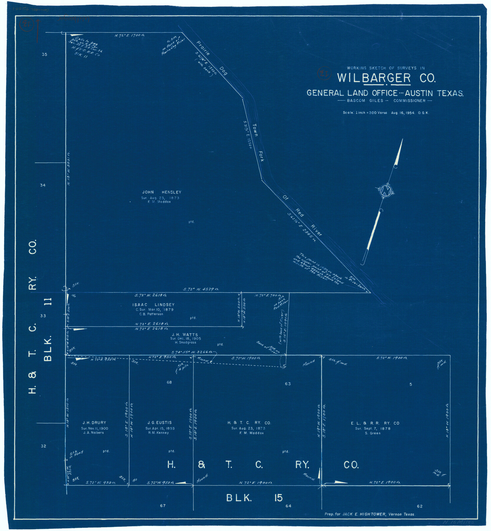
Wilbarger County Working Sketch 13
-
Map/Doc
72551
-
Collection
General Map Collection
-
Object Dates
8/16/1954 (Creation Date)
-
People and Organizations
Otto G. Kurio (Draftsman)
-
Counties
Wilbarger
-
Subjects
Surveying Working Sketch
-
Height x Width
25.9 x 24.0 inches
65.8 x 61.0 cm
-
Scale
1" = 300 varas
Part of: General Map Collection
Lynn County Rolled Sketch A

Print $20.00
- Digital $50.00
Lynn County Rolled Sketch A
1901
Size 33.5 x 34.2 inches
Map/Doc 9471
Map of Milam County

Print $40.00
- Digital $50.00
Map of Milam County
1839
Size 54.5 x 45.9 inches
Map/Doc 3881
Plat showing surveys made for N. Vasquez, Sr. of Casa Piedra, Texas in Block 312, T. C. Ry. Co.

Print $20.00
- Digital $50.00
Plat showing surveys made for N. Vasquez, Sr. of Casa Piedra, Texas in Block 312, T. C. Ry. Co.
1947
Size 16.5 x 22.3 inches
Map/Doc 2062
[Sketch for Mineral Application 33721 - 33725 Incl. - Padre and Mustang Island]
![2868, [Sketch for Mineral Application 33721 - 33725 Incl. - Padre and Mustang Island], General Map Collection](https://historictexasmaps.com/wmedia_w700/maps/2868.tif.jpg)
Print $20.00
- Digital $50.00
[Sketch for Mineral Application 33721 - 33725 Incl. - Padre and Mustang Island]
1942
Size 29.7 x 22.3 inches
Map/Doc 2868

Stonewall County Working Sketch 5

Print $20.00
- Digital $50.00
Stonewall County Working Sketch 5
1927
Size 17.7 x 24.0 inches
Map/Doc 63999
Duval County Sketch File 87

Print $12.00
- Digital $50.00
Duval County Sketch File 87
1991
Size 11.0 x 8.5 inches
Map/Doc 21549
Harris County Sketch File 85

Print $20.00
- Digital $50.00
Harris County Sketch File 85
1894
Size 35.7 x 26.0 inches
Map/Doc 11673
Map of Smith County

Print $20.00
- Digital $50.00
Map of Smith County
1905
Size 29.8 x 29.7 inches
Map/Doc 4041
Pecos County Sketch File 35

Print $4.00
- Digital $50.00
Pecos County Sketch File 35
Size 8.9 x 15.3 inches
Map/Doc 33716
Eastland County Working Sketch 19

Print $20.00
- Digital $50.00
Eastland County Working Sketch 19
1920
Size 15.7 x 16.4 inches
Map/Doc 68800
Guadalupe County Working Sketch 4

Print $20.00
- Digital $50.00
Guadalupe County Working Sketch 4
1939
Size 17.7 x 10.8 inches
Map/Doc 63313
You may also like

Map of Montague County

Print $20.00
- Digital $50.00
Map of Montague County
1868
Size 19.9 x 16.9 inches
Map/Doc 3888
Yoakum County Rolled Sketch 1

Print $20.00
- Digital $50.00
Yoakum County Rolled Sketch 1
1939
Size 40.5 x 37.5 inches
Map/Doc 10162
Val Verde County Sketch File 18

Print $8.00
- Digital $50.00
Val Verde County Sketch File 18
1883
Size 13.1 x 8.4 inches
Map/Doc 39225
Brazoria County, Texas

Print $20.00
- Digital $50.00
Brazoria County, Texas
1877
Size 24.7 x 21.7 inches
Map/Doc 425
Live Oak County Working Sketch 30

Print $20.00
- Digital $50.00
Live Oak County Working Sketch 30
1988
Size 19.0 x 25.9 inches
Map/Doc 70615

Kimble County Sketch File 27

Print $6.00
- Digital $50.00
Kimble County Sketch File 27
1913
Size 11.4 x 9.7 inches
Map/Doc 28971
Crockett County Working Sketch 100

Print $20.00
- Digital $50.00
Crockett County Working Sketch 100
1980
Size 35.6 x 39.9 inches
Map/Doc 68433
Map of Tom Green County

Print $20.00
- Digital $50.00
Map of Tom Green County
1892
Size 43.8 x 42.6 inches
Map/Doc 16898
Carte des Côtes du Golfe du Mexique compris entre la Pointe Sud de la Presqu'Ile de la Floride et la Pointe Nord de la Presqu'Ile d'Yucatan

Print $20.00
- Digital $50.00
Carte des Côtes du Golfe du Mexique compris entre la Pointe Sud de la Presqu'Ile de la Floride et la Pointe Nord de la Presqu'Ile d'Yucatan
1800
Size 26.0 x 37.5 inches
Map/Doc 95322
