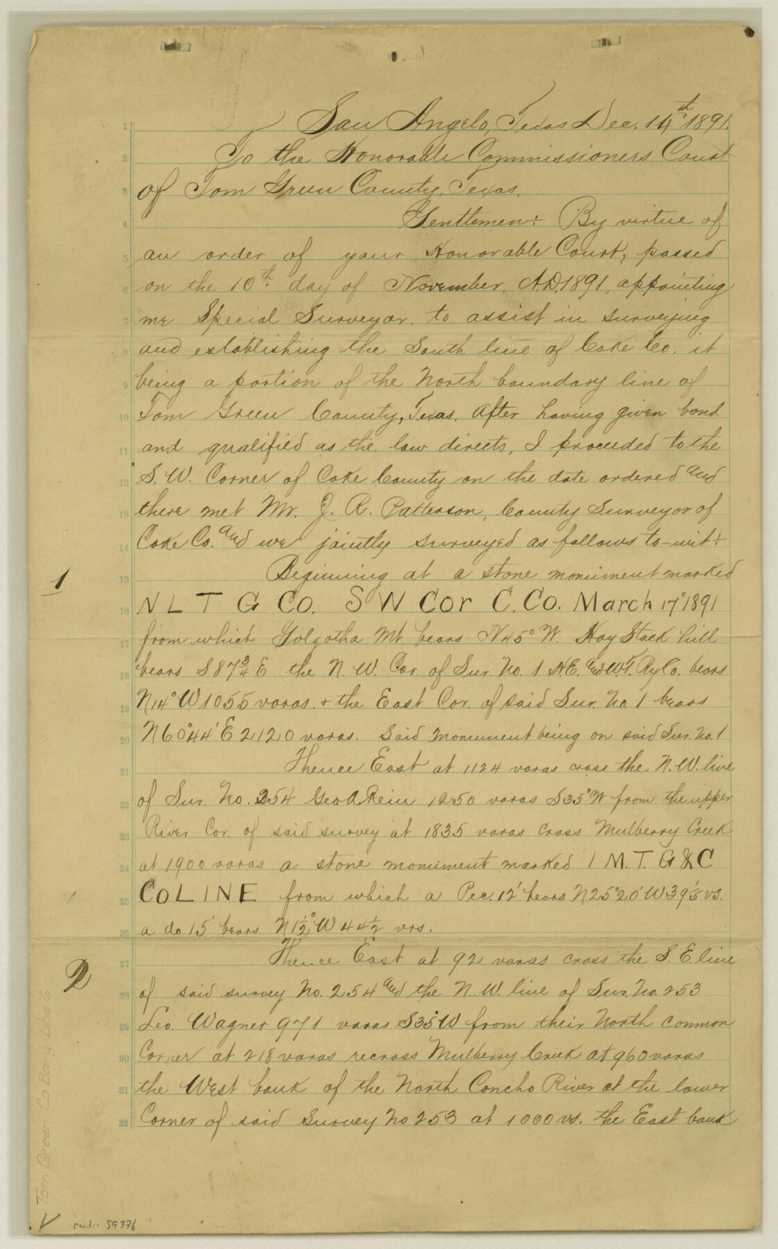
Tom Green County Boundary File 6
No. Boundary Line Tom Green Co.
-
Map/Doc
59376
-
Collection
General Map Collection
-
Counties
Tom Green
-
Subjects
County Boundaries
-
Height x Width
14.5 x 9.0 inches
36.8 x 22.9 cm
Part of: General Map Collection

Gulf Coast of the United States, Key West to Rio Grande

Print $20.00
- Digital $50.00
Gulf Coast of the United States, Key West to Rio Grande
1892
Size 27.5 x 18.4 inches
Map/Doc 72672
Victoria County Rolled Sketch 3

Print $20.00
- Digital $50.00
Victoria County Rolled Sketch 3
1950
Size 41.9 x 37.8 inches
Map/Doc 10094

Old Miscellaneous File 31

Print $8.00
- Digital $50.00
Old Miscellaneous File 31
1845
Size 8.6 x 5.6 inches
Map/Doc 75748
Controlled Mosaic by Jack Amman Photogrammetric Engineers, Inc - Sheet 18

Print $20.00
- Digital $50.00
Controlled Mosaic by Jack Amman Photogrammetric Engineers, Inc - Sheet 18
1954
Size 20.0 x 24.0 inches
Map/Doc 83462
Roberts County Rolled Sketch 3

Print $40.00
- Digital $50.00
Roberts County Rolled Sketch 3
Size 38.0 x 49.7 inches
Map/Doc 8356
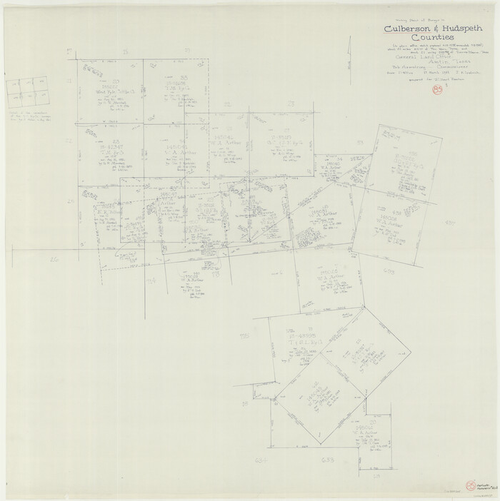
Culberson County Working Sketch 85
Print $20.00
- Digital $50.00
Culberson County Working Sketch 85
1981
Size 37.0 x 36.9 inches
Map/Doc 68539
University Land, Winkler-Andrews-Gaines-Dawson-Martin Counties

Print $40.00
- Digital $50.00
University Land, Winkler-Andrews-Gaines-Dawson-Martin Counties
Size 42.8 x 53.2 inches
Map/Doc 62931
Flight Mission No. DAG-24K, Frame 139, Matagorda County

Print $20.00
- Digital $50.00
Flight Mission No. DAG-24K, Frame 139, Matagorda County
1953
Size 18.5 x 22.3 inches
Map/Doc 86557

South Part Brewster Co.

Print $40.00
- Digital $50.00
South Part Brewster Co.
1910
Size 32.0 x 49.7 inches
Map/Doc 66728
You may also like
A Map of Dallas County

Print $20.00
- Digital $50.00
A Map of Dallas County
1855
Size 18.4 x 18.8 inches
Map/Doc 3465
Childress Co.

Print $20.00
- Digital $50.00
Childress Co.
1978
Size 46.2 x 35.0 inches
Map/Doc 73105
Upton County Sketch File 43

Print $22.00
- Digital $50.00
Upton County Sketch File 43
1988
Size 11.4 x 8.8 inches
Map/Doc 38920
Chambers County Rolled Sketch 12C

Print $97.00
- Digital $50.00
Chambers County Rolled Sketch 12C
Size 10.0 x 15.2 inches
Map/Doc 43939
Flight Mission No. CRK-3P, Frame 175, Refugio County

Print $20.00
- Digital $50.00
Flight Mission No. CRK-3P, Frame 175, Refugio County
1956
Size 18.6 x 21.7 inches
Map/Doc 86922
Reeves County Sketch File 10

Print $20.00
- Digital $50.00
Reeves County Sketch File 10
Size 17.0 x 32.0 inches
Map/Doc 12244
Leon County Rolled Sketch 6

Print $20.00
- Digital $50.00
Leon County Rolled Sketch 6
1951
Size 31.7 x 37.1 inches
Map/Doc 6596
Bexar County Sketch File 9

Print $4.00
- Digital $50.00
Bexar County Sketch File 9
1853
Size 8.2 x 13.2 inches
Map/Doc 14479
Duval County Rolled Sketch HD

Print $20.00
- Digital $50.00
Duval County Rolled Sketch HD
1939
Size 22.8 x 32.8 inches
Map/Doc 5767
Medina County Sketch File 8

Print $4.00
- Digital $50.00
Medina County Sketch File 8
Size 9.3 x 6.6 inches
Map/Doc 31456
Hockley County Boundary File 5

Print $42.00
- Digital $50.00
Hockley County Boundary File 5
Size 6.8 x 5.8 inches
Map/Doc 54829
Calhoun County NRC Article 33.136 Location Key Sheet

Print $20.00
- Digital $50.00
Calhoun County NRC Article 33.136 Location Key Sheet
1973
Size 27.0 x 23.0 inches
Map/Doc 87907