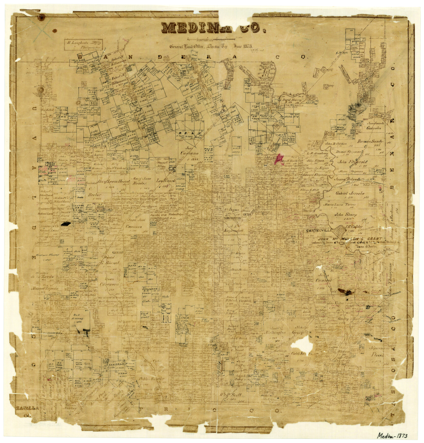
Medina County
-
Map/Doc
3868
-
Collection
General Map Collection
-
Object Dates
1873 (Creation Date)
-
People and Organizations
Texas General Land Office (Publisher)
A. Gomert (Draftsman)
Herman Lungkwitz (Draftsman)
-
Counties
Medina
-
Subjects
County
-
Height x Width
21.9 x 21.0 inches
55.6 x 53.3 cm
-
Features
Rosales Creek
General Woll's Road
Parker's Creek
D'Hanis
Live Oak Slough
Lucky's Creek
Quihi Creek
Hondo Creek
Chacon Creek
West Prong [of Hondo Creek]
Rio Grande Road
Presidio Road
Presidio and Rio Grande Road
Sous Creek
S[an] Antonio Road
Castroville
Potranco Creek
Quihi
Pilot Knob
Pecan Creek
Black Creek
Rocky Creek
Atascosa River
Fork of Atascosa Creek
Madera Creek
Upper Presidio Road
Seco Creek
Deer Creek
Rio Frio
Pi[ta] Road
Old Vandesberg
New Vandesberg
Col. Frank's Road adopted as County Road
San Geronimo Creek
Rapid Creek
Cascade Creek
High Mountain
Ward's Creek
Williams Creek
Commissioner's Creek
Arroyo Hondo
[ ]bery Creek
Ward's Prong
Rio Medina
Don Pedro Spring
Gallagher Spring
Cypress Creek
Middle Prong of Hondo Creek
Abond.'d. Mormon Settlement under Col. White
Cold Creek
[Road] from Castroville to Bandera
Castroville Road
Bandera Road
[Road] from Castroville over Quihi to Bandera
Quihi Road
Middle Prong of Ward's Creek
East Prong [of Ward's Creek]
[Road] from Castroville, Quihi and Vandesberg to the Upper Hondo
Vandesberg Road
[Road] to Upper Hondo
Round Mountain
Arroyo Saco [sic]
Vandesberg
Road to Vandersberg
New Fountain
Part of: General Map Collection
Hardeman County Aerial Photograph Index Sheet 5

Print $20.00
- Digital $50.00
Hardeman County Aerial Photograph Index Sheet 5
1950
Size 19.0 x 16.9 inches
Map/Doc 83701
[Surveys between Big Keechi Creek and the Trinity River]
![69753, [Surveys between Big Keechi Creek and the Trinity River], General Map Collection](https://historictexasmaps.com/wmedia_w700/maps/69753.tif.jpg)
Print $2.00
- Digital $50.00
[Surveys between Big Keechi Creek and the Trinity River]
Size 10.1 x 7.3 inches
Map/Doc 69753

Field Notes of Surveys in Travis District (Callahan, Coleman, and Runnels Counties)

Field Notes of Surveys in Travis District (Callahan, Coleman, and Runnels Counties)
Map/Doc 81675
Reagan County Rolled Sketch 2

Print $40.00
- Digital $50.00
Reagan County Rolled Sketch 2
1903
Size 52.4 x 37.3 inches
Map/Doc 10621
Lamb County Boundary File 1e

Print $10.00
- Digital $50.00
Lamb County Boundary File 1e
Size 11.3 x 8.8 inches
Map/Doc 56053
Reagan County Sketch File 19

Print $26.00
- Digital $50.00
Reagan County Sketch File 19
1937
Size 14.0 x 28.7 inches
Map/Doc 12220
Loving County Rolled Sketch 15

Print $20.00
- Digital $50.00
Loving County Rolled Sketch 15
2015
Size 36.2 x 24.4 inches
Map/Doc 93793
San Luis Pass to East Matagorda Bay

Print $20.00
- Digital $50.00
San Luis Pass to East Matagorda Bay
1966
Size 34.6 x 46.5 inches
Map/Doc 69965
Flight Mission No. DAG-23K, Frame 146, Matagorda County

Print $20.00
- Digital $50.00
Flight Mission No. DAG-23K, Frame 146, Matagorda County
1953
Size 17.0 x 22.4 inches
Map/Doc 86494
Culberson County Sketch File 25

Print $6.00
- Digital $50.00
Culberson County Sketch File 25
Size 11.2 x 8.8 inches
Map/Doc 20259

You may also like
Map of section no. 11 of a survey of Padre Island made for the Office of the Attorney General of the State of Texas

Print $40.00
- Digital $50.00
Map of section no. 11 of a survey of Padre Island made for the Office of the Attorney General of the State of Texas
1941
Size 60.1 x 40.4 inches
Map/Doc 2267
Southern Part of Laguna Madre

Print $20.00
- Digital $50.00
Southern Part of Laguna Madre
1975
Size 45.1 x 35.0 inches
Map/Doc 73545
Schleicher County Working Sketch 22

Print $20.00
- Digital $50.00
Schleicher County Working Sketch 22
1953
Size 26.2 x 15.3 inches
Map/Doc 63824
Map of the Capitol Land Reservation

Print $40.00
- Digital $50.00
Map of the Capitol Land Reservation
Size 26.3 x 49.5 inches
Map/Doc 92042
Sheet 3 copied from Peck Book 6 [Strip Map showing T. & P. connecting lines]
![93173, Sheet 3 copied from Peck Book 6 [Strip Map showing T. & P. connecting lines], Twichell Survey Records](https://historictexasmaps.com/wmedia_w700/maps/93173-1.tif.jpg)
Print $40.00
- Digital $50.00
Sheet 3 copied from Peck Book 6 [Strip Map showing T. & P. connecting lines]
1909
Size 7.2 x 72.5 inches
Map/Doc 93173
Refugio County Sketch File 24

Print $12.00
- Digital $50.00
Refugio County Sketch File 24
1954
Size 14.4 x 8.9 inches
Map/Doc 35283
Brazoria County Sketch File 34

Print $4.00
- Digital $50.00
Brazoria County Sketch File 34
Size 14.3 x 8.9 inches
Map/Doc 15041
Upton County Rolled Sketch 43

Print $40.00
- Digital $50.00
Upton County Rolled Sketch 43
Size 27.1 x 54.2 inches
Map/Doc 10057
Andrews County Rolled Sketch 18

Print $20.00
- Digital $50.00
Andrews County Rolled Sketch 18
1942
Size 26.0 x 31.3 inches
Map/Doc 8394
The Republic County of Red River. December 29, 1845

Print $20.00
The Republic County of Red River. December 29, 1845
2020
Size 21.0 x 21.7 inches
Map/Doc 96255
[L. C. Dennison and other surveys to the east, south of the south line of T. & P. Blocks 4 and 6]
![93050, [L. C. Dennison and other surveys to the east, south of the south line of T. & P. Blocks 4 and 6], Twichell Survey Records](https://historictexasmaps.com/wmedia_w700/maps/93050-1.tif.jpg)
Print $20.00
- Digital $50.00
[L. C. Dennison and other surveys to the east, south of the south line of T. & P. Blocks 4 and 6]
1919
Size 32.1 x 17.6 inches
Map/Doc 93050
Panola County Sketch File 9

Print $8.00
- Digital $50.00
Panola County Sketch File 9
Size 13.9 x 8.5 inches
Map/Doc 33461