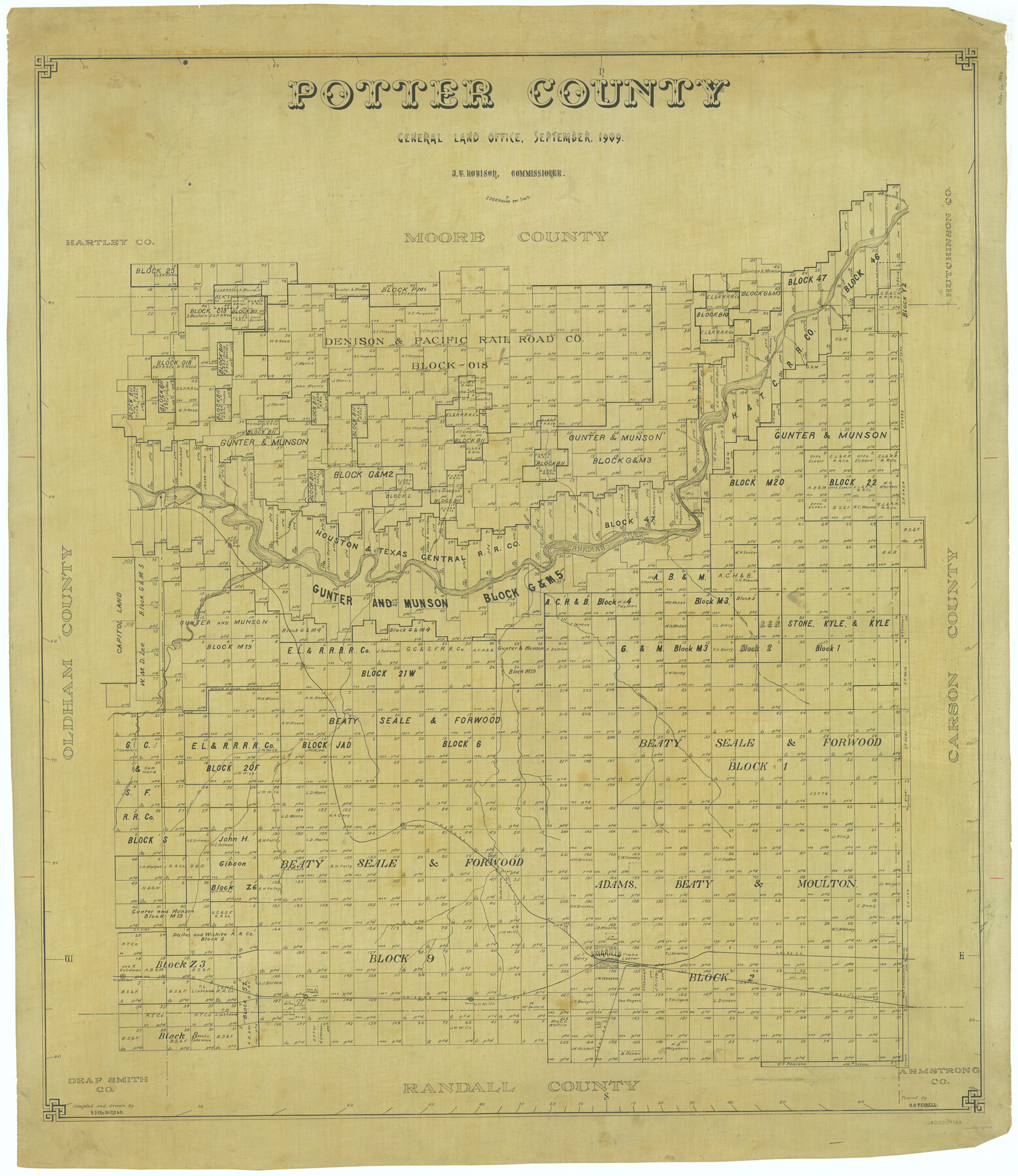
Potter County
-
Map/Doc
66983
-
Collection
General Map Collection
-
Object Dates
1909 (Creation Date)
-
People and Organizations
Texas General Land Office (Publisher)
J.T. Robison (GLO Commissioner)
H.F. McDonald (Draftsman)
H.F. McDonald (Compiler)
-
Counties
Potter
-
Subjects
County
-
Height x Width
47.3 x 41.0 inches
120.1 x 104.1 cm
-
Comments
Traced by O. O. Terrell.
Part of: General Map Collection
Brazoria County Rolled Sketch 40

Print $20.00
- Digital $50.00
Brazoria County Rolled Sketch 40
1954
Size 32.1 x 21.5 inches
Map/Doc 5175
Houston County Rolled Sketch 12

Print $20.00
- Digital $50.00
Houston County Rolled Sketch 12
Size 11.8 x 18.1 inches
Map/Doc 95396
Port Aransas-Corpus Christi Waterway, Texas, Avery Point Turning Basin to Vicinity of Tule Lake - Dredging

Print $20.00
- Digital $50.00
Port Aransas-Corpus Christi Waterway, Texas, Avery Point Turning Basin to Vicinity of Tule Lake - Dredging
1947
Size 28.4 x 41.4 inches
Map/Doc 60302
Nueces County Working Sketch 12

Print $20.00
- Digital $50.00
Nueces County Working Sketch 12
2011
Size 22.0 x 42.3 inches
Map/Doc 90047
Deaf Smith County Rolled Sketch 1

Print $20.00
- Digital $50.00
Deaf Smith County Rolled Sketch 1
1965
Size 24.8 x 25.9 inches
Map/Doc 5698
San Augustine County Sketch File 19

Print $23.00
San Augustine County Sketch File 19
Size 14.8 x 14.2 inches
Map/Doc 35678
Brewster County Working Sketch 19

Print $20.00
- Digital $50.00
Brewster County Working Sketch 19
1935
Size 15.7 x 13.0 inches
Map/Doc 67551
Colored Map of Texas Gulf Coast from Sabine River to the Rio Grande

Print $20.00
- Digital $50.00
Colored Map of Texas Gulf Coast from Sabine River to the Rio Grande
1950
Size 44.7 x 43.0 inches
Map/Doc 3014
Red River County Working Sketch 48

Print $20.00
- Digital $50.00
Red River County Working Sketch 48
1970
Size 28.6 x 30.2 inches
Map/Doc 72031
Ward County Working Sketch 4

Print $20.00
- Digital $50.00
Ward County Working Sketch 4
1943
Size 17.0 x 16.7 inches
Map/Doc 72310
Hudspeth County Working Sketch 12

Print $20.00
- Digital $50.00
Hudspeth County Working Sketch 12
1948
Size 18.2 x 38.6 inches
Map/Doc 66294
Crosby County Sketch File 11

Print $64.00
- Digital $50.00
Crosby County Sketch File 11
Size 13.8 x 8.9 inches
Map/Doc 20017
You may also like
Right of Way and Track Map, St. Louis, Brownsville & Mexico Railway operated by St. Louis Brownsville & Mexico Ry. Co., Jefferson Lake Oil Company

Print $40.00
- Digital $50.00
Right of Way and Track Map, St. Louis, Brownsville & Mexico Railway operated by St. Louis Brownsville & Mexico Ry. Co., Jefferson Lake Oil Company
1937
Size 25.3 x 57.1 inches
Map/Doc 64612
Denton County Working Sketch 15

Print $20.00
- Digital $50.00
Denton County Working Sketch 15
1971
Size 21.7 x 30.0 inches
Map/Doc 68620

Edwards County Working Sketch 51

Print $20.00
- Digital $50.00
Edwards County Working Sketch 51
1950
Size 21.8 x 22.7 inches
Map/Doc 68927
Hunt County Sketch File 39

Print $8.00
- Digital $50.00
Hunt County Sketch File 39
1922
Size 14.3 x 8.8 inches
Map/Doc 27159
University Lands Hudspeth County, Texas, Blocks A to N

Print $40.00
- Digital $50.00
University Lands Hudspeth County, Texas, Blocks A to N
1935
Size 38.6 x 55.4 inches
Map/Doc 2447
Zapata County Sketch File 10

Print $40.00
- Digital $50.00
Zapata County Sketch File 10
1917
Size 51.0 x 32.6 inches
Map/Doc 10440
Bowie County Sketch File 6

Print $10.00
- Digital $50.00
Bowie County Sketch File 6
1927
Size 8.5 x 4.0 inches
Map/Doc 14839
[Sketch of a portion of Hutchinson County, Texas]
![413, [Sketch of a portion of Hutchinson County, Texas], Maddox Collection](https://historictexasmaps.com/wmedia_w700/maps/0413.tif.jpg)
Print $20.00
- Digital $50.00
[Sketch of a portion of Hutchinson County, Texas]
1889
Size 14.9 x 17.3 inches
Map/Doc 413
Motley County

Print $20.00
- Digital $50.00
Motley County
1914
Size 47.7 x 37.4 inches
Map/Doc 10797
Brooks County Rolled Sketch 19

Print $84.00
- Digital $50.00
Brooks County Rolled Sketch 19
Size 43.3 x 59.2 inches
Map/Doc 8533
Red River County Working Sketch 62

Print $20.00
- Digital $50.00
Red River County Working Sketch 62
1973
Size 27.1 x 40.0 inches
Map/Doc 72045