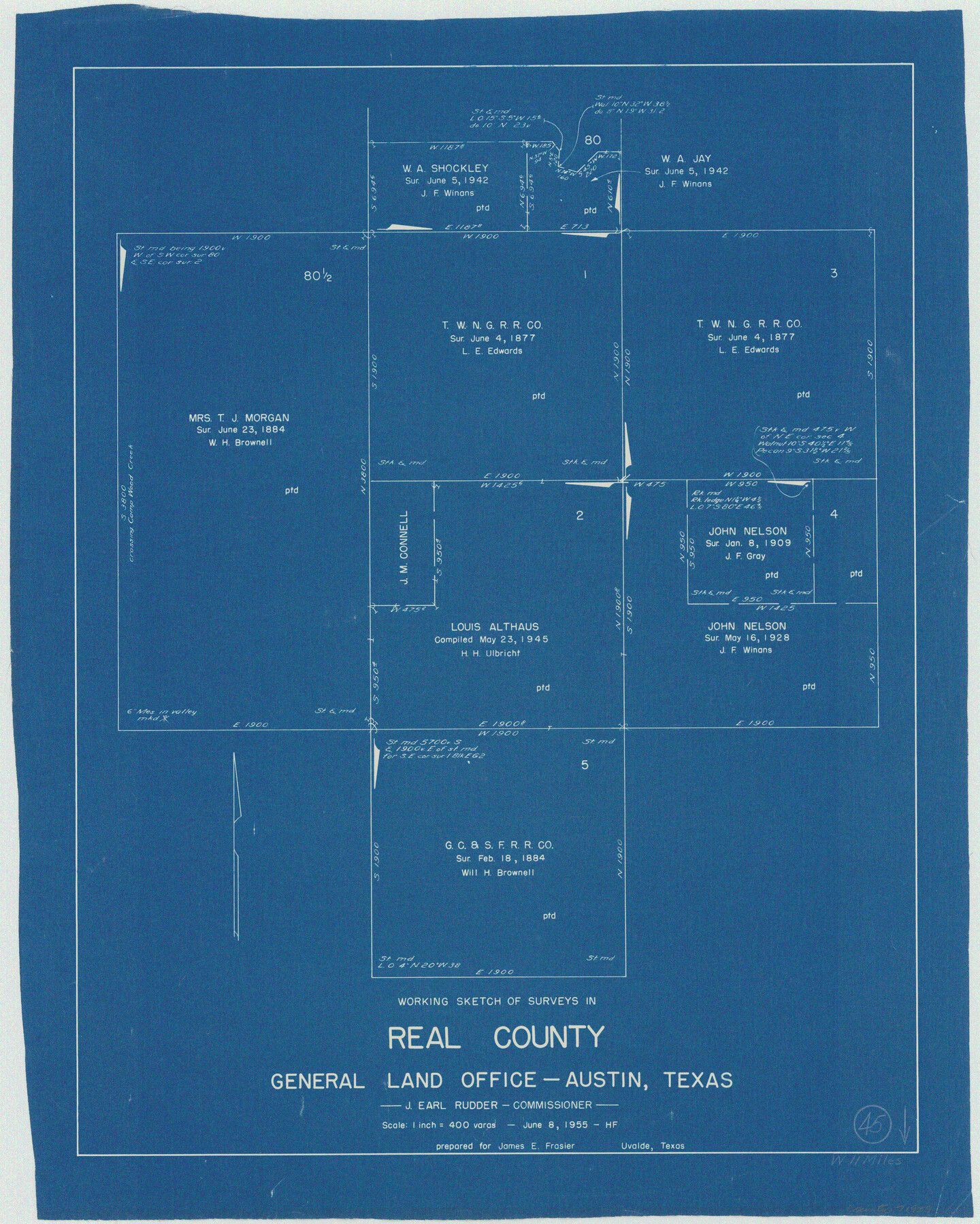
Real County Working Sketch 45
-
Map/Doc
71937
-
Collection
General Map Collection
-
Object Dates
6/8/1955 (Creation Date)
-
People and Organizations
Herman Forbes (Draftsman)
-
Counties
Real
-
Subjects
Surveying Working Sketch
-
Height x Width
23.1 x 18.5 inches
58.7 x 47.0 cm
-
Scale
1" = 400 varas
Part of: General Map Collection
Map of Bexar County

Print $20.00
- Digital $50.00
Map of Bexar County
1896
Size 46.2 x 39.9 inches
Map/Doc 4766
Corpus Christi Bay, Texas

Print $40.00
- Digital $50.00
Corpus Christi Bay, Texas
1867
Size 33.9 x 54.8 inches
Map/Doc 73470
Loving County Rolled Sketch 10

Print $20.00
- Digital $50.00
Loving County Rolled Sketch 10
1990
Size 32.0 x 43.6 inches
Map/Doc 9468
Wheeler County Working Sketch 19

Print $20.00
- Digital $50.00
Wheeler County Working Sketch 19
1986
Size 33.5 x 31.8 inches
Map/Doc 72508
Glasscock County Rolled Sketch 15

Print $20.00
- Digital $50.00
Glasscock County Rolled Sketch 15
1964
Size 36.5 x 35.8 inches
Map/Doc 9059
Jeff Davis County Rolled Sketch 37

Print $20.00
- Digital $50.00
Jeff Davis County Rolled Sketch 37
1992
Size 29.3 x 35.5 inches
Map/Doc 6380
Wilbarger County Boundary File 1c

Print $6.00
- Digital $50.00
Wilbarger County Boundary File 1c
Size 12.2 x 9.6 inches
Map/Doc 59954

Tyler County Sketch File 4

Print $4.00
- Digital $50.00
Tyler County Sketch File 4
1857
Size 13.9 x 8.4 inches
Map/Doc 38628
Shelby County Sketch File 22

Print $6.00
- Digital $50.00
Shelby County Sketch File 22
Size 15.4 x 10.2 inches
Map/Doc 36643
Stieler Map of 1879

Print $4.00
- Digital $50.00
Stieler Map of 1879
1879
Size 28.9 x 23.1 inches
Map/Doc 76054
Wichita County Sketch File 13

Print $22.00
- Digital $50.00
Wichita County Sketch File 13
Size 7.9 x 10.6 inches
Map/Doc 40082
You may also like
Bee County Sketch File Y

Print $4.00
- Digital $50.00
Bee County Sketch File Y
Size 8.8 x 5.4 inches
Map/Doc 14255

Hudspeth County Sketch File 9

Print $8.00
- Digital $50.00
Hudspeth County Sketch File 9
1900
Size 11.3 x 8.8 inches
Map/Doc 26895
Flight Mission No. DQO-3K, Frame 21, Galveston County

Print $20.00
- Digital $50.00
Flight Mission No. DQO-3K, Frame 21, Galveston County
1952
Size 18.9 x 22.5 inches
Map/Doc 85062
Val Verde County Sketch File XXX5

Print $40.00
- Digital $50.00
Val Verde County Sketch File XXX5
Size 13.2 x 13.4 inches
Map/Doc 39100

[Galveston, Harrisburg & San Antonio Railroad from Cuero to Stockdale]
![64202, [Galveston, Harrisburg & San Antonio Railroad from Cuero to Stockdale], General Map Collection](https://historictexasmaps.com/wmedia_w700/maps/64202.tif.jpg)
Print $20.00
- Digital $50.00
[Galveston, Harrisburg & San Antonio Railroad from Cuero to Stockdale]
1907
Size 13.3 x 33.1 inches
Map/Doc 64202
Bexar County Rolled Sketch 16

Print $20.00
- Digital $50.00
Bexar County Rolled Sketch 16
1847
Size 21.1 x 14.8 inches
Map/Doc 5141
Treaty to Resolve Pending Boundary Differences and Maintain the Rio Grande and Colorado River as the International Boundary Between the United States of American and Mexico

Print $4.00
- Digital $50.00
Treaty to Resolve Pending Boundary Differences and Maintain the Rio Grande and Colorado River as the International Boundary Between the United States of American and Mexico
1970
Size 12.1 x 19.0 inches
Map/Doc 83099
Grimes Estate Lands, Cochran County, Texas

Print $20.00
- Digital $50.00
Grimes Estate Lands, Cochran County, Texas
Size 25.6 x 21.6 inches
Map/Doc 92520
Flight Mission No. CRE-1R, Frame 133, Jackson County

Print $20.00
- Digital $50.00
Flight Mission No. CRE-1R, Frame 133, Jackson County
1956
Size 16.2 x 16.2 inches
Map/Doc 85341
Flight Mission No. CUG-1P, Frame 160, Kleberg County

Print $20.00
- Digital $50.00
Flight Mission No. CUG-1P, Frame 160, Kleberg County
1956
Size 18.5 x 22.4 inches
Map/Doc 86167