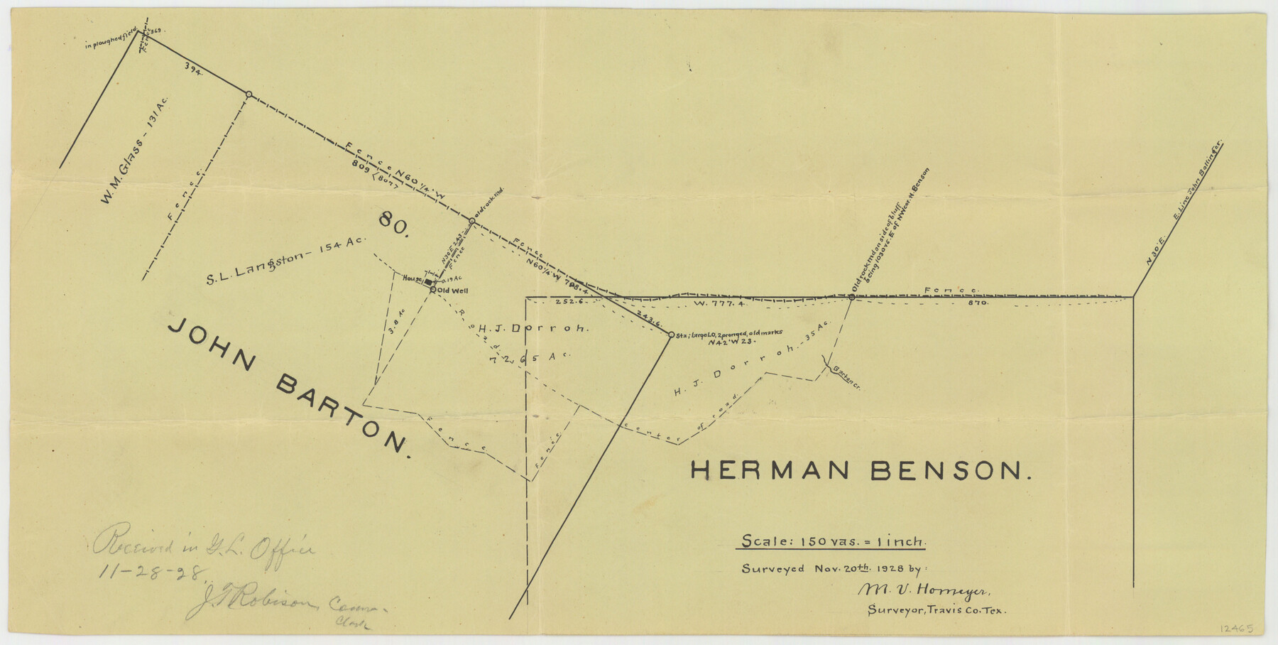
Travis County Sketch File 41
[Sketch and field notes of connecting line between the John Barton survey 80 and Herman Benson survey 139]
-
Map/Doc
12465
-
Collection
General Map Collection
-
Object Dates
11/20/1928 (Creation Date)
11/28/1928 (File Date)
-
People and Organizations
M.V. Homeyer (Surveyor/Engineer)
-
Counties
Travis
-
Subjects
Surveying Sketch File
-
Height x Width
11.7 x 30.2 inches
29.7 x 76.7 cm
-
Medium
blueprint/diazo
-
Scale
1" = 150 varas
-
Features
Barton Creek
Part of: General Map Collection
Jefferson County NRC Article 33.136 Sketch 2

Print $20.00
- Digital $50.00
Jefferson County NRC Article 33.136 Sketch 2
2002
Size 24.3 x 35.9 inches
Map/Doc 77048

Map of Galveston Harbor and City

Print $40.00
- Digital $50.00
Map of Galveston Harbor and City
1850
Size 31.0 x 52.0 inches
Map/Doc 69856
Flight Mission No. BRE-1P, Frame 150, Nueces County

Print $20.00
- Digital $50.00
Flight Mission No. BRE-1P, Frame 150, Nueces County
1956
Size 18.6 x 22.1 inches
Map/Doc 86710
[Surveys in the Jefferson District]
![3177, [Surveys in the Jefferson District], General Map Collection](https://historictexasmaps.com/wmedia_w700/maps/3177.tif.jpg)
Print $2.00
- Digital $50.00
[Surveys in the Jefferson District]
1841
Size 9.8 x 8.0 inches
Map/Doc 3177
Jim Hogg County Working Sketch 2

Print $20.00
- Digital $50.00
Jim Hogg County Working Sketch 2
1933
Size 41.2 x 29.3 inches
Map/Doc 66588
Erath County Working Sketch 43

Print $20.00
- Digital $50.00
Erath County Working Sketch 43
1981
Size 19.6 x 15.7 inches
Map/Doc 69124
Hale County Rolled Sketch 5

Print $20.00
- Digital $50.00
Hale County Rolled Sketch 5
1893
Size 29.0 x 22.2 inches
Map/Doc 9094
Harris County NRC Article 33.136 Sketch 5

Print $20.00
- Digital $50.00
Harris County NRC Article 33.136 Sketch 5
2002
Size 22.2 x 34.1 inches
Map/Doc 77047
Young County Working Sketch 20

Print $20.00
- Digital $50.00
Young County Working Sketch 20
1961
Size 25.5 x 23.2 inches
Map/Doc 62043
Wharton County Working Sketch 16

Print $20.00
- Digital $50.00
Wharton County Working Sketch 16
1952
Size 23.8 x 26.8 inches
Map/Doc 72480
Culberson County Working Sketch 88

Print $20.00
- Digital $50.00
Culberson County Working Sketch 88
1983
Size 32.8 x 37.1 inches
Map/Doc 68542
You may also like
Flight Mission No. CGI-2N, Frame 154, Cameron County

Print $20.00
- Digital $50.00
Flight Mission No. CGI-2N, Frame 154, Cameron County
1954
Size 18.6 x 19.0 inches
Map/Doc 84536
Montgomery Co.

Print $40.00
- Digital $50.00
Montgomery Co.
1943
Size 45.2 x 54.8 inches
Map/Doc 95594
Nolan County Sketch File A

Print $20.00
- Digital $50.00
Nolan County Sketch File A
Size 22.4 x 19.9 inches
Map/Doc 42170
Gillespie County Boundary File 4

Print $56.00
- Digital $50.00
Gillespie County Boundary File 4
Size 13.6 x 9.0 inches
Map/Doc 53754
Wise County Working Sketch 11

Print $20.00
- Digital $50.00
Wise County Working Sketch 11
1958
Size 18.5 x 30.6 inches
Map/Doc 72625
Matagorda County NRC Article 33.136 Sketch 1

Print $21.00
- Digital $50.00
Matagorda County NRC Article 33.136 Sketch 1
2004
Size 17.6 x 23.1 inches
Map/Doc 82920
Terry County Working Sketch Graphic Index

Print $20.00
- Digital $50.00
Terry County Working Sketch Graphic Index
1970
Size 41.2 x 33.8 inches
Map/Doc 76712
Map and Field Notes of D. & N. T. RR. Through E. L. Ellwood's Pasture

Print $20.00
- Digital $50.00
Map and Field Notes of D. & N. T. RR. Through E. L. Ellwood's Pasture
1912
Size 39.5 x 12.1 inches
Map/Doc 91003
Asher & Adams' Geological Map - United States and Territories

Print $20.00
- Digital $50.00
Asher & Adams' Geological Map - United States and Territories
1874
Size 17.9 x 24.9 inches
Map/Doc 95175
Dimmit County Sketch File 9

Print $6.00
- Digital $50.00
Dimmit County Sketch File 9
Size 8.9 x 11.2 inches
Map/Doc 21070
Kaufman County Boundary File 6b

Print $6.00
- Digital $50.00
Kaufman County Boundary File 6b
Size 14.2 x 8.5 inches
Map/Doc 55966
Flight Mission No. DQN-1K, Frame 68, Calhoun County

Print $20.00
- Digital $50.00
Flight Mission No. DQN-1K, Frame 68, Calhoun County
1953
Size 18.6 x 22.2 inches
Map/Doc 84155