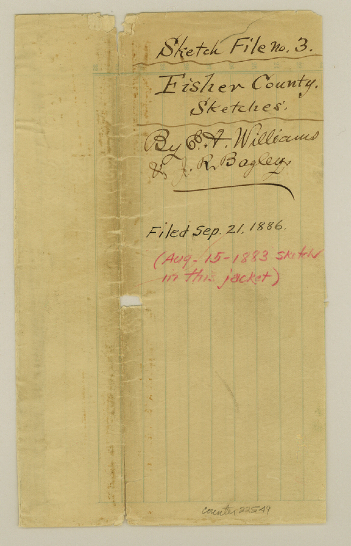
Fisher County Sketch File 3
Part 2
-
Map/Doc
22549
-
Collection
General Map Collection
-
Object Dates
1886/9/21 (File Date)
1886/9/5 (Creation Date)
-
People and Organizations
E.A. Williams (Surveyor/Engineer)
McDonald (Surveyor/Engineer)
J.P. Bagley (Surveyor/Engineer)
-
Counties
Fisher
-
Subjects
Surveying Sketch File
-
Height x Width
8.9 x 5.8 inches
22.6 x 14.7 cm
-
Medium
paper, manuscript
-
Scale
1:2000
-
Features
Cottonwood Creek
Clear Fork of the Brazos River
Alkali Creek
Salt Creek
China Creek
Plum Creek
Part of: General Map Collection
[Sketch for Mineral Application 14125 - Neches River, R. B. Moore]
![65667, [Sketch for Mineral Application 14125 - Neches River, R. B. Moore], General Map Collection](https://historictexasmaps.com/wmedia_w700/maps/65667.tif.jpg)
Print $40.00
- Digital $50.00
[Sketch for Mineral Application 14125 - Neches River, R. B. Moore]
1928
Size 26.1 x 50.0 inches
Map/Doc 65667
Travis County Sketch File 30

Print $6.00
- Digital $50.00
Travis County Sketch File 30
1884
Size 17.0 x 11.0 inches
Map/Doc 38343
Flight Mission No. BRA-6M, Frame 145, Jefferson County

Print $20.00
- Digital $50.00
Flight Mission No. BRA-6M, Frame 145, Jefferson County
1953
Size 18.4 x 22.4 inches
Map/Doc 85446
Coleman County Sketch File 4

Print $2.00
- Digital $50.00
Coleman County Sketch File 4
1855
Size 8.2 x 8.8 inches
Map/Doc 18672
Current Miscellaneous File 59

Print $16.00
- Digital $50.00
Current Miscellaneous File 59
1836
Size 11.4 x 8.9 inches
Map/Doc 74056
Travis County Sketch File 8

Print $4.00
- Digital $50.00
Travis County Sketch File 8
Size 10.2 x 8.1 inches
Map/Doc 38288
San Patricio County Sketch File 40

Print $4.00
- Digital $50.00
San Patricio County Sketch File 40
1842
Size 10.5 x 8.2 inches
Map/Doc 36236
Austin County Working Sketch 9

Print $20.00
- Digital $50.00
Austin County Working Sketch 9
1996
Size 34.4 x 32.0 inches
Map/Doc 67250
McMullen County Sketch File 2

Print $22.00
- Digital $50.00
McMullen County Sketch File 2
1849
Size 8.3 x 12.4 inches
Map/Doc 31337
Hardeman County Sketch File 14a

Print $20.00
- Digital $50.00
Hardeman County Sketch File 14a
Size 24.4 x 29.0 inches
Map/Doc 11626
Gillespie County Sketch File 3b

Print $4.00
- Digital $50.00
Gillespie County Sketch File 3b
1860
Size 8.2 x 12.6 inches
Map/Doc 24133
Map of City of Fort Worth, Texas

Print $20.00
- Digital $50.00
Map of City of Fort Worth, Texas
1934
Size 32.9 x 39.2 inches
Map/Doc 4839
You may also like
Tarrant County Sketch File 16

Print $4.00
- Digital $50.00
Tarrant County Sketch File 16
1861
Size 8.2 x 6.4 inches
Map/Doc 37710
[Texas Boundary Line]
![92070, [Texas Boundary Line], Twichell Survey Records](https://historictexasmaps.com/wmedia_w700/maps/92070-1.tif.jpg)
Print $20.00
- Digital $50.00
[Texas Boundary Line]
Size 21.5 x 12.0 inches
Map/Doc 92070
Sketch Showing Block 33, Township 5 North, T. & P. RR. Surveys

Print $20.00
- Digital $50.00
Sketch Showing Block 33, Township 5 North, T. & P. RR. Surveys
1921
Size 23.2 x 22.7 inches
Map/Doc 90635
Val Verde County Sketch File A2

Print $10.00
- Digital $50.00
Val Verde County Sketch File A2
1916
Size 14.5 x 9.1 inches
Map/Doc 39041
[1/4 of a WWI French map of Attigny used by the 142nd Infantry for planning purposes for the Battle of Forest Ferme (farm)]
![96642, [1/4 of a WWI French map of Attigny used by the 142nd Infantry for planning purposes for the Battle of Forest Ferme (farm)], Non-GLO Digital Images](https://historictexasmaps.com/wmedia_w700/maps/96642.tif.jpg)
Print $20.00
[1/4 of a WWI French map of Attigny used by the 142nd Infantry for planning purposes for the Battle of Forest Ferme (farm)]
1918
Size 21.1 x 17.7 inches
Map/Doc 96642
Goliad County Working Sketch 18

Print $20.00
- Digital $50.00
Goliad County Working Sketch 18
1949
Size 31.2 x 39.4 inches
Map/Doc 63208
Red River County

Print $20.00
- Digital $50.00
Red River County
1934
Size 47.0 x 40.2 inches
Map/Doc 95623
Eastland County Working Sketch 6

Print $20.00
- Digital $50.00
Eastland County Working Sketch 6
1918
Size 17.2 x 11.4 inches
Map/Doc 68787
Van Zandt County Sketch File 43

Print $4.00
- Digital $50.00
Van Zandt County Sketch File 43
1874
Size 12.7 x 8.1 inches
Map/Doc 39497
Presidio County Working Sketch 26

Print $20.00
- Digital $50.00
Presidio County Working Sketch 26
1945
Size 41.9 x 24.3 inches
Map/Doc 71702
Dimmit County Working Sketch 19

Print $20.00
- Digital $50.00
Dimmit County Working Sketch 19
1948
Size 27.4 x 23.3 inches
Map/Doc 68680
Trinity County Working Sketch 8

Print $3.00
- Digital $50.00
Trinity County Working Sketch 8
1941
Size 14.7 x 10.8 inches
Map/Doc 69457