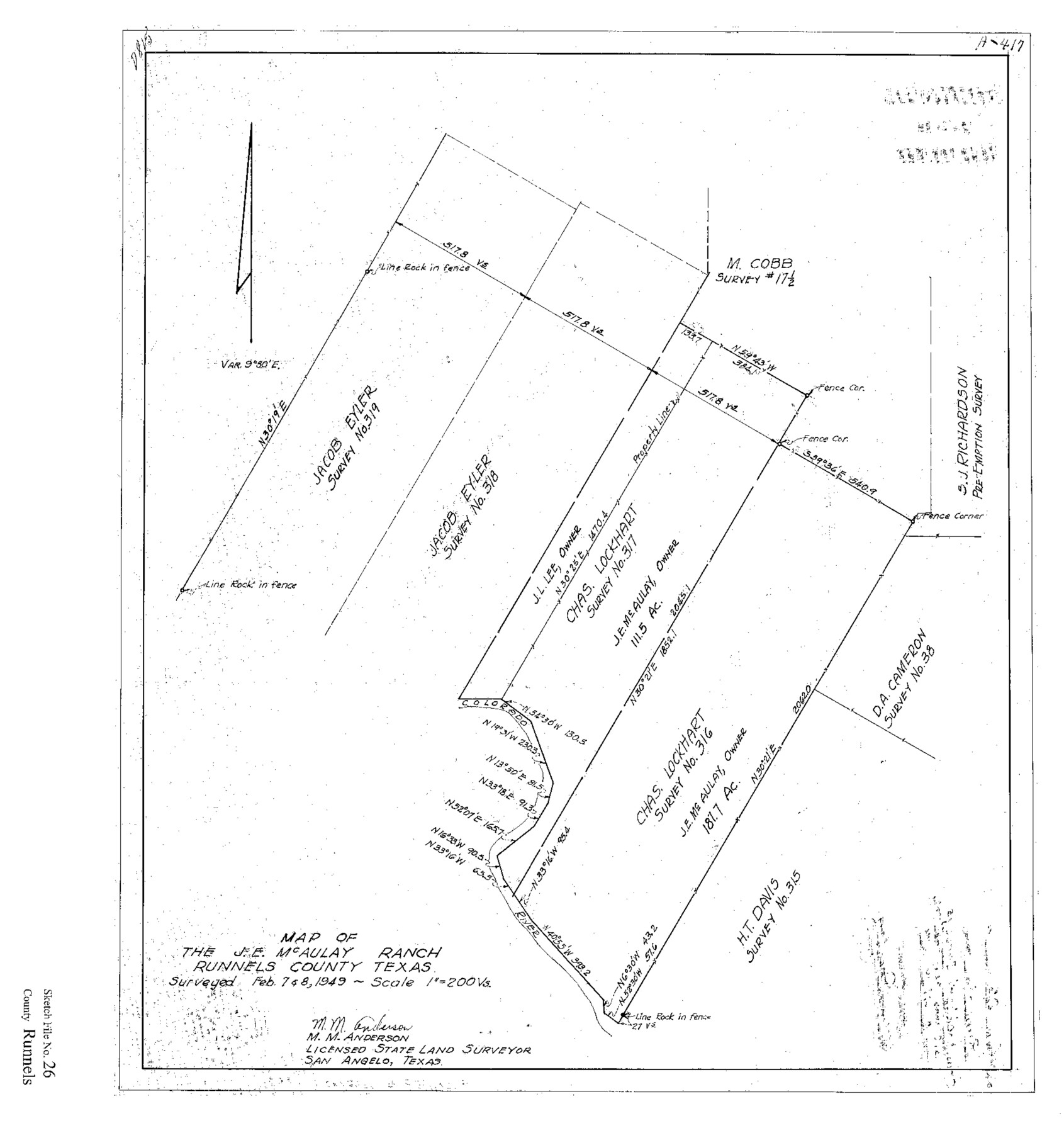
Runnels County Sketch File 26
Map of the J.E. McAulay Ranch, Runnels County, Texas
-
Map/Doc
12260
-
Collection
General Map Collection
-
Object Dates
1949 (Creation Date)
4/19/1949 (File Date)
2/7 and 2/8/1949 (Survey Date)
-
People and Organizations
M.M. Anderson (Surveyor/Engineer)
-
Counties
Runnels
-
Subjects
Surveying Sketch File
-
Height x Width
20.0 x 18.8 inches
50.8 x 47.8 cm
-
Medium
paper, print
-
Scale
1" = 200 varas
-
Features
Colorado River
J.E. McAulay Ranch
Part of: General Map Collection
Runnels County Rolled Sketch B

Print $20.00
- Digital $50.00
Runnels County Rolled Sketch B
1891
Size 17.4 x 19.3 inches
Map/Doc 7540
Terrell County

Print $20.00
- Digital $50.00
Terrell County
1931
Size 40.0 x 33.4 inches
Map/Doc 77433
Shelby County Rolled Sketch 3

Print $40.00
- Digital $50.00
Shelby County Rolled Sketch 3
Size 54.2 x 37.0 inches
Map/Doc 9919
Dimmit County Working Sketch 25

Print $20.00
- Digital $50.00
Dimmit County Working Sketch 25
1955
Size 24.9 x 18.3 inches
Map/Doc 68686
El Paso County Rolled Sketch Z60
Print $20.00
- Digital $50.00
El Paso County Rolled Sketch Z60
1915
Size 37.3 x 47.7 inches
Map/Doc 8873
[St. Louis & Southwestern]
![64277, [St. Louis & Southwestern], General Map Collection](https://historictexasmaps.com/wmedia_w700/maps/64277.tif.jpg)
Print $20.00
- Digital $50.00
[St. Louis & Southwestern]
Size 20.6 x 28.7 inches
Map/Doc 64277
Reagan County Working Sketch 47

Print $20.00
- Digital $50.00
Reagan County Working Sketch 47
1987
Size 23.9 x 43.8 inches
Map/Doc 71890
Crane County Working Sketch 22

Print $20.00
- Digital $50.00
Crane County Working Sketch 22
1961
Size 44.7 x 43.9 inches
Map/Doc 68299
Foard County Rolled Sketch 15A

Print $20.00
- Digital $50.00
Foard County Rolled Sketch 15A
1889
Size 37.3 x 39.8 inches
Map/Doc 75936
Pecos County Boundary File 69a

Print $40.00
- Digital $50.00
Pecos County Boundary File 69a
Size 8.4 x 9.7 inches
Map/Doc 57901
San Patricio County Rolled Sketch BB

Print $40.00
- Digital $50.00
San Patricio County Rolled Sketch BB
1936
Size 25.0 x 49.0 inches
Map/Doc 9889
Kenedy County Rolled Sketch 4A

Print $40.00
- Digital $50.00
Kenedy County Rolled Sketch 4A
1904
Size 40.0 x 56.5 inches
Map/Doc 9332
You may also like
Howard County Rolled Sketch 12

Print $20.00
- Digital $50.00
Howard County Rolled Sketch 12
Size 25.8 x 16.5 inches
Map/Doc 6243
Jefferson County Working Sketch 31

Print $20.00
- Digital $50.00
Jefferson County Working Sketch 31
1982
Size 21.3 x 27.6 inches
Map/Doc 66575
Sabine Bank to East Bay including Heald Bank

Print $20.00
- Digital $50.00
Sabine Bank to East Bay including Heald Bank
1925
Size 44.2 x 34.8 inches
Map/Doc 69844
Flight Mission No. DIX-6P, Frame 112, Aransas County

Print $20.00
- Digital $50.00
Flight Mission No. DIX-6P, Frame 112, Aransas County
1956
Size 18.9 x 22.7 inches
Map/Doc 83818
Bosque County Working Sketch 12

Print $20.00
- Digital $50.00
Bosque County Working Sketch 12
1957
Size 18.3 x 21.8 inches
Map/Doc 67445
Travis County Sketch File 4

Print $9.00
- Digital $50.00
Travis County Sketch File 4
1853
Size 13.1 x 8.2 inches
Map/Doc 38275
Map of Kendall County

Print $20.00
- Digital $50.00
Map of Kendall County
1899
Size 37.9 x 33.9 inches
Map/Doc 4678

Val Verde County Rolled Sketch 66

Print $40.00
- Digital $50.00
Val Verde County Rolled Sketch 66
1957
Size 30.7 x 55.0 inches
Map/Doc 10084
Polk County Sketch File 41

Print $10.00
- Digital $50.00
Polk County Sketch File 41
Size 12.7 x 8.2 inches
Map/Doc 34292
McMullen County Rolled Sketch 13

Print $20.00
- Digital $50.00
McMullen County Rolled Sketch 13
1943
Size 45.8 x 29.4 inches
Map/Doc 6730
Trace of a copy of the map captured at the battle of Resaca de la Palma

Print $20.00
- Digital $50.00
Trace of a copy of the map captured at the battle of Resaca de la Palma
Size 18.4 x 27.4 inches
Map/Doc 73055