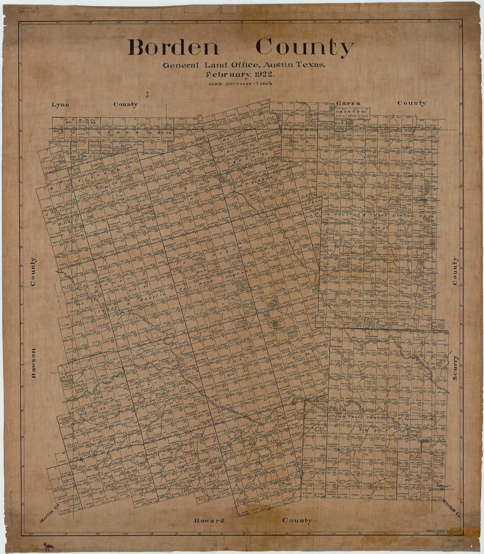
Borden County
RM-1-17
-
Map/Doc
1782
-
Collection
General Map Collection
-
Object Dates
2/9/1922 (Creation Date)
-
People and Organizations
John D. Hedick (Draftsman)
-
Counties
Borden
-
Subjects
County
-
Height x Width
44.2 x 38.5 inches
112.3 x 97.8 cm
-
Scale
1" = 2000 varas
Part of: General Map Collection
Gregg County Working Sketch 3

Print $20.00
- Digital $50.00
Gregg County Working Sketch 3
1931
Size 18.6 x 14.2 inches
Map/Doc 63269
Burnet County Sketch File 2

Print $4.00
- Digital $50.00
Burnet County Sketch File 2
Size 8.1 x 6.1 inches
Map/Doc 16672
Kimble County Sketch File 1

Print $4.00
- Digital $50.00
Kimble County Sketch File 1
1854
Size 7.2 x 10.0 inches
Map/Doc 28907
Potter County

Print $20.00
- Digital $50.00
Potter County
1960
Size 43.5 x 35.6 inches
Map/Doc 95615
Lynn County Working Sketch 4

Print $20.00
- Digital $50.00
Lynn County Working Sketch 4
1965
Size 33.5 x 33.8 inches
Map/Doc 70674
Flight Mission No. BRA-16M, Frame 160, Jefferson County

Print $20.00
- Digital $50.00
Flight Mission No. BRA-16M, Frame 160, Jefferson County
1953
Size 18.7 x 22.3 inches
Map/Doc 85758

Panola County Working Sketch 25

Print $20.00
- Digital $50.00
Panola County Working Sketch 25
1957
Map/Doc 71434
Culberson County Working Sketch 15

Print $20.00
- Digital $50.00
Culberson County Working Sketch 15
1923
Size 19.9 x 21.5 inches
Map/Doc 68467
Texas Official Travel Map

Digital $50.00
Texas Official Travel Map
Size 33.4 x 36.4 inches
Map/Doc 94424
Crockett County Working Sketch 8

Print $20.00
- Digital $50.00
Crockett County Working Sketch 8
1903
Size 15.2 x 30.3 inches
Map/Doc 68341
Flight Mission No. CUG-1P, Frame 19, Kleberg County

Print $20.00
- Digital $50.00
Flight Mission No. CUG-1P, Frame 19, Kleberg County
1956
Size 18.6 x 22.2 inches
Map/Doc 86109
You may also like

Chambers County Rolled Sketch 19

Print $20.00
- Digital $50.00
Chambers County Rolled Sketch 19
Size 39.8 x 44.4 inches
Map/Doc 8588
Matagorda County Sketch File 2

Print $6.00
- Digital $50.00
Matagorda County Sketch File 2
1866
Size 15.9 x 10.8 inches
Map/Doc 30730
Ashburn's 1951 Austin City Map

Ashburn's 1951 Austin City Map
1951
Size 22.5 x 17.4 inches
Map/Doc 97142
The Republic County of Jackson. January 29, 1842

Print $20.00
The Republic County of Jackson. January 29, 1842
2020
Size 15.6 x 21.8 inches
Map/Doc 96189
Ector County Working Sketch 5

Print $20.00
- Digital $50.00
Ector County Working Sketch 5
1941
Size 44.7 x 27.1 inches
Map/Doc 68848
Presidio County Rolled Sketch 128

Print $20.00
- Digital $50.00
Presidio County Rolled Sketch 128
1931
Size 26.9 x 38.0 inches
Map/Doc 7398

Sketch Showing Reed and Meeker Vacancy, Cochran County, Texas

Print $20.00
- Digital $50.00
Sketch Showing Reed and Meeker Vacancy, Cochran County, Texas
Size 28.9 x 20.3 inches
Map/Doc 92514
Fannin County Rolled Sketch 18F

Print $2.00
- Digital $50.00
Fannin County Rolled Sketch 18F
Size 8.9 x 8.2 inches
Map/Doc 5873
Wilbarger County Sketch File 10

Print $20.00
- Digital $50.00
Wilbarger County Sketch File 10
1894
Size 33.9 x 38.7 inches
Map/Doc 10434
Zavala County Sketch File 17

Print $64.00
- Digital $50.00
Zavala County Sketch File 17
1900
Size 9.1 x 10.1 inches
Map/Doc 41324