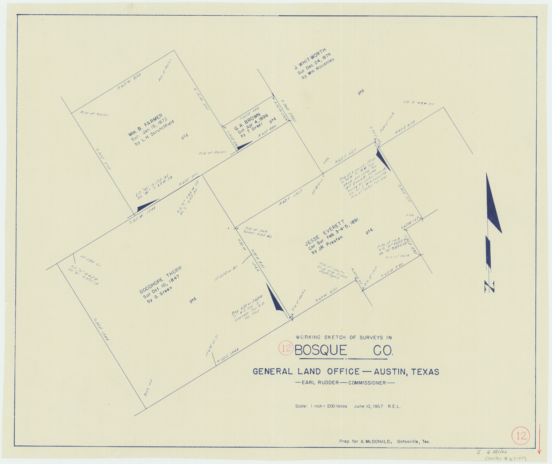
Bosque County Working Sketch 12
- 
                          Map/Doc
67445
 - 
                            Collection
General Map Collection
 - 
                            Object Dates
6/10/1957 (Creation Date)
 - 
                            People and Organizations
J. Earl Rudder (GLO Commissioner)
 - 
                            Counties
Bosque
 - 
                            Subjects
Surveying Working Sketch
 - 
                            Height x Width
18.3 x 21.8 inches
46.5 x 55.4 cm
 - 
                            Scale
1" = 200 varas
 - 
                            Comments
Surveys located about six miles South of Meridian, Texas.
 
Part of: General Map Collection
            Zavala County Boundary File 1


                                            Print $48.00                    
                                             -                         Digital $50.00                                    
                Zavala County Boundary File 1
Size 12.8 x 8.3 inches
                                Map/Doc 60233
            
            Current Miscellaneous File 31


                                            Print $8.00                    
                                             -                         Digital $50.00                                    
                Current Miscellaneous File 31
1916
Size 11.2 x 8.7 inches
                                Map/Doc 73929
            
            Angelina County Working Sketch 56


                                            Print $20.00                    
                                             -                         Digital $50.00                                    
                Angelina County Working Sketch 56
1993
Size 38.0 x 36.0 inches
                                Map/Doc 67140
            
            Hutchinson County Sketch File 28


                                            Print $6.00                    
                                             -                         Digital $50.00                                    
                Hutchinson County Sketch File 28
1926
Size 11.3 x 8.8 inches
                                Map/Doc 27261
            
            Hemphill County Working Sketch 27


                                            Print $40.00                    
                                             -                         Digital $50.00                                    
                Hemphill County Working Sketch 27
1974
Size 50.7 x 43.5 inches
                                Map/Doc 66122
            
            [Sketch for Mineral Application 26649-26650 - Sabine River, Harry A. Wolan]


                                            Print $40.00                    
                                             -                         Digital $50.00                                    
                [Sketch for Mineral Application 26649-26650 - Sabine River, Harry A. Wolan]
Size 72.0 x 36.9 inches
                                Map/Doc 65566
            
            Karte des Staates Texas (aufgenommen in die Union 1846) nach der neuesten Eintheilung


                                            Print $20.00                    
                                             -                         Digital $50.00                                    
                Karte des Staates Texas (aufgenommen in die Union 1846) nach der neuesten Eintheilung
1849
Size 13.6 x 16.6 inches
                                Map/Doc 90066
            
            Presidio County Working Sketch 131


                                            Print $40.00                    
                                             -                         Digital $50.00                                    
                Presidio County Working Sketch 131
1989
Size 43.5 x 50.4 inches
                                Map/Doc 71809
            
            Palo Pinto County


                                            Print $40.00                    
                                             -                         Digital $50.00                                    
                Palo Pinto County
1941
Size 49.4 x 40.4 inches
                                Map/Doc 95606
            
            Bailey County Sketch File 21


                                            Print $14.00                    
                                             -                         Digital $50.00                                    
                Bailey County Sketch File 21
Size 11.3 x 8.8 inches
                                Map/Doc 13990
            
            Brazos River, Brazos River Sheet 5


                                            Print $4.00                    
                                             -                         Digital $50.00                                    
                Brazos River, Brazos River Sheet 5
1926
Size 29.4 x 22.5 inches
                                Map/Doc 65298
            
            Edwards County Sketch File 38


                                            Print $22.00                    
                                             -                         Digital $50.00                                    
                Edwards County Sketch File 38
1937
Size 11.2 x 8.6 inches
                                Map/Doc 21773
            You may also like
            Crane County Working Sketch 8


                                            Print $20.00                    
                                             -                         Digital $50.00                                    
                Crane County Working Sketch 8
1929
Size 33.2 x 28.4 inches
                                Map/Doc 68285
            
            [Portions of Blocks T1, B, and T]


                                            Print $2.00                    
                                             -                         Digital $50.00                                    
                [Portions of Blocks T1, B, and T]
1910
Size 13.8 x 4.3 inches
                                Map/Doc 90950
            
            Intracoastal Waterway, Houma, LA to Corpus Christi, TX


                                            Print $20.00                    
                                             -                         Digital $50.00                                    
                Intracoastal Waterway, Houma, LA to Corpus Christi, TX
Size 26.6 x 20.8 inches
                                Map/Doc 61907
            
            Lavaca County Working Sketch 5


                                            Print $20.00                    
                                             -                         Digital $50.00                                    
                Lavaca County Working Sketch 5
1940
Size 21.3 x 35.2 inches
                                Map/Doc 70358
            
            Montague County Sketch File 8


                                            Print $22.00                    
                                             -                         Digital $50.00                                    
                Montague County Sketch File 8
Size 8.1 x 3.7 inches
                                Map/Doc 31722
            
            Throckmorton County


                                            Print $20.00                    
                                             -                         Digital $50.00                                    
                Throckmorton County
1943
Size 46.7 x 37.4 inches
                                Map/Doc 95653
            
            [Sketch showing Block M-20, Sections 9 through 46 and Block 22, Sections 1 through 12]


                                            Print $3.00                    
                                             -                         Digital $50.00                                    
                [Sketch showing Block M-20, Sections 9 through 46 and Block 22, Sections 1 through 12]
Size 10.9 x 13.9 inches
                                Map/Doc 91717
            
            Photostat of section of hydrographic surveys H-5399, H-4822, H-470


                                            Print $20.00                    
                                             -                         Digital $50.00                                    
                Photostat of section of hydrographic surveys H-5399, H-4822, H-470
1933
Size 25.9 x 18.3 inches
                                Map/Doc 61158
            
            Mapa de los Estados Unidos de Méjico, Segun lo organizado y definido por las varias actas del Congreso de dicha Republica: y construido por las mejores autoridades


                                            Print $20.00                    
                                    
                Mapa de los Estados Unidos de Méjico, Segun lo organizado y definido por las varias actas del Congreso de dicha Republica: y construido por las mejores autoridades
1828
Size 29.3 x 41.6 inches
                                Map/Doc 76217
            
            Stephens County Sketch File 5


                                            Print $6.00                    
                                             -                         Digital $50.00                                    
                Stephens County Sketch File 5
Size 10.0 x 13.3 inches
                                Map/Doc 37019
            
            Pecos County Sketch File 19


                                            Print $4.00                    
                                             -                         Digital $50.00                                    
                Pecos County Sketch File 19
Size 14.2 x 8.8 inches
                                Map/Doc 33668
            
            Map of the Houston & Great Northern Railroad


                                            Print $40.00                    
                                             -                         Digital $50.00                                    
                Map of the Houston & Great Northern Railroad
1871
Size 29.3 x 122.1 inches
                                Map/Doc 64551