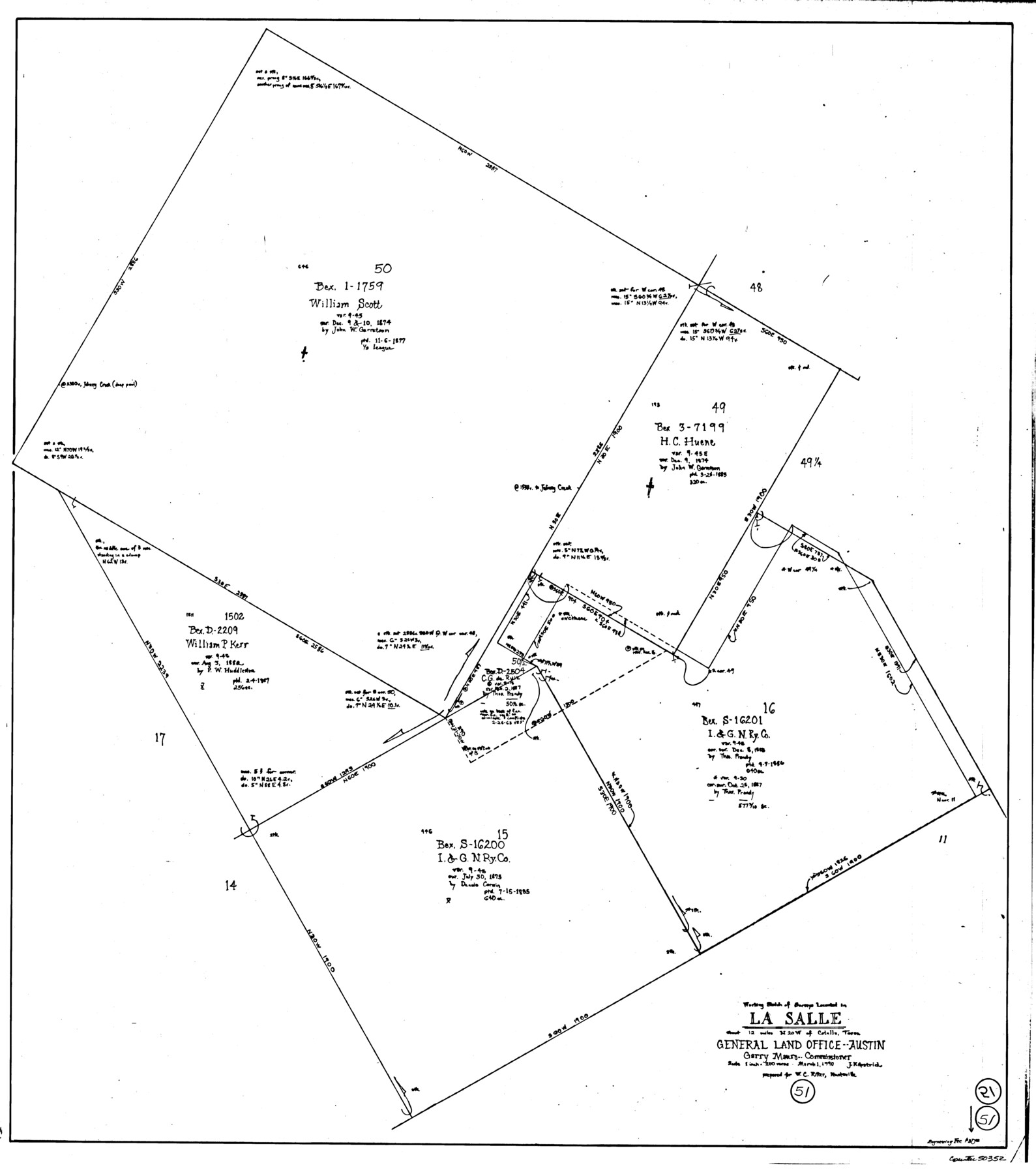
La Salle County Working Sketch 51
-
Map/Doc
70352
-
Collection
General Map Collection
-
Object Dates
3/1/1990 (Creation Date)
-
People and Organizations
Joan Kilpatrick (Draftsman)
-
Counties
La Salle
-
Subjects
Surveying Working Sketch
-
Height x Width
33.9 x 29.9 inches
86.1 x 76.0 cm
-
Scale
1" = 200 varas
Part of: General Map Collection
Dimmit County Sketch File 44

Print $20.00
- Digital $50.00
Dimmit County Sketch File 44
Size 16.3 x 19.5 inches
Map/Doc 11354
Hutchinson County Sketch File 33

Print $20.00
- Digital $50.00
Hutchinson County Sketch File 33
1926
Size 26.5 x 24.5 inches
Map/Doc 11821
Duval County Working Sketch 54

Print $20.00
- Digital $50.00
Duval County Working Sketch 54
1950
Size 14.1 x 19.8 inches
Map/Doc 68778
Houston County Sketch File 6a

Print $4.00
- Digital $50.00
Houston County Sketch File 6a
Size 10.2 x 8.1 inches
Map/Doc 26762
[Surveys in the Bexar District along the San Antonio River showing the position of the missions]
![125, [Surveys in the Bexar District along the San Antonio River showing the position of the missions], General Map Collection](https://historictexasmaps.com/wmedia_w700/maps/125.tif.jpg)
Print $3.00
- Digital $50.00
[Surveys in the Bexar District along the San Antonio River showing the position of the missions]
1841
Size 11.2 x 16.0 inches
Map/Doc 125
Travis County Working Sketch 30

Print $20.00
- Digital $50.00
Travis County Working Sketch 30
1963
Size 30.5 x 35.1 inches
Map/Doc 69414
Flight Mission No. BRE-1P, Frame 76, Nueces County

Print $20.00
- Digital $50.00
Flight Mission No. BRE-1P, Frame 76, Nueces County
1956
Size 18.6 x 22.4 inches
Map/Doc 86658
Hudspeth County Working Sketch 44

Print $20.00
- Digital $50.00
Hudspeth County Working Sketch 44
1982
Size 25.5 x 22.2 inches
Map/Doc 66329
Angelina County Sketch File 9

Print $23.00
- Digital $50.00
Angelina County Sketch File 9
1858
Size 12.3 x 15.8 inches
Map/Doc 10813
Red River, Kelsey Sheet, Upshur County

Print $4.00
- Digital $50.00
Red River, Kelsey Sheet, Upshur County
1933
Size 21.1 x 24.2 inches
Map/Doc 65056
Sterling County Boundary File 1

Print $56.00
- Digital $50.00
Sterling County Boundary File 1
Size 9.0 x 8.7 inches
Map/Doc 58919
Hudspeth County Rolled Sketch 66

Print $20.00
- Digital $50.00
Hudspeth County Rolled Sketch 66
1973
Size 12.1 x 18.7 inches
Map/Doc 6261
You may also like
Chambers County Sketch File 43

Print $13.00
- Digital $50.00
Chambers County Sketch File 43
Size 14.3 x 9.6 inches
Map/Doc 17729
Dickens County

Print $20.00
- Digital $50.00
Dickens County
1915
Size 42.4 x 39.3 inches
Map/Doc 4722
[Block 1PD and Vicinity]
![91536, [Block 1PD and Vicinity], Twichell Survey Records](https://historictexasmaps.com/wmedia_w700/maps/91536-1.tif.jpg)
Print $3.00
- Digital $50.00
[Block 1PD and Vicinity]
Size 11.4 x 9.7 inches
Map/Doc 91536
Gregg County Working Sketch 17

Print $20.00
- Digital $50.00
Gregg County Working Sketch 17
1950
Size 29.7 x 26.2 inches
Map/Doc 63284
Jasper County Boundary File 3

Print $54.00
- Digital $50.00
Jasper County Boundary File 3
Size 9.3 x 31.0 inches
Map/Doc 55480
Map of Webb County

Print $20.00
- Digital $50.00
Map of Webb County
1888
Size 33.6 x 27.7 inches
Map/Doc 4128
Crockett County Rolled Sketch 39
Print $20.00
- Digital $50.00
Crockett County Rolled Sketch 39
1935
Size 30.3 x 43.0 inches
Map/Doc 8705
Reeves County Rolled Sketch 40

Print $20.00
- Digital $50.00
Reeves County Rolled Sketch 40
2019
Size 18.1 x 24.2 inches
Map/Doc 95826
Nueces County Rolled Sketch 67

Print $20.00
- Digital $50.00
Nueces County Rolled Sketch 67
1979
Size 25.4 x 36.9 inches
Map/Doc 6918
Presidio County Rolled Sketch WR

Print $20.00
- Digital $50.00
Presidio County Rolled Sketch WR
1927
Size 35.5 x 33.2 inches
Map/Doc 7420
[Blocks 24, B9, 3KA]
![90326, [Blocks 24, B9, 3KA], Twichell Survey Records](https://historictexasmaps.com/wmedia_w700/maps/90326-1.tif.jpg)
Print $20.00
- Digital $50.00
[Blocks 24, B9, 3KA]
Size 18.2 x 14.0 inches
Map/Doc 90326
Grayson County Rolled Sketch 1

Print $20.00
- Digital $50.00
Grayson County Rolled Sketch 1
1944
Size 43.4 x 29.0 inches
Map/Doc 6029