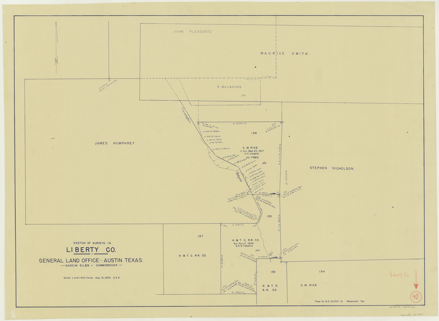
Liberty County Working Sketch 40
-
Map/Doc
70499
-
Collection
General Map Collection
-
Object Dates
8/15/1952 (Creation Date)
-
People and Organizations
Otto G. Kurio (Draftsman)
-
Counties
Liberty
-
Subjects
Surveying Working Sketch
-
Height x Width
24.1 x 32.9 inches
61.2 x 83.6 cm
-
Scale
1" = 400 varas
Part of: General Map Collection
Andrews County Working Sketch 13

Print $20.00
- Digital $50.00
Andrews County Working Sketch 13
1956
Size 37.3 x 30.6 inches
Map/Doc 67059
Wichita County Sketch File 35

Print $8.00
- Digital $50.00
Wichita County Sketch File 35
1950
Size 14.3 x 8.5 inches
Map/Doc 40157
Map of Crockett County

Print $40.00
- Digital $50.00
Map of Crockett County
1878
Size 60.2 x 97.2 inches
Map/Doc 78701
Webb County Rolled Sketch 23

Print $40.00
- Digital $50.00
Webb County Rolled Sketch 23
Size 138.8 x 38.2 inches
Map/Doc 10121
Liberty County Working Sketch 14

Print $20.00
- Digital $50.00
Liberty County Working Sketch 14
1919
Size 17.0 x 25.4 inches
Map/Doc 70473
Flight Mission No. BRA-16M, Frame 161, Jefferson County

Print $20.00
- Digital $50.00
Flight Mission No. BRA-16M, Frame 161, Jefferson County
1953
Size 18.5 x 22.3 inches
Map/Doc 85759
Flight Mission No. DQN-2K, Frame 9, Calhoun County

Print $20.00
- Digital $50.00
Flight Mission No. DQN-2K, Frame 9, Calhoun County
1953
Size 15.7 x 15.6 inches
Map/Doc 84226
Flight Mission No. DQO-7K, Frame 104, Galveston County

Print $20.00
- Digital $50.00
Flight Mission No. DQO-7K, Frame 104, Galveston County
1952
Size 18.7 x 22.4 inches
Map/Doc 85119
Carte du Chemin de Fer de Galveston, Houston et Henderson

Print $20.00
- Digital $50.00
Carte du Chemin de Fer de Galveston, Houston et Henderson
1857
Size 35.4 x 27.2 inches
Map/Doc 89274
1968 Texas Official State Highway Map

Digital $50.00
1968 Texas Official State Highway Map
Size 28.2 x 36.3 inches
Map/Doc 94320
Kerr County State Real Property Sketch 2

Print $2.00
- Digital $50.00
Kerr County State Real Property Sketch 2
2007
Size 10.7 x 8.6 inches
Map/Doc 88675
Travis County Sketch File 73

Print $8.00
- Digital $50.00
Travis County Sketch File 73
1848
Size 12.8 x 8.3 inches
Map/Doc 38464
You may also like
Navarro County Working Sketch 12

Print $40.00
- Digital $50.00
Navarro County Working Sketch 12
1979
Size 37.2 x 48.8 inches
Map/Doc 71242
Kinney County Working Sketch 55

Print $20.00
- Digital $50.00
Kinney County Working Sketch 55
1982
Size 25.1 x 24.7 inches
Map/Doc 70237
Upton County Working Sketch 45

Print $20.00
- Digital $50.00
Upton County Working Sketch 45
1968
Size 44.2 x 38.2 inches
Map/Doc 69541
Webb County Working Sketch 11

Print $20.00
- Digital $50.00
Webb County Working Sketch 11
1921
Size 17.8 x 16.3 inches
Map/Doc 72376
Office sketch of surveys on St. Joseph Island and Mustang Island in Aransas & Nueces Cos.

Print $20.00
- Digital $50.00
Office sketch of surveys on St. Joseph Island and Mustang Island in Aransas & Nueces Cos.
1978
Size 42.8 x 17.7 inches
Map/Doc 2252
General Highway Map, Val Verde County, Texas

Print $20.00
General Highway Map, Val Verde County, Texas
1940
Size 25.0 x 18.4 inches
Map/Doc 79266
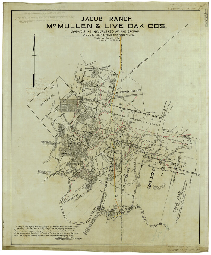
McMullen County Rolled Sketch 2
Print $20.00
- Digital $50.00
McMullen County Rolled Sketch 2
1922
Size 30.3 x 25.2 inches
Map/Doc 6721
[Blocks T2, T3, and K13]
![90997, [Blocks T2, T3, and K13], Twichell Survey Records](https://historictexasmaps.com/wmedia_w700/maps/90997-1.tif.jpg)
Print $20.00
- Digital $50.00
[Blocks T2, T3, and K13]
Size 20.7 x 19.9 inches
Map/Doc 90997
Harris County Sketch File 69b

Print $20.00
- Digital $50.00
Harris County Sketch File 69b
1938
Size 25.3 x 18.9 inches
Map/Doc 11664
Andrews County Rolled Sketch 33

Print $40.00
- Digital $50.00
Andrews County Rolled Sketch 33
Size 131.2 x 22.0 inches
Map/Doc 9003
Panola County Sketch File 28

Print $20.00
- Digital $50.00
Panola County Sketch File 28
1859
Size 22.8 x 22.2 inches
Map/Doc 12142
Grayson County Rolled Sketch 3

Print $20.00
- Digital $50.00
Grayson County Rolled Sketch 3
1952
Size 33.7 x 46.1 inches
Map/Doc 9666