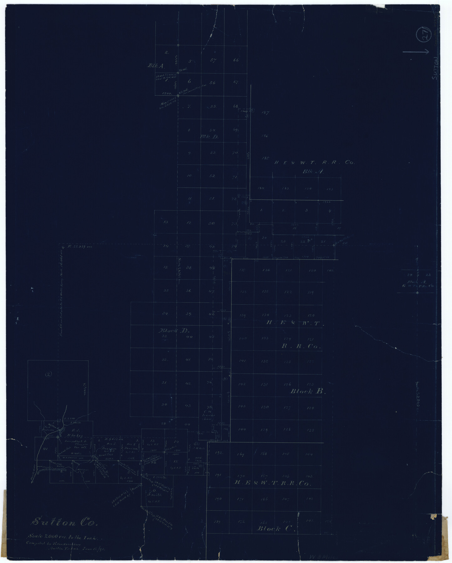
Sutton County Working Sketch 27
-
Map/Doc
62370
-
Collection
General Map Collection
-
Object Dates
6/12/1891 (Creation Date)
-
People and Organizations
E. von Rosenberg (Draftsman)
-
Counties
Sutton
-
Subjects
Surveying Working Sketch
-
Height x Width
23.2 x 18.6 inches
58.9 x 47.2 cm
-
Scale
1" = 2000 varas
Part of: General Map Collection
Flight Mission No. DQO-3K, Frame 37, Galveston County

Print $20.00
- Digital $50.00
Flight Mission No. DQO-3K, Frame 37, Galveston County
1952
Size 18.7 x 22.6 inches
Map/Doc 85078
Dawson County Sketch File 13

Print $2.00
- Digital $50.00
Dawson County Sketch File 13
Size 11.2 x 8.6 inches
Map/Doc 20546
[Sketch for Mineral Application 27670 - Strip between Simon Sanchez leagues and Trinity River]
![65646, [Sketch for Mineral Application 27670 - Strip between Simon Sanchez leagues and Trinity River], General Map Collection](https://historictexasmaps.com/wmedia_w700/maps/65646.tif.jpg)
Print $40.00
- Digital $50.00
[Sketch for Mineral Application 27670 - Strip between Simon Sanchez leagues and Trinity River]
Size 55.5 x 17.8 inches
Map/Doc 65646
Presidio County Sketch File 91

Print $40.00
- Digital $50.00
Presidio County Sketch File 91
Size 12.3 x 15.9 inches
Map/Doc 34763

Anderson County Boundary File 1

Print $10.00
- Digital $50.00
Anderson County Boundary File 1
Size 14.2 x 8.6 inches
Map/Doc 49726
Montgomery County Sketch File 1

Print $4.00
- Digital $50.00
Montgomery County Sketch File 1
Size 11.4 x 8.0 inches
Map/Doc 31762
Hutchinson County Rolled Sketch 43

Print $40.00
- Digital $50.00
Hutchinson County Rolled Sketch 43
1992
Size 40.5 x 49.4 inches
Map/Doc 6312
Calhoun County Working Sketch 11

Print $20.00
- Digital $50.00
Calhoun County Working Sketch 11
1952
Size 43.1 x 34.9 inches
Map/Doc 67827
Harris County Working Sketch 69

Print $20.00
- Digital $50.00
Harris County Working Sketch 69
1956
Size 32.7 x 28.2 inches
Map/Doc 65961
Webb County Boundary File 3b

Print $82.00
- Digital $50.00
Webb County Boundary File 3b
Size 20.3 x 50.8 inches
Map/Doc 59758
Map of Erath County

Print $20.00
- Digital $50.00
Map of Erath County
1872
Size 20.2 x 19.8 inches
Map/Doc 3521
You may also like
[I. Killough and Hiram Cates surveys and vicinity]
![91851, [I. Killough and Hiram Cates surveys and vicinity], Twichell Survey Records](https://historictexasmaps.com/wmedia_w700/maps/91851-1.tif.jpg)
Print $20.00
- Digital $50.00
[I. Killough and Hiram Cates surveys and vicinity]
Size 27.5 x 9.2 inches
Map/Doc 91851
McLennan County Sketch File 9

Print $4.00
- Digital $50.00
McLennan County Sketch File 9
1849
Size 12.5 x 8.1 inches
Map/Doc 31258
Flight Mission No. BQR-4K, Frame 65, Brazoria County

Print $20.00
- Digital $50.00
Flight Mission No. BQR-4K, Frame 65, Brazoria County
1952
Size 18.5 x 22.3 inches
Map/Doc 83998
General Highway Map, Jefferson County, Texas

Print $20.00
General Highway Map, Jefferson County, Texas
1961
Size 24.6 x 18.3 inches
Map/Doc 79537
Childress County Rolled Sketch 18

Print $20.00
- Digital $50.00
Childress County Rolled Sketch 18
1913
Size 17.6 x 39.0 inches
Map/Doc 5451
[Surveys in Austin's Colony along the Navidad River; John P. Borden for Thos. H. Borden]
![77, [Surveys in Austin's Colony along the Navidad River; John P. Borden for Thos. H. Borden], General Map Collection](https://historictexasmaps.com/wmedia_w700/maps/77.tif.jpg)
Print $20.00
- Digital $50.00
[Surveys in Austin's Colony along the Navidad River; John P. Borden for Thos. H. Borden]
1831
Size 20.6 x 9.3 inches
Map/Doc 77
[John H. Gibson Block D Showing Patented Sections]
![92450, [John H. Gibson Block D Showing Patented Sections], Twichell Survey Records](https://historictexasmaps.com/wmedia_w700/maps/92450-1.tif.jpg)
Print $20.00
- Digital $50.00
[John H. Gibson Block D Showing Patented Sections]
Size 14.7 x 16.1 inches
Map/Doc 92450
[Block A, Greer County, Texas]
![384, [Block A, Greer County, Texas], Maddox Collection](https://historictexasmaps.com/wmedia_w700/maps/384.tif.jpg)
Print $20.00
- Digital $50.00
[Block A, Greer County, Texas]
Size 16.9 x 15.8 inches
Map/Doc 384
Map of portion of Galveston Bay in Chambers & Galveston Counties showing subdivision thereof for mineral development

Print $20.00
- Digital $50.00
Map of portion of Galveston Bay in Chambers & Galveston Counties showing subdivision thereof for mineral development
1938
Size 15.3 x 19.2 inches
Map/Doc 2935
Flight Mission No. 29300074, Harris County

Print $20.00
- Digital $50.00
Flight Mission No. 29300074, Harris County
1985
Size 10.4 x 10.4 inches
Map/Doc 85286

Plat of South Side Addition on Section 37 Block 17, Wheeler County, Texas

Print $20.00
- Digital $50.00
Plat of South Side Addition on Section 37 Block 17, Wheeler County, Texas
Size 12.0 x 16.9 inches
Map/Doc 92103