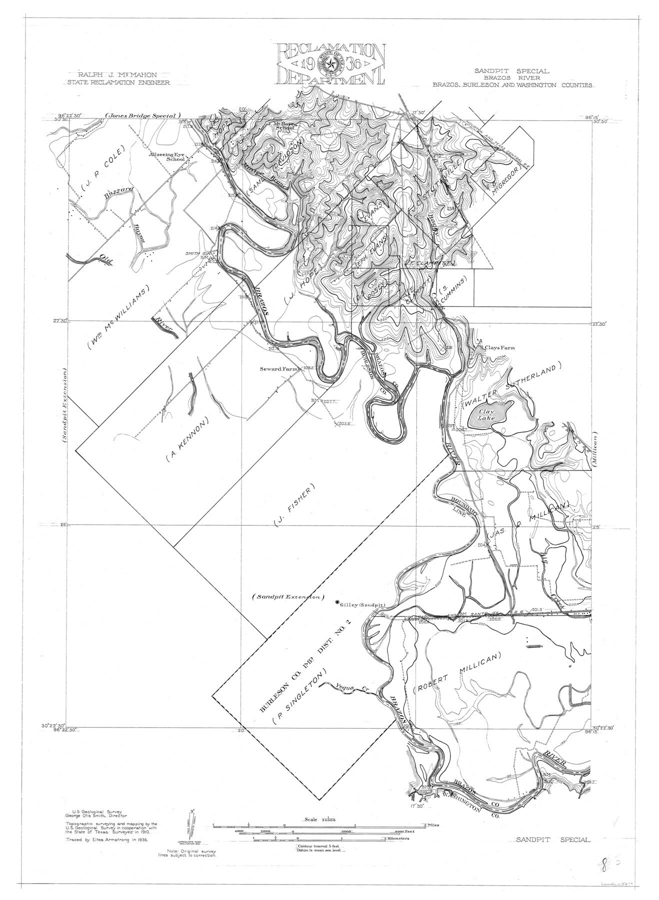
Brazos River, Sandpit Special Sheet
-
Map/Doc
65279
-
Collection
General Map Collection
-
Object Dates
1936 (Creation Date)
-
People and Organizations
Texas State Reclamation Department (Publisher)
Eltea Armstrong (Draftsman)
Eltea Armstrong (Compiler)
-
Counties
Brazos Burleson Washington
-
Subjects
River Surveys Topographic
-
Height x Width
33.8 x 24.7 inches
85.9 x 62.7 cm
-
Comments
Sandpit Special Sheet located south of the Jones Bridge Special Sheet, west of the Millican Sheet and east of the Sandpit Extension Sheet.
Part of: General Map Collection
Flight Mission No. CRC-4R, Frame 81, Chambers County

Print $20.00
- Digital $50.00
Flight Mission No. CRC-4R, Frame 81, Chambers County
1956
Size 18.7 x 22.5 inches
Map/Doc 84885
Flight Mission No. CLL-1N, Frame 76, Willacy County

Print $20.00
- Digital $50.00
Flight Mission No. CLL-1N, Frame 76, Willacy County
1954
Size 18.3 x 22.0 inches
Map/Doc 87022
Lamar County Sketch File 5

Print $4.00
- Digital $50.00
Lamar County Sketch File 5
1877
Size 4.8 x 8.1 inches
Map/Doc 29284
Rusk County Rolled Sketch 9A

Print $20.00
- Digital $50.00
Rusk County Rolled Sketch 9A
1971
Size 30.4 x 19.1 inches
Map/Doc 7547
Anderson County Sketch File 4

Print $6.00
- Digital $50.00
Anderson County Sketch File 4
Size 8.7 x 6.4 inches
Map/Doc 12743
Map of Colorado County

Print $20.00
- Digital $50.00
Map of Colorado County
1881
Size 22.5 x 21.4 inches
Map/Doc 3427
Carson County Boundary File 8

Print $40.00
- Digital $50.00
Carson County Boundary File 8
Size 7.8 x 35.0 inches
Map/Doc 51171
Hopkins County Sketch File 4

Print $47.00
- Digital $50.00
Hopkins County Sketch File 4
Size 21.2 x 18.4 inches
Map/Doc 4565
Harris County Working Sketch 67

Print $20.00
- Digital $50.00
Harris County Working Sketch 67
1955
Size 23.3 x 27.5 inches
Map/Doc 65959
Dallas County Boundary File 4a

Print $60.00
- Digital $50.00
Dallas County Boundary File 4a
Size 14.0 x 8.4 inches
Map/Doc 52142
Lampasas County Working Sketch 24

Print $20.00
- Digital $50.00
Lampasas County Working Sketch 24
Size 14.3 x 13.3 inches
Map/Doc 61796
Flight Mission No. DIX-8P, Frame 95, Aransas County

Print $20.00
- Digital $50.00
Flight Mission No. DIX-8P, Frame 95, Aransas County
1956
Size 18.4 x 22.3 inches
Map/Doc 83920
You may also like
Hall County Sketch File 32

Print $14.00
- Digital $50.00
Hall County Sketch File 32
1911
Size 11.2 x 8.8 inches
Map/Doc 24839
Walker County Sketch File 2

Print $6.00
- Digital $50.00
Walker County Sketch File 2
1854
Size 10.5 x 15.9 inches
Map/Doc 39549
Bandera County Working Sketch 49

Print $20.00
- Digital $50.00
Bandera County Working Sketch 49
1983
Size 28.2 x 43.3 inches
Map/Doc 67645
Brewster County Rolled Sketch 60

Print $20.00
- Digital $50.00
Brewster County Rolled Sketch 60
Size 24.8 x 36.5 inches
Map/Doc 61783
Castro County

Print $20.00
- Digital $50.00
Castro County
1932
Size 43.4 x 38.6 inches
Map/Doc 73102
Calhoun County NRC Article 33.136 Location Key Sheet

Print $20.00
- Digital $50.00
Calhoun County NRC Article 33.136 Location Key Sheet
1973
Size 27.0 x 23.0 inches
Map/Doc 87906

Flight Mission No. DIX-10P, Frame 147, Aransas County

Print $20.00
- Digital $50.00
Flight Mission No. DIX-10P, Frame 147, Aransas County
1956
Size 18.7 x 22.4 inches
Map/Doc 83949
Flight Mission No. BQR-22K, Frame 40, Brazoria County

Print $20.00
- Digital $50.00
Flight Mission No. BQR-22K, Frame 40, Brazoria County
1953
Size 18.6 x 22.3 inches
Map/Doc 84124
Land fur Federmann und eine Heimath fur Heimathlose!

Land fur Federmann und eine Heimath fur Heimathlose!
1901
Map/Doc 96749
Rand, McNally & Co.'s Texas

Print $20.00
- Digital $50.00
Rand, McNally & Co.'s Texas
1895
Size 21.2 x 28.6 inches
Map/Doc 95885
Trinity County

Print $20.00
- Digital $50.00
Trinity County
1946
Size 42.7 x 43.2 inches
Map/Doc 95656