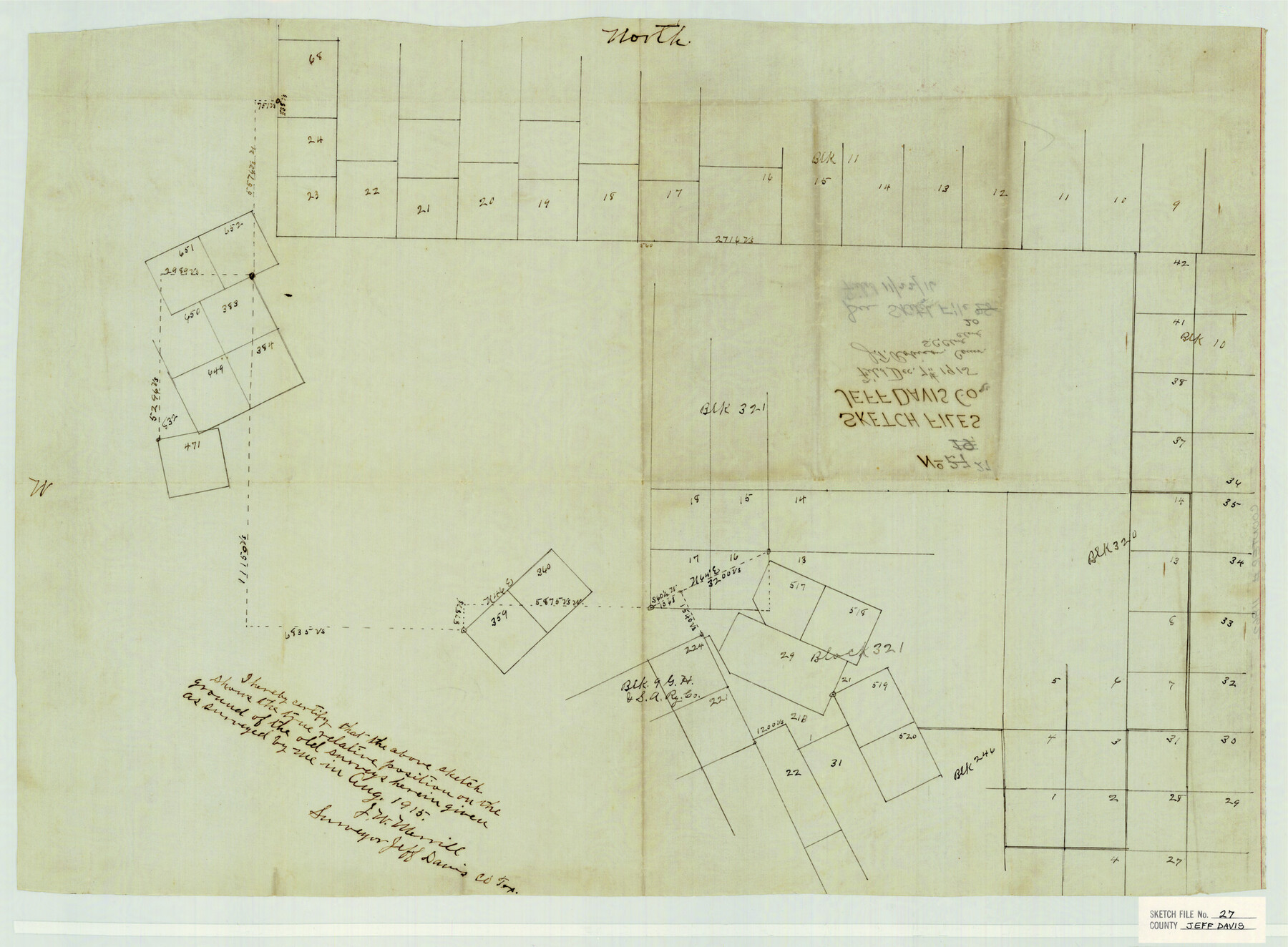
Jeff Davis County Sketch File 27
[Sketch of surveys in the eastern corner of the county]
-
Map/Doc
11862
-
Collection
General Map Collection
-
Object Dates
1915 (Creation Date)
12/7/1915 (File Date)
8/1915 (Survey Date)
-
People and Organizations
J.W. Merrill (Surveyor/Engineer)
-
Counties
Jeff Davis Brewster
-
Subjects
Surveying Sketch File
-
Height x Width
18.8 x 25.5 inches
47.8 x 64.8 cm
-
Medium
paper, manuscript
Part of: General Map Collection
Maps & Lists Showing Prison Lands (Oil & Gas) Leased as of June 1955

Digital $50.00
Maps & Lists Showing Prison Lands (Oil & Gas) Leased as of June 1955
Size 11.2 x 8.8 inches
Map/Doc 62874
Brazos River, Widths of Floodways/Brazos and Navasota Rivers

Print $20.00
- Digital $50.00
Brazos River, Widths of Floodways/Brazos and Navasota Rivers
1921
Size 38.1 x 24.5 inches
Map/Doc 65292
Intracoastal Waterway in Texas - Corpus Christi to Point Isabel including Arroyo Colorado to Mo. Pac. R.R. Bridge Near Harlingen

Print $20.00
- Digital $50.00
Intracoastal Waterway in Texas - Corpus Christi to Point Isabel including Arroyo Colorado to Mo. Pac. R.R. Bridge Near Harlingen
1933
Size 28.2 x 40.7 inches
Map/Doc 61855
Flight Mission No. CRC-3R, Frame 11, Chambers County

Print $20.00
- Digital $50.00
Flight Mission No. CRC-3R, Frame 11, Chambers County
1956
Size 18.7 x 22.4 inches
Map/Doc 84785
Andrews County

Print $40.00
- Digital $50.00
Andrews County
1925
Size 42.3 x 55.4 inches
Map/Doc 4778
Upton County Sketch File 14CF

Print $8.00
- Digital $50.00
Upton County Sketch File 14CF
1926
Size 11.3 x 8.8 inches
Map/Doc 38860
Foard County Boundary File 2a

Print $40.00
- Digital $50.00
Foard County Boundary File 2a
Size 33.2 x 14.7 inches
Map/Doc 53514
Sketch of Robertson Co., Tehuacana Creek

Print $3.00
- Digital $50.00
Sketch of Robertson Co., Tehuacana Creek
1846
Size 10.3 x 16.4 inches
Map/Doc 264
Midland County Sketch File 1

Print $20.00
- Digital $50.00
Midland County Sketch File 1
1886
Size 25.7 x 16.1 inches
Map/Doc 12079
Terrell County Working Sketch 77

Print $20.00
- Digital $50.00
Terrell County Working Sketch 77
1983
Size 22.9 x 33.7 inches
Map/Doc 69598
Red River County Sketch File 2

Print $8.00
- Digital $50.00
Red River County Sketch File 2
1852
Size 12.9 x 8.5 inches
Map/Doc 35095
Edwards County Working Sketch 102

Print $20.00
- Digital $50.00
Edwards County Working Sketch 102
1971
Size 35.0 x 25.5 inches
Map/Doc 68978
You may also like
Travis County Appraisal District Plat Map 2_0404

Print $20.00
- Digital $50.00
Travis County Appraisal District Plat Map 2_0404
Size 21.5 x 26.4 inches
Map/Doc 94229
Live Oak County Working Sketch 39

Print $40.00
- Digital $50.00
Live Oak County Working Sketch 39
2006
Size 36.4 x 48.6 inches
Map/Doc 94156
Henderson County Sketch File 4

Print $4.00
- Digital $50.00
Henderson County Sketch File 4
1851
Size 12.9 x 8.3 inches
Map/Doc 26323
Tom Green County Sketch File 66

Print $22.00
- Digital $50.00
Tom Green County Sketch File 66
1929
Size 16.8 x 14.6 inches
Map/Doc 38236
Flight Mission No. DIX-8P, Frame 83, Aransas County

Print $20.00
- Digital $50.00
Flight Mission No. DIX-8P, Frame 83, Aransas County
1956
Size 18.6 x 22.3 inches
Map/Doc 83908
Armstrong County Rolled Sketch ACP

Print $20.00
- Digital $50.00
Armstrong County Rolled Sketch ACP
1900
Size 33.0 x 35.3 inches
Map/Doc 8425
Kinney County Working Sketch 53

Print $4.00
- Digital $50.00
Kinney County Working Sketch 53
1981
Size 23.7 x 23.0 inches
Map/Doc 70235
Upton County Boundary File 1

Print $5.00
- Digital $50.00
Upton County Boundary File 1
Size 13.4 x 9.0 inches
Map/Doc 59506
Cass County Working Sketch 29

Print $20.00
- Digital $50.00
Cass County Working Sketch 29
1979
Size 38.4 x 23.5 inches
Map/Doc 67932
Dépt. des Basses-Alpes

Print $20.00
- Digital $50.00
Dépt. des Basses-Alpes
Size 13.9 x 20.3 inches
Map/Doc 94450
Robertson County Sketch File 1

Print $7.00
- Digital $50.00
Robertson County Sketch File 1
1857
Size 12.8 x 8.2 inches
Map/Doc 35340
Kleberg County Rolled Sketch 10-21

Print $20.00
- Digital $50.00
Kleberg County Rolled Sketch 10-21
1952
Size 37.5 x 32.9 inches
Map/Doc 9403