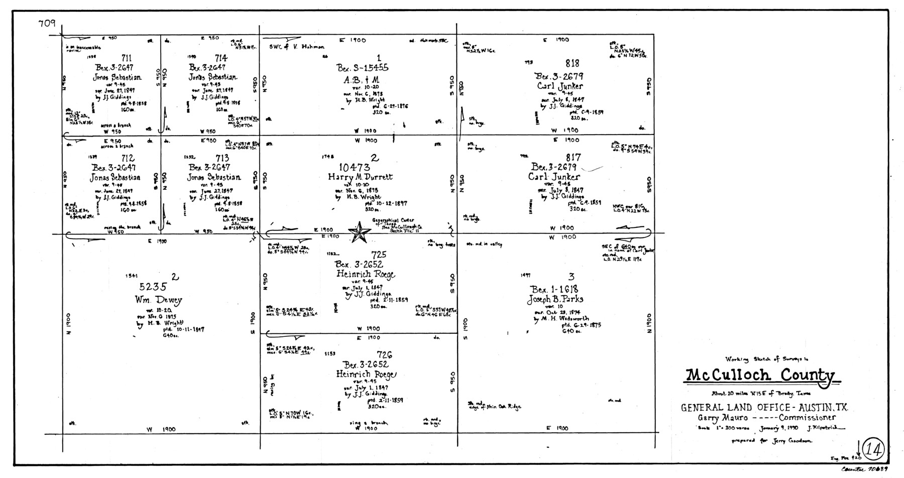
McCulloch County Working Sketch 14
-
Map/Doc
70689
-
Collection
General Map Collection
-
Object Dates
1/9/1990 (Creation Date)
-
People and Organizations
Joan Kilpatrick (Draftsman)
-
Counties
McCulloch
-
Subjects
Surveying Working Sketch
-
Height x Width
15.3 x 29.0 inches
38.9 x 73.7 cm
-
Scale
1" = 300 varas
Part of: General Map Collection
Current Miscellaneous File 10

Print $8.00
- Digital $50.00
Current Miscellaneous File 10
1916
Size 11.4 x 8.8 inches
Map/Doc 73774
Travis County Appraisal District Plat Map 2_1709

Print $20.00
- Digital $50.00
Travis County Appraisal District Plat Map 2_1709
Size 21.6 x 26.5 inches
Map/Doc 94210
Texas-Indian Territory Denison Quadrangle

Print $20.00
- Digital $50.00
Texas-Indian Territory Denison Quadrangle
1901
Size 20.1 x 16.7 inches
Map/Doc 75110
Jeff Davis County Working Sketch 30

Print $20.00
- Digital $50.00
Jeff Davis County Working Sketch 30
1969
Size 36.1 x 31.2 inches
Map/Doc 66525
Sketch of coast of Texas, Laguna Madre from Pt. of Rocks to Corpus Christi [and accompanying letter]
![72963, Sketch of coast of Texas, Laguna Madre from Pt. of Rocks to Corpus Christi [and accompanying letter], General Map Collection](https://historictexasmaps.com/wmedia_w700/maps/72963.tif.jpg)
Print $2.00
- Digital $50.00
Sketch of coast of Texas, Laguna Madre from Pt. of Rocks to Corpus Christi [and accompanying letter]
1882
Size 11.2 x 8.8 inches
Map/Doc 72963
The Cotton Kingdom: a Traveller's Observations on Cotton and Slavery in the American Slave States

The Cotton Kingdom: a Traveller's Observations on Cotton and Slavery in the American Slave States
Map/Doc 96571
Somervell County Rolled Sketch A

Print $20.00
- Digital $50.00
Somervell County Rolled Sketch A
Size 14.8 x 15.2 inches
Map/Doc 75999
Flight Mission No. DAG-21K, Frame 43, Matagorda County

Print $20.00
- Digital $50.00
Flight Mission No. DAG-21K, Frame 43, Matagorda County
1952
Size 18.9 x 22.6 inches
Map/Doc 86410
Harbor Pass and Bar at Brazos Santiago, Texas

Print $20.00
- Digital $50.00
Harbor Pass and Bar at Brazos Santiago, Texas
1871
Size 18.2 x 26.8 inches
Map/Doc 72983
Pecos County Working Sketch 62

Print $40.00
- Digital $50.00
Pecos County Working Sketch 62
1952
Size 32.3 x 59.1 inches
Map/Doc 71534
Wharton County Rolled Sketch 11

Print $20.00
- Digital $50.00
Wharton County Rolled Sketch 11
Size 27.7 x 37.1 inches
Map/Doc 8236
Fort Bend County State Real Property Sketch 2

Print $40.00
- Digital $50.00
Fort Bend County State Real Property Sketch 2
1986
Size 34.8 x 43.4 inches
Map/Doc 61676
You may also like
Chambers County Sketch File 35a

Print $31.00
- Digital $50.00
Chambers County Sketch File 35a
1935
Size 15.4 x 9.1 inches
Map/Doc 17632
[Galveston, Harrisburg & San Antonio from El Paso to El Paso-Presidio county boundary]
![64719, [Galveston, Harrisburg & San Antonio from El Paso to El Paso-Presidio county boundary], General Map Collection](https://historictexasmaps.com/wmedia_w700/maps/64719.tif.jpg)
Print $40.00
- Digital $50.00
[Galveston, Harrisburg & San Antonio from El Paso to El Paso-Presidio county boundary]
Size 150.0 x 27.3 inches
Map/Doc 64719
Map of Retrieve Plantation, Brazoria County, Texas

Print $20.00
- Digital $50.00
Map of Retrieve Plantation, Brazoria County, Texas
Size 26.6 x 28.5 inches
Map/Doc 62999
The Republic County of Victoria. Proposed, Late Fall 1837-September 18, 1838

Print $20.00
The Republic County of Victoria. Proposed, Late Fall 1837-September 18, 1838
2020
Size 22.5 x 21.7 inches
Map/Doc 96295
San Saba County Sketch File 2

Print $6.00
- Digital $50.00
San Saba County Sketch File 2
1854
Size 4.8 x 7.4 inches
Map/Doc 36405
[Capitol Leagues in Southwest Hartley and Northwest Oldham Counties]
![90723, [Capitol Leagues in Southwest Hartley and Northwest Oldham Counties], Twichell Survey Records](https://historictexasmaps.com/wmedia_w700/maps/90723-1.tif.jpg)
Print $20.00
- Digital $50.00
[Capitol Leagues in Southwest Hartley and Northwest Oldham Counties]
Size 13.8 x 18.0 inches
Map/Doc 90723
Comal County Sketch File 1

Print $6.00
- Digital $50.00
Comal County Sketch File 1
1846
Size 16.4 x 10.5 inches
Map/Doc 18995

Walker County Miscellaneous Sketch 1

Print $20.00
- Digital $50.00
Walker County Miscellaneous Sketch 1
2003
Size 36.0 x 31.3 inches
Map/Doc 88868
Flight Mission No. CUG-3P, Frame 39, Kleberg County

Print $20.00
- Digital $50.00
Flight Mission No. CUG-3P, Frame 39, Kleberg County
1956
Size 18.4 x 22.2 inches
Map/Doc 86244
Map of Galveston County

Print $20.00
- Digital $50.00
Map of Galveston County
1864
Size 19.6 x 28.0 inches
Map/Doc 3576
Val Verde County Sketch File Z14

Print $20.00
- Digital $50.00
Val Verde County Sketch File Z14
1899
Size 22.1 x 20.6 inches
Map/Doc 12556