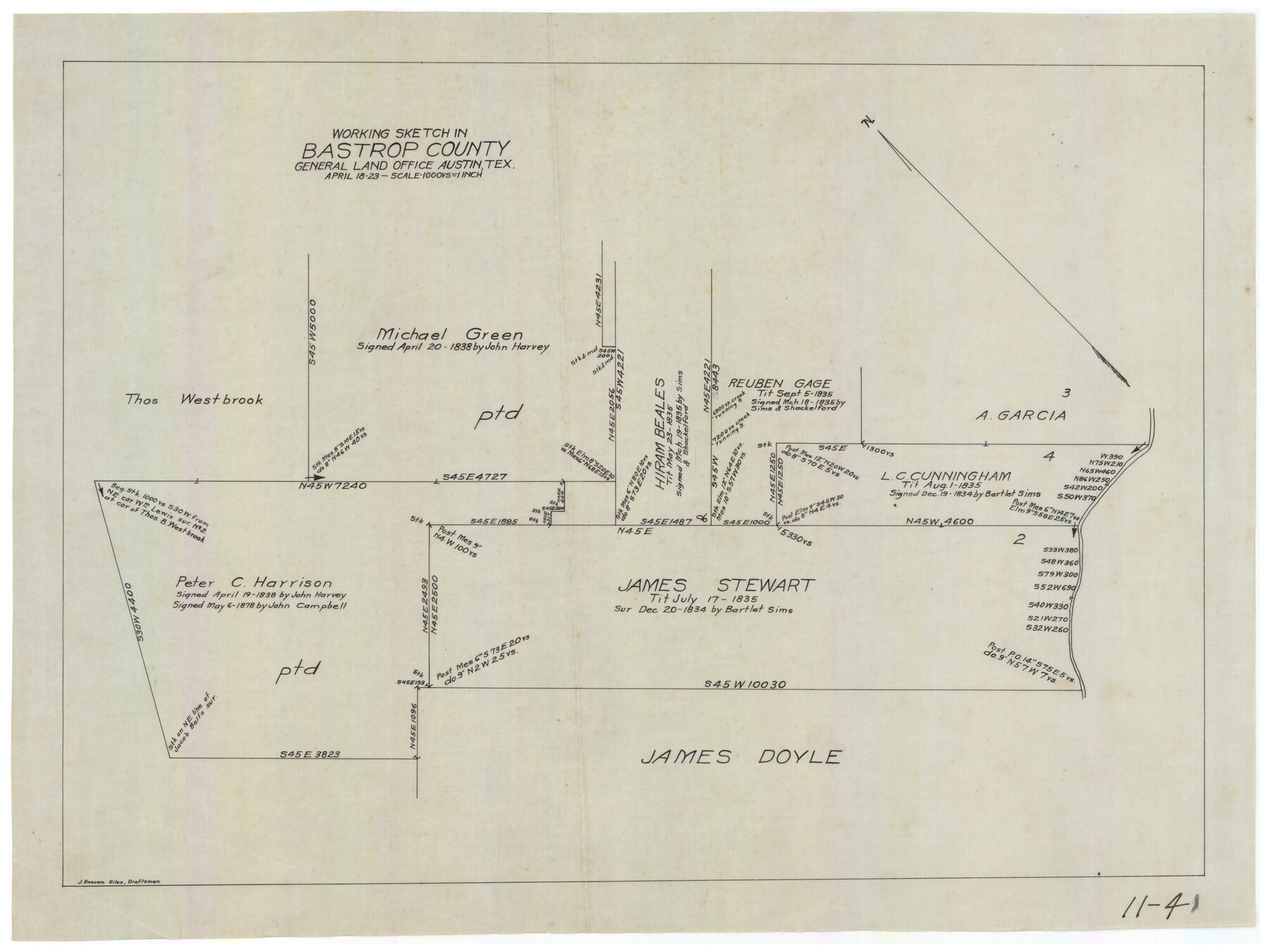
Working Sketch in Bastrop County
11-4
-
Map/Doc
90238
-
Collection
Twichell Survey Records
-
Object Dates
4/18/1923 (Creation Date)
-
People and Organizations
General Land Office (Publisher)
J. Bascom Giles (Draftsman)
-
Counties
Bastrop
-
Height x Width
19.9 x 14.8 inches
50.6 x 37.6 cm
Part of: Twichell Survey Records
[South Line of Block RG]
![91322, [South Line of Block RG], Twichell Survey Records](https://historictexasmaps.com/wmedia_w700/maps/91322-1.tif.jpg)
Print $20.00
- Digital $50.00
[South Line of Block RG]
Size 34.9 x 14.1 inches
Map/Doc 91322
[SW Corner of Lynn County]
![92903, [SW Corner of Lynn County], Twichell Survey Records](https://historictexasmaps.com/wmedia_w700/maps/92903-1.tif.jpg)
Print $20.00
- Digital $50.00
[SW Corner of Lynn County]
1954
Size 32.2 x 31.1 inches
Map/Doc 92903
Eleven County Map

Print $40.00
- Digital $50.00
Eleven County Map
Size 39.2 x 57.5 inches
Map/Doc 89856
[Blocks K3-K8, K11]
![90611, [Blocks K3-K8, K11], Twichell Survey Records](https://historictexasmaps.com/wmedia_w700/maps/90611-1.tif.jpg)
Print $20.00
- Digital $50.00
[Blocks K3-K8, K11]
Size 16.8 x 17.2 inches
Map/Doc 90611
[Sketch of part of G. & M. Block 5]
![93080, [Sketch of part of G. & M. Block 5], Twichell Survey Records](https://historictexasmaps.com/wmedia_w700/maps/93080-1.tif.jpg)
Print $20.00
- Digital $50.00
[Sketch of part of G. & M. Block 5]
Size 26.3 x 18.9 inches
Map/Doc 93080
[Morris County School Land and vicinity]
![90360, [Morris County School Land and vicinity], Twichell Survey Records](https://historictexasmaps.com/wmedia_w700/maps/90360-1.tif.jpg)
Print $20.00
- Digital $50.00
[Morris County School Land and vicinity]
Size 14.2 x 13.0 inches
Map/Doc 90360
[H. & T.C. Blocks 46, 47]
![89927, [H. & T.C. Blocks 46, 47], Twichell Survey Records](https://historictexasmaps.com/wmedia_w700/maps/89927-1.tif.jpg)
Print $20.00
- Digital $50.00
[H. & T.C. Blocks 46, 47]
Size 37.3 x 46.6 inches
Map/Doc 89927
[T. & P. Blocks 43-45, Townships 1S and 1N]
![90878, [T. & P. Blocks 43-45, Townships 1S and 1N], Twichell Survey Records](https://historictexasmaps.com/wmedia_w700/maps/90878-2.tif.jpg)
Print $20.00
- Digital $50.00
[T. & P. Blocks 43-45, Townships 1S and 1N]
Size 22.9 x 18.0 inches
Map/Doc 90878
Shamrock, Amended Plat on Section 44, Block 17, Wheeler County, Texas

Print $20.00
- Digital $50.00
Shamrock, Amended Plat on Section 44, Block 17, Wheeler County, Texas
Size 30.0 x 35.5 inches
Map/Doc 92144
[T.& P. RR Co. Block 32 Township 4 North]
![92455, [T.& P. RR Co. Block 32 Township 4 North], Twichell Survey Records](https://historictexasmaps.com/wmedia_w700/maps/92455-1.tif.jpg)
Print $20.00
- Digital $50.00
[T.& P. RR Co. Block 32 Township 4 North]
Size 35.5 x 19.5 inches
Map/Doc 92455
Map of Survey made for Bascom Giles, General Land Commissioner, covering Bob Reid Mineral Application No. 35521

Print $20.00
- Digital $50.00
Map of Survey made for Bascom Giles, General Land Commissioner, covering Bob Reid Mineral Application No. 35521
1941
Size 26.5 x 19.1 inches
Map/Doc 91964
[Eastern Texas RR. Co. Block 1]
![91922, [Eastern Texas RR. Co. Block 1], Twichell Survey Records](https://historictexasmaps.com/wmedia_w700/maps/91922-1.tif.jpg)
Print $20.00
- Digital $50.00
[Eastern Texas RR. Co. Block 1]
Size 34.7 x 31.0 inches
Map/Doc 91922
You may also like
Baylor County Boundary File 1

Print $25.00
- Digital $50.00
Baylor County Boundary File 1
Size 9.3 x 8.4 inches
Map/Doc 50347
Flight Mission No. DQN-6K, Frame 17, Calhoun County

Print $20.00
- Digital $50.00
Flight Mission No. DQN-6K, Frame 17, Calhoun County
1953
Size 18.5 x 22.1 inches
Map/Doc 84439
Deaf Smith County Rolled Sketch 4

Print $20.00
- Digital $50.00
Deaf Smith County Rolled Sketch 4
Size 23.9 x 18.0 inches
Map/Doc 96789
Map of Wood County, Texas

Print $20.00
- Digital $50.00
Map of Wood County, Texas
1879
Size 17.5 x 17.1 inches
Map/Doc 659
Flight Mission No. BRE-1P, Frame 55, Nueces County

Print $20.00
- Digital $50.00
Flight Mission No. BRE-1P, Frame 55, Nueces County
1956
Size 18.3 x 22.2 inches
Map/Doc 86644
Erath County Working Sketch 33

Print $20.00
- Digital $50.00
Erath County Working Sketch 33
1972
Size 25.1 x 21.0 inches
Map/Doc 69114
Zavala County Sketch File 50

Print $10.00
- Digital $50.00
Zavala County Sketch File 50
1956
Size 14.6 x 9.1 inches
Map/Doc 41446
Map of Orange County

Print $20.00
- Digital $50.00
Map of Orange County
1862
Size 13.6 x 16.5 inches
Map/Doc 3929

Flight Mission No. CRC-2R, Frame 123, Chambers County

Print $20.00
- Digital $50.00
Flight Mission No. CRC-2R, Frame 123, Chambers County
1956
Size 18.6 x 22.4 inches
Map/Doc 84747
Red River County Sketch File A

Print $40.00
- Digital $50.00
Red River County Sketch File A
1900
Size 20.1 x 23.8 inches
Map/Doc 12236
A Map of Louisiana and Mexico

Print $20.00
- Digital $50.00
A Map of Louisiana and Mexico
1820
Size 43.8 x 32.9 inches
Map/Doc 94945