Montgomery County Sketch File 16
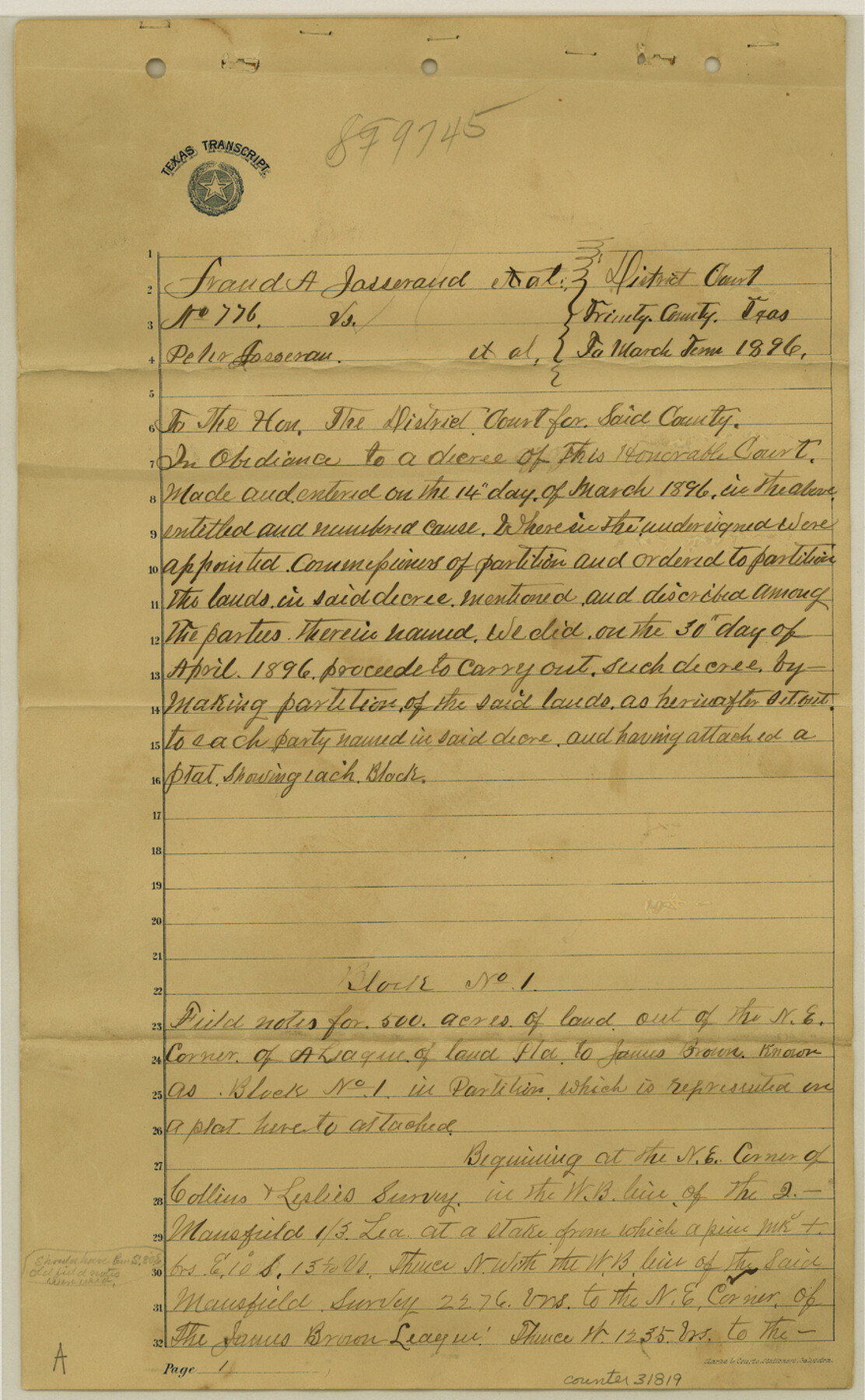
[Protest regarding SF-9745]
-
Map/Doc
31819
-
Collection
General Map Collection
-
Object Dates
3/1896 (Creation Date)
6/17/1911 (File Date)
5/30/1910 (Correspondence Date)
4/1896 (Survey Date)
-
People and Organizations
Dibrell (Surveyor/Engineer)
W.B. Smith (Chainman/Field Personnel)
A.J. Rusk (Chainman/Field Personnel)
Oiver Strive (Chainman/Field Personnel)
L. Burnes (Surveyor/Engineer)
-
Counties
Montgomery
-
Subjects
Surveying Sketch File
-
Height x Width
14.2 x 8.8 inches
36.1 x 22.4 cm
-
Medium
multi-page, multi-format
-
Features
Dry Creek
Spring Creek
Part of: General Map Collection
Madison County

Print $20.00
- Digital $50.00
Madison County
1871
Size 15.2 x 20.3 inches
Map/Doc 4587
Marion County Sketch File 7

Print $40.00
- Digital $50.00
Marion County Sketch File 7
1866
Size 16.2 x 12.0 inches
Map/Doc 30573
Limestone County Working Sketch 2

Print $20.00
- Digital $50.00
Limestone County Working Sketch 2
Size 17.3 x 15.9 inches
Map/Doc 70552
Polk County Sketch File 22

Print $6.00
- Digital $50.00
Polk County Sketch File 22
1887
Size 8.9 x 7.5 inches
Map/Doc 34173
Shelby County Working Sketch 18

Print $20.00
- Digital $50.00
Shelby County Working Sketch 18
1957
Size 20.7 x 27.4 inches
Map/Doc 63871

Cass County Working Sketch 7

Print $20.00
- Digital $50.00
Cass County Working Sketch 7
1937
Size 21.9 x 28.9 inches
Map/Doc 67910
Galveston County Rolled Sketch 30

Print $20.00
- Digital $50.00
Galveston County Rolled Sketch 30
1979
Size 28.0 x 39.8 inches
Map/Doc 5964
[Map of Terrell County]
![4074, [Map of Terrell County], General Map Collection](https://historictexasmaps.com/wmedia_w700/maps/4074.tif.jpg)
Print $20.00
- Digital $50.00
[Map of Terrell County]
Size 38.0 x 24.0 inches
Map/Doc 4074
Trinity River, Mountain Creek Sheet

Print $40.00
- Digital $50.00
Trinity River, Mountain Creek Sheet
1918
Size 51.3 x 34.7 inches
Map/Doc 65211
Dawson County Sketch File 1

Print $6.00
- Digital $50.00
Dawson County Sketch File 1
Size 7.5 x 3.9 inches
Map/Doc 20495
[Surveys along Bosque and Hog Creek]
![238, [Surveys along Bosque and Hog Creek], General Map Collection](https://historictexasmaps.com/wmedia_w700/maps/238.tif.jpg)
Print $20.00
- Digital $50.00
[Surveys along Bosque and Hog Creek]
1845
Size 23.9 x 17.0 inches
Map/Doc 238
You may also like
Austin County Rolled Sketch 5A

Print $40.00
- Digital $50.00
Austin County Rolled Sketch 5A
Size 54.2 x 44.1 inches
Map/Doc 8437
Dimmit County Working Sketch 31

Print $20.00
- Digital $50.00
Dimmit County Working Sketch 31
1959
Size 26.3 x 42.8 inches
Map/Doc 68692
Leon County Rolled Sketch 12

Print $20.00
- Digital $50.00
Leon County Rolled Sketch 12
1974
Size 46.5 x 40.7 inches
Map/Doc 9431
Santa Fe Lines - Texas, Oklahoma, and Louisiana

Print $20.00
- Digital $50.00
Santa Fe Lines - Texas, Oklahoma, and Louisiana
1923
Size 9.3 x 8.3 inches
Map/Doc 96595

[Sketch of surveys north of Jefferson County School Land]
![91890, [Sketch of surveys north of Jefferson County School Land], Twichell Survey Records](https://historictexasmaps.com/wmedia_w700/maps/91890-1.tif.jpg)
Print $3.00
- Digital $50.00
[Sketch of surveys north of Jefferson County School Land]
1891
Size 10.3 x 11.2 inches
Map/Doc 91890
Tierra Blanca Water Conservation Project Dam

Print $20.00
- Digital $50.00
Tierra Blanca Water Conservation Project Dam
1937
Size 37.7 x 25.1 inches
Map/Doc 92157
Nueces County Sketch File 28

Print $6.00
- Digital $50.00
Nueces County Sketch File 28
Size 10.0 x 10.9 inches
Map/Doc 32596
Menard County Working Sketch 9

Print $20.00
- Digital $50.00
Menard County Working Sketch 9
1937
Size 22.9 x 22.5 inches
Map/Doc 70956
Right of Way and Track Map of The Missouri, Kansas & Texas Railway of Texas

Print $40.00
- Digital $50.00
Right of Way and Track Map of The Missouri, Kansas & Texas Railway of Texas
1918
Size 24.9 x 51.6 inches
Map/Doc 64535
General Highway Map, Bell County, Texas

Print $20.00
General Highway Map, Bell County, Texas
1940
Size 18.5 x 25.2 inches
Map/Doc 79015
Harris County Working Sketch 111

Print $20.00
- Digital $50.00
Harris County Working Sketch 111
1982
Size 21.7 x 16.0 inches
Map/Doc 66003