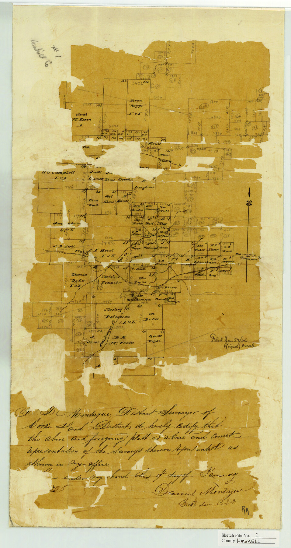
Haskell County Sketch File 1
[Sketch of surveys east from Haskell]
-
Map/Doc
11738
-
Collection
General Map Collection
-
Object Dates
1/9/1856 (Creation Date)
1/24/1856 (File Date)
-
People and Organizations
Daniel Montague (Surveyor/Engineer)
-
Counties
Haskell
-
Subjects
Surveying Sketch File
-
Height x Width
19.9 x 10.6 inches
50.6 x 26.9 cm
-
Medium
paper, manuscript
-
Features
California Creek
Part of: General Map Collection
Cooke County Sketch File 36

Print $4.00
- Digital $50.00
Cooke County Sketch File 36
1881
Size 7.8 x 8.4 inches
Map/Doc 19304
Brewster County Rolled Sketch 117

Print $20.00
- Digital $50.00
Brewster County Rolled Sketch 117
Size 21.1 x 28.6 inches
Map/Doc 5294
Harris County Rolled Sketch 31

Print $40.00
- Digital $50.00
Harris County Rolled Sketch 31
1893
Size 63.5 x 40.0 inches
Map/Doc 9111
Jefferson County Rolled Sketch 21

Print $20.00
- Digital $50.00
Jefferson County Rolled Sketch 21
Size 12.6 x 12.1 inches
Map/Doc 6386
Map of the United States and Mexico showing the Trans-Union and Tehuantepec route between Europe and Asia

Print $20.00
- Digital $50.00
Map of the United States and Mexico showing the Trans-Union and Tehuantepec route between Europe and Asia
1851
Size 20.3 x 23.7 inches
Map/Doc 94851
Map of Trinity County Texas

Print $20.00
- Digital $50.00
Map of Trinity County Texas
1859
Size 21.5 x 30.6 inches
Map/Doc 4095
Nueces County Sketch File 6

Print $20.00
- Digital $50.00
Nueces County Sketch File 6
Size 15.0 x 22.2 inches
Map/Doc 42175
Gonzales County

Print $40.00
- Digital $50.00
Gonzales County
1986
Size 41.6 x 54.7 inches
Map/Doc 73160
Upshur County Sketch File 15

Print $20.00
- Digital $50.00
Upshur County Sketch File 15
1934
Size 20.7 x 31.2 inches
Map/Doc 12505
Harris County Working Sketch 104

Print $20.00
- Digital $50.00
Harris County Working Sketch 104
1980
Size 17.2 x 10.3 inches
Map/Doc 65996
Parker County Sketch File 17

Print $6.00
- Digital $50.00
Parker County Sketch File 17
Size 10.7 x 9.5 inches
Map/Doc 33552
Flight Mission No. BRA-7M, Frame 83, Jefferson County

Print $20.00
- Digital $50.00
Flight Mission No. BRA-7M, Frame 83, Jefferson County
1953
Size 16.1 x 16.1 inches
Map/Doc 85505
You may also like
Karnes County Sketch File 12

Print $14.00
- Digital $50.00
Karnes County Sketch File 12
1889
Size 12.7 x 8.0 inches
Map/Doc 28604
Tyler County Rolled Sketch 10

Print $40.00
- Digital $50.00
Tyler County Rolled Sketch 10
1982
Size 48.7 x 35.4 inches
Map/Doc 10032
Flight Mission No. DQN-7K, Frame 37, Calhoun County

Print $20.00
- Digital $50.00
Flight Mission No. DQN-7K, Frame 37, Calhoun County
1953
Size 18.4 x 22.1 inches
Map/Doc 84475
Right of Way and Track Map International & Gt. Northern Ry. operated by the International & Gt. Northern Ry. Co., Gulf Division, Columbia Branch

Print $40.00
- Digital $50.00
Right of Way and Track Map International & Gt. Northern Ry. operated by the International & Gt. Northern Ry. Co., Gulf Division, Columbia Branch
1917
Size 25.1 x 57.0 inches
Map/Doc 64600
Map of Stephens County, Texas

Print $20.00
- Digital $50.00
Map of Stephens County, Texas
Size 36.8 x 40.1 inches
Map/Doc 93026
Fisher County Sketch File 17

Print $6.00
- Digital $50.00
Fisher County Sketch File 17
Size 11.0 x 12.5 inches
Map/Doc 22587
Map of Shackelford County

Print $20.00
- Digital $50.00
Map of Shackelford County
1901
Size 26.5 x 21.9 inches
Map/Doc 63031
Kerr County Sketch File 12

Print $4.00
- Digital $50.00
Kerr County Sketch File 12
1901
Size 6.7 x 11.1 inches
Map/Doc 28881
General Highway Map, Freestone County, Texas

Print $20.00
General Highway Map, Freestone County, Texas
1940
Size 18.6 x 25.1 inches
Map/Doc 79094
The Military History of Texas Map!

The Military History of Texas Map!
Size 24.2 x 35.2 inches
Map/Doc 94360
Map showing eight tidal areas in Oso Bay and Oso Creek, Nueces County, Texas offered for Mineral Development

Print $20.00
- Digital $50.00
Map showing eight tidal areas in Oso Bay and Oso Creek, Nueces County, Texas offered for Mineral Development
1936
Size 17.9 x 29.7 inches
Map/Doc 2067
Childress County Sketch File 20

Print $4.00
- Digital $50.00
Childress County Sketch File 20
1895
Size 12.7 x 8.2 inches
Map/Doc 18296