Parker County Sketch File 17
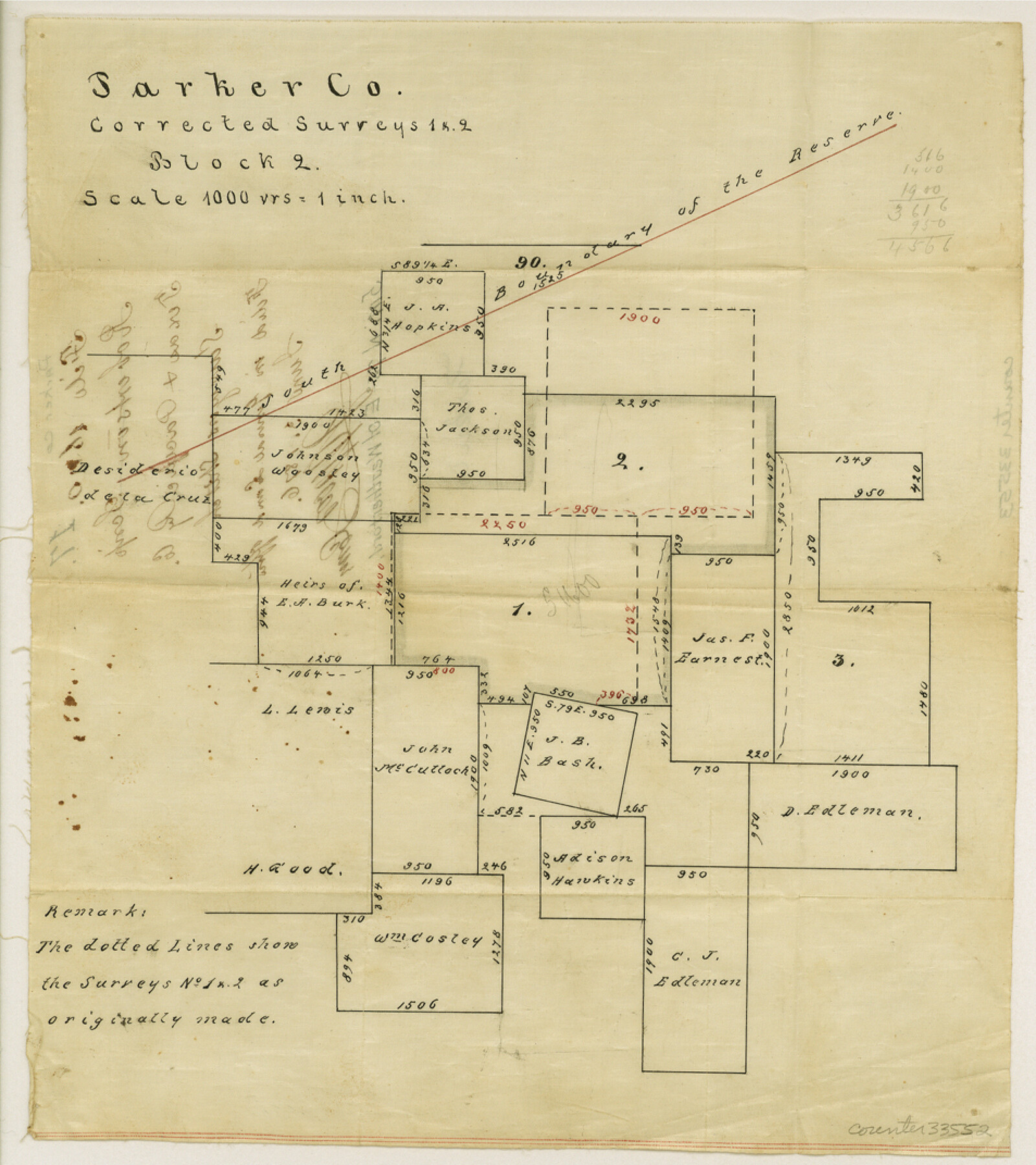
[Sketch of corrected surveys 1 and 2 in Block 2, T. & P. RR. Co.]
-
Map/Doc
33552
-
Collection
General Map Collection
-
Object Dates
6/3/1876 (File Date)
-
Counties
Parker
-
Subjects
Surveying Sketch File
-
Height x Width
10.7 x 9.5 inches
27.2 x 24.1 cm
-
Medium
paper, manuscript
-
Scale
1" = 1000 varas
Part of: General Map Collection
Henderson County Working Sketch 36

Print $20.00
- Digital $50.00
Henderson County Working Sketch 36
1973
Size 27.5 x 19.0 inches
Map/Doc 66169
Flight Mission No. DQN-1K, Frame 116, Calhoun County

Print $20.00
- Digital $50.00
Flight Mission No. DQN-1K, Frame 116, Calhoun County
1953
Size 18.7 x 22.4 inches
Map/Doc 84182
Throckmorton County Sketch File 5

Print $58.00
- Digital $50.00
Throckmorton County Sketch File 5
Size 14.4 x 8.7 inches
Map/Doc 38056
Mitchell County Sketch File 12

Print $20.00
- Digital $50.00
Mitchell County Sketch File 12
1912
Size 25.6 x 14.0 inches
Map/Doc 12099
Crosby County Boundary File 1

Print $20.00
- Digital $50.00
Crosby County Boundary File 1
Size 7.4 x 4.1 inches
Map/Doc 51971
Menard County Boundary File 9

Print $4.00
- Digital $50.00
Menard County Boundary File 9
Size 9.9 x 8.1 inches
Map/Doc 57094
McLennan County Boundary File 4a

Print $8.00
- Digital $50.00
McLennan County Boundary File 4a
Size 14.1 x 8.6 inches
Map/Doc 56979
Flight Mission No. BRA-16M, Frame 85, Jefferson County

Print $20.00
- Digital $50.00
Flight Mission No. BRA-16M, Frame 85, Jefferson County
1953
Size 18.6 x 22.4 inches
Map/Doc 85697
Presidio County Sketch File 27 1/2

Print $6.00
- Digital $50.00
Presidio County Sketch File 27 1/2
1890
Size 11.0 x 13.5 inches
Map/Doc 34466
Hamilton County Sketch File 6

Print $6.00
- Digital $50.00
Hamilton County Sketch File 6
Size 15.7 x 10.6 inches
Map/Doc 24910
Harbor of Brazos Santiago, Texas

Print $20.00
- Digital $50.00
Harbor of Brazos Santiago, Texas
1887
Size 27.1 x 18.3 inches
Map/Doc 72998
Reeves County Rolled Sketch 31

Print $20.00
- Digital $50.00
Reeves County Rolled Sketch 31
Size 21.7 x 27.9 inches
Map/Doc 7500
You may also like
Jack County Sketch File 19

Print $4.00
- Digital $50.00
Jack County Sketch File 19
1878
Size 10.4 x 8.3 inches
Map/Doc 27559
Carte du Canada et de la Louisiane qui forment la Nouvelle France et des colonies angloises ou sont representez les pays contestez

Print $20.00
- Digital $50.00
Carte du Canada et de la Louisiane qui forment la Nouvelle France et des colonies angloises ou sont representez les pays contestez
1756
Size 21.5 x 29.6 inches
Map/Doc 97415
Rio Grande, Raymondville Sheet

Print $20.00
- Digital $50.00
Rio Grande, Raymondville Sheet
1937
Size 37.3 x 37.9 inches
Map/Doc 65110
Castro County Sketch File 4b

Print $4.00
- Digital $50.00
Castro County Sketch File 4b
Size 13.5 x 8.9 inches
Map/Doc 17467
Young County Working Sketch 2

Print $20.00
- Digital $50.00
Young County Working Sketch 2
1918
Size 28.1 x 33.7 inches
Map/Doc 62025
[University Lands Blocks 16-18]
![91568, [University Lands Blocks 16-18], Twichell Survey Records](https://historictexasmaps.com/wmedia_w700/maps/91568-1.tif.jpg)
Print $20.00
- Digital $50.00
[University Lands Blocks 16-18]
Size 18.5 x 12.7 inches
Map/Doc 91568
Maps of Gulf Intracoastal Waterway, Texas - Sabine River to the Rio Grande and connecting waterways including ship channels

Print $20.00
- Digital $50.00
Maps of Gulf Intracoastal Waterway, Texas - Sabine River to the Rio Grande and connecting waterways including ship channels
1966
Size 14.6 x 22.2 inches
Map/Doc 61946

Cass County Working Sketch 55

Print $20.00
- Digital $50.00
Cass County Working Sketch 55
2013
Size 17.3 x 20.6 inches
Map/Doc 93415
Eastland County Sketch File 20

Print $62.00
- Digital $50.00
Eastland County Sketch File 20
1987
Size 9.1 x 11.3 inches
Map/Doc 21609
McMullen County Working Sketch 7

Print $20.00
- Digital $50.00
McMullen County Working Sketch 7
1926
Size 20.7 x 17.5 inches
Map/Doc 70708
San Jacinto River, Buff Lake Sheet 1/Caney Creek

Print $20.00
- Digital $50.00
San Jacinto River, Buff Lake Sheet 1/Caney Creek
1937
Size 18.7 x 37.6 inches
Map/Doc 65147