Presidio County Sketch File 28
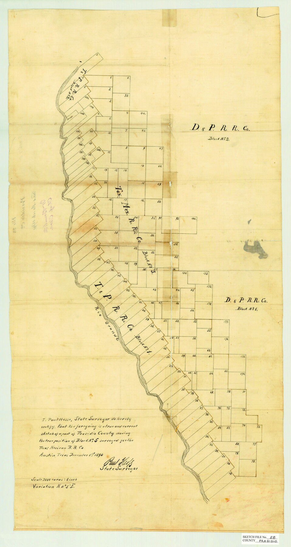
[Sketch showing true position of Tex. Mex. R.R. Co. Block 5, Presidio County, Texas]
-
Map/Doc
11709
-
Collection
General Map Collection
-
Object Dates
12/1/1890 (Creation Date)
3/15/1891 (File Date)
-
People and Organizations
Paul Hesse (Surveyor/Engineer)
-
Counties
Presidio
-
Subjects
Surveying Sketch File
-
Height x Width
30.2 x 16.1 inches
76.7 x 40.9 cm
-
Medium
paper, manuscript
-
Scale
1" = 2000 varas
-
Comments
See Presidio County Rolled Sketch 100 (7382) for related sketch.
-
Features
Rio Grande
Related maps
Presidio County Rolled Sketch 100

Print $20.00
- Digital $50.00
Presidio County Rolled Sketch 100
1954
Size 30.4 x 30.2 inches
Map/Doc 7382
Part of: General Map Collection
Jeff Davis County Working Sketch 44

Print $20.00
- Digital $50.00
Jeff Davis County Working Sketch 44
1984
Size 28.8 x 37.4 inches
Map/Doc 66539
East Part of Jeff Davis Co.

Print $20.00
- Digital $50.00
East Part of Jeff Davis Co.
1977
Size 40.6 x 30.9 inches
Map/Doc 77327
Crockett County Working Sketch 87

Print $20.00
- Digital $50.00
Crockett County Working Sketch 87
1976
Size 35.5 x 43.8 inches
Map/Doc 68420
Flight Mission No. DAG-28K, Frame 23, Matagorda County

Print $20.00
- Digital $50.00
Flight Mission No. DAG-28K, Frame 23, Matagorda County
1953
Size 18.6 x 22.5 inches
Map/Doc 86591
Edwards County Working Sketch 13

Print $20.00
- Digital $50.00
Edwards County Working Sketch 13
1922
Size 18.3 x 18.4 inches
Map/Doc 68889
Morris County Rolled Sketch 2A

Print $20.00
- Digital $50.00
Morris County Rolled Sketch 2A
Size 24.0 x 18.8 inches
Map/Doc 10273
Sulphur River, Talco Sheet

Print $20.00
- Digital $50.00
Sulphur River, Talco Sheet
1917
Size 24.6 x 43.7 inches
Map/Doc 65160
Duval County Working Sketch 40

Print $20.00
- Digital $50.00
Duval County Working Sketch 40
1960
Size 19.5 x 16.6 inches
Map/Doc 68764
Kimble County Rolled Sketch 35

Print $20.00
- Digital $50.00
Kimble County Rolled Sketch 35
1978
Size 20.0 x 19.6 inches
Map/Doc 6525
Hardin County Rolled Sketch WS

Print $20.00
- Digital $50.00
Hardin County Rolled Sketch WS
1936
Size 25.4 x 43.9 inches
Map/Doc 9104
Map of section no. 12 of a survey of Padre Island made for the Office of the Attorney General of the State of Texas

Print $40.00
- Digital $50.00
Map of section no. 12 of a survey of Padre Island made for the Office of the Attorney General of the State of Texas
1941
Size 75.9 x 41.0 inches
Map/Doc 2268
Leon County Rolled Sketch 26A

Print $20.00
- Digital $50.00
Leon County Rolled Sketch 26A
1988
Size 21.5 x 34.4 inches
Map/Doc 6611
You may also like

McMullen County Rolled Sketch 22

Print $20.00
- Digital $50.00
McMullen County Rolled Sketch 22
2004
Size 15.3 x 24.6 inches
Map/Doc 88824
Atascosa County Working Sketch Graphic Index

Print $20.00
- Digital $50.00
Atascosa County Working Sketch Graphic Index
1948
Size 46.1 x 42.8 inches
Map/Doc 76458
[Right of Way & Track Map, The Texas & Pacific Ry. Co. Main Line]
![64662, [Right of Way & Track Map, The Texas & Pacific Ry. Co. Main Line], General Map Collection](https://historictexasmaps.com/wmedia_w700/maps/64662.tif.jpg)
Print $20.00
- Digital $50.00
[Right of Way & Track Map, The Texas & Pacific Ry. Co. Main Line]
Size 11.0 x 18.5 inches
Map/Doc 64662
University Land Field Notes for Blocks 1, 2, 3, 4, 5, 8, 9, and 10 in Andrews County, Block 6 in Andrews, Dawson, Gaines, and Martin Counties, and Block 7 in Andrews and Martin Counties

University Land Field Notes for Blocks 1, 2, 3, 4, 5, 8, 9, and 10 in Andrews County, Block 6 in Andrews, Dawson, Gaines, and Martin Counties, and Block 7 in Andrews and Martin Counties
Map/Doc 81710
Sutton County Working Sketch 61

Print $20.00
- Digital $50.00
Sutton County Working Sketch 61
1959
Size 44.1 x 38.6 inches
Map/Doc 62404
General Highway Map, Harrison County, Texas

Print $20.00
General Highway Map, Harrison County, Texas
1940
Size 18.2 x 24.8 inches
Map/Doc 79121
Concho, San Saba & Llano Valley Railway, Sterling City Branch, Texas. Right of Way and Track Map

Print $40.00
- Digital $50.00
Concho, San Saba & Llano Valley Railway, Sterling City Branch, Texas. Right of Way and Track Map
1910
Size 18.1 x 121.2 inches
Map/Doc 64438
[Geological Map of Texas]
![62962, [Geological Map of Texas], General Map Collection](https://historictexasmaps.com/wmedia_w700/maps/62962.tif.jpg)
Print $20.00
- Digital $50.00
[Geological Map of Texas]
Size 17.6 x 18.1 inches
Map/Doc 62962
Hood County Rolled Sketch 2

Print $20.00
- Digital $50.00
Hood County Rolled Sketch 2
1958
Size 18.0 x 27.4 inches
Map/Doc 6219
Right of Way and Track Map of The Missouri, Kansas & Texas Railway of Texas

Print $40.00
- Digital $50.00
Right of Way and Track Map of The Missouri, Kansas & Texas Railway of Texas
1918
Size 25.0 x 50.7 inches
Map/Doc 64536
Flight Mission No. DAG-28K, Frame 32, Matagorda County

Print $20.00
- Digital $50.00
Flight Mission No. DAG-28K, Frame 32, Matagorda County
1953
Size 16.2 x 16.0 inches
Map/Doc 86600