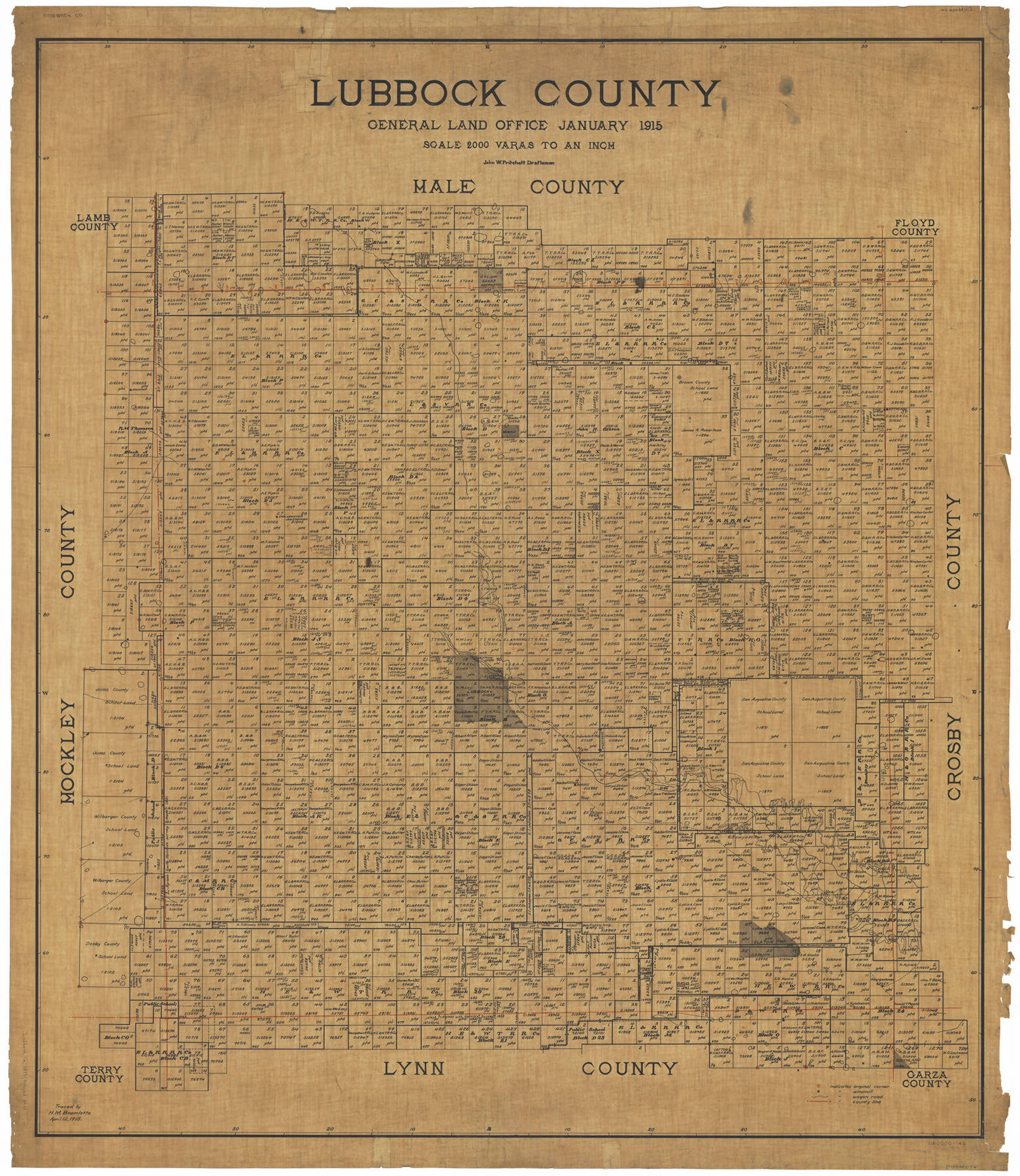
Lubbock County
-
Map/Doc
66911
-
Collection
General Map Collection
-
Object Dates
1915 (Creation Date)
-
People and Organizations
Texas General Land Office (Publisher)
John W. Pritchett (Draftsman)
John W. Pritchett (Compiler)
-
Counties
Lubbock
-
Subjects
County
-
Height x Width
46.1 x 40.0 inches
117.1 x 101.6 cm
-
Comments
Traced April 12, 1915 by H. M. Bramlette.
Part of: General Map Collection
Nueces County Rolled Sketch 121

Print $32.00
Nueces County Rolled Sketch 121
1994
Size 18.2 x 24.5 inches
Map/Doc 7152
Cooke County Boundary File 1a

Print $32.00
- Digital $50.00
Cooke County Boundary File 1a
Size 12.6 x 7.5 inches
Map/Doc 51828
Right of Way and Track Map Texas & New Orleans R.R. Co. operated by the T. & N. O. R.R. Co. Dallas-Sabine Branch

Print $40.00
- Digital $50.00
Right of Way and Track Map Texas & New Orleans R.R. Co. operated by the T. & N. O. R.R. Co. Dallas-Sabine Branch
1918
Size 26.4 x 56.7 inches
Map/Doc 64154
Hardin County Sketch File 71f

Print $20.00
- Digital $50.00
Hardin County Sketch File 71f
1997
Size 25.2 x 36.7 inches
Map/Doc 11643
Terry County Sketch File 13

Print $20.00
- Digital $50.00
Terry County Sketch File 13
Size 43.2 x 10.2 inches
Map/Doc 10397
Flight Mission No. CLL-1N, Frame 40, Willacy County

Print $20.00
- Digital $50.00
Flight Mission No. CLL-1N, Frame 40, Willacy County
1954
Size 18.5 x 22.2 inches
Map/Doc 87021
Rio Grande, Willamar Sheet

Print $20.00
- Digital $50.00
Rio Grande, Willamar Sheet
1937
Size 36.9 x 37.2 inches
Map/Doc 65111
Terrell County Working Sketch 6

Print $20.00
- Digital $50.00
Terrell County Working Sketch 6
1914
Size 15.7 x 21.9 inches
Map/Doc 62155
Dickens County

Print $20.00
- Digital $50.00
Dickens County
1915
Size 42.2 x 39.0 inches
Map/Doc 66805
Hamilton County Working Sketch 28

Print $20.00
- Digital $50.00
Hamilton County Working Sketch 28
1976
Size 27.7 x 33.2 inches
Map/Doc 63366
Trinity County Sketch File 38

Print $8.00
- Digital $50.00
Trinity County Sketch File 38
1948
Size 14.5 x 8.9 inches
Map/Doc 38593
Sutton County Working Sketch 56

Print $20.00
- Digital $50.00
Sutton County Working Sketch 56
1958
Size 27.6 x 28.8 inches
Map/Doc 62399
You may also like
Hardin County Working Sketch 14

Print $20.00
- Digital $50.00
Hardin County Working Sketch 14
1936
Size 25.1 x 42.6 inches
Map/Doc 63412
Potter County Boundary File 5b

Print $22.00
- Digital $50.00
Potter County Boundary File 5b
Size 4.1 x 4.9 inches
Map/Doc 58025
Kendall County

Print $20.00
- Digital $50.00
Kendall County
1946
Size 41.6 x 35.9 inches
Map/Doc 1872
Bee County Sketch File 5

Print $40.00
- Digital $50.00
Bee County Sketch File 5
Size 27.4 x 23.4 inches
Map/Doc 10914
Matagorda County Aerial Photograph Index Sheet 4

Print $20.00
- Digital $50.00
Matagorda County Aerial Photograph Index Sheet 4
1953
Size 23.6 x 19.5 inches
Map/Doc 83725
Flight Mission No. DQN-2K, Frame 195, Calhoun County

Print $20.00
- Digital $50.00
Flight Mission No. DQN-2K, Frame 195, Calhoun County
1953
Size 18.6 x 22.2 inches
Map/Doc 84333
[Sketch showing PSL Blocks A13, A25-A27, A30-A32, A37, A38, A47-A49 & N/L Univ. Blk. 11]
![89738, [Sketch showing PSL Blocks A13, A25-A27, A30-A32, A37, A38, A47-A49 & N/L Univ. Blk. 11], Twichell Survey Records](https://historictexasmaps.com/wmedia_w700/maps/89738-1.tif.jpg)
Print $40.00
- Digital $50.00
[Sketch showing PSL Blocks A13, A25-A27, A30-A32, A37, A38, A47-A49 & N/L Univ. Blk. 11]
Size 23.6 x 62.4 inches
Map/Doc 89738
Flight Mission No. BRA-16M, Frame 128, Jefferson County

Print $20.00
- Digital $50.00
Flight Mission No. BRA-16M, Frame 128, Jefferson County
1953
Size 18.6 x 22.7 inches
Map/Doc 85738
Irion County Sketch File 18

Print $10.00
- Digital $50.00
Irion County Sketch File 18
Size 11.2 x 8.7 inches
Map/Doc 27494
Hale County Sketch File 10

Print $6.00
- Digital $50.00
Hale County Sketch File 10
1895
Size 16.3 x 9.4 inches
Map/Doc 24737
Presidio County Rolled Sketch 102

Print $20.00
- Digital $50.00
Presidio County Rolled Sketch 102
1957
Size 19.3 x 13.8 inches
Map/Doc 7385
[Travis District]
![88740, [Travis District], General Map Collection](https://historictexasmaps.com/wmedia_w700/maps/88740.tif.jpg)
Print $40.00
- Digital $50.00
[Travis District]
1840
Size 54.7 x 46.0 inches
Map/Doc 88740