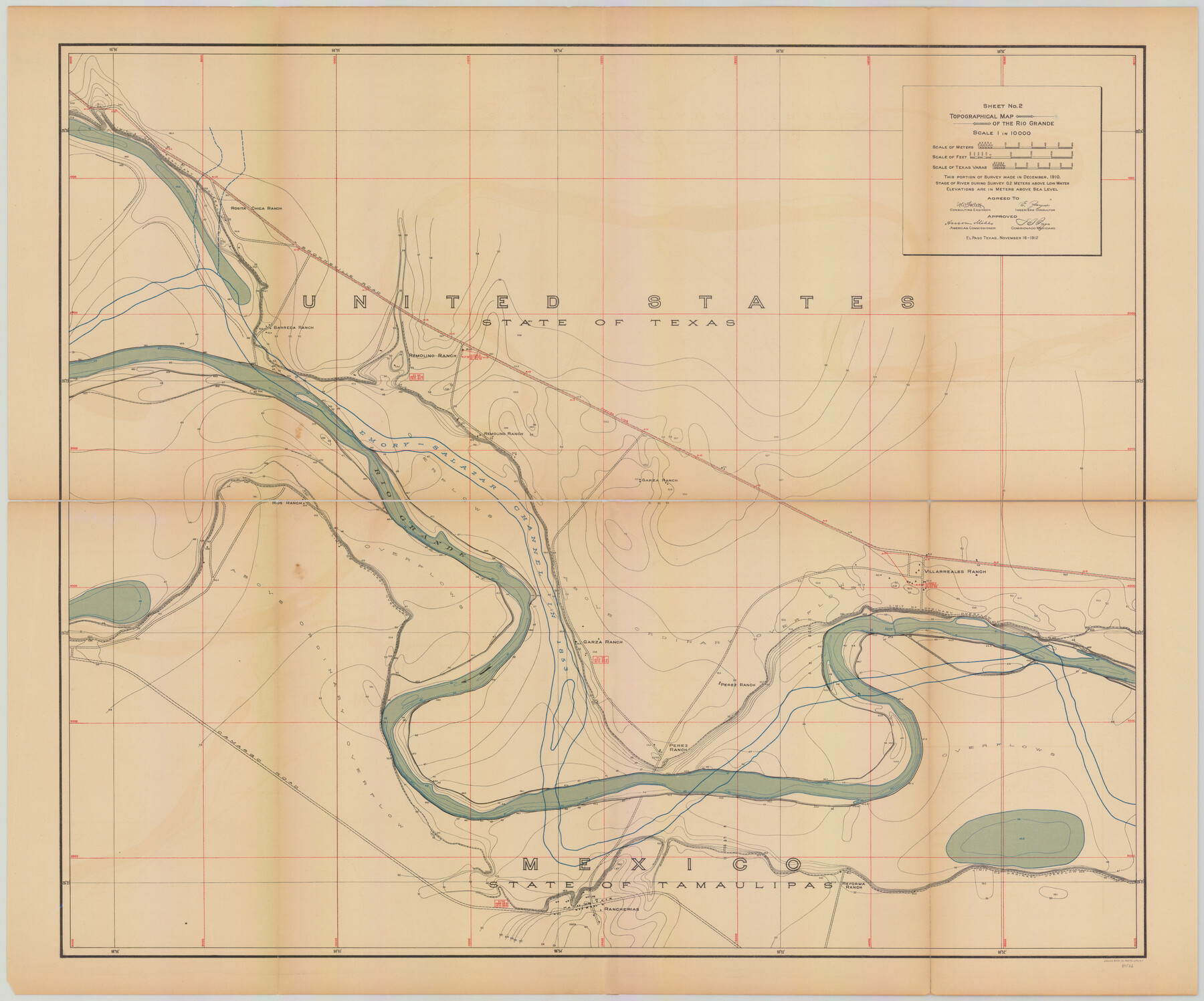
Topographical Map of the Rio Grande, Sheet No. 2
[from book: "Survey of the Rio Grande, Roma to the Gulf of Mexico, Reports and Maps"]
-
Map/Doc
89526
-
Collection
General Map Collection
-
Object Dates
1912/11/16 (Creation Date)
-
People and Organizations
International Boundary Commission (Publisher)
Anson Mills (Author)
E. Zayas (Surveyor/Engineer)
F.B. Puga (Author)
W.W. Follett (Surveyor/Engineer)
-
Subjects
River Surveys Texas Boundaries Topographic
-
Medium
paper
-
Scale
1:10000
-
Comments
This portion of the survey made in December 1910. State of river during survey 0.2 meters above low water. Elevations are in meters above sea level. This map and 31 others were originally folded and bound into a book titled "Survey of the Rio Grande,
Part of: General Map Collection
Chambers County Working Sketch 12

Print $20.00
- Digital $50.00
Chambers County Working Sketch 12
1954
Size 35.2 x 33.8 inches
Map/Doc 67995
Schleicher County Sketch File 15

Print $22.00
- Digital $50.00
Schleicher County Sketch File 15
1928
Size 8.1 x 12.9 inches
Map/Doc 36504

Lavaca County Working Sketch 9

Print $20.00
- Digital $50.00
Lavaca County Working Sketch 9
1949
Size 24.7 x 33.9 inches
Map/Doc 70362
[Sketch for Mineral Application 16787 - Pecos River Bed, A. T. Freet]
![65632, [Sketch for Mineral Application 16787 - Pecos River Bed, A. T. Freet], General Map Collection](https://historictexasmaps.com/wmedia_w700/maps/65632-1.tif.jpg)
Print $40.00
- Digital $50.00
[Sketch for Mineral Application 16787 - Pecos River Bed, A. T. Freet]
Size 70.8 x 18.9 inches
Map/Doc 65632
Dickens County Sketch File 36

Print $4.00
- Digital $50.00
Dickens County Sketch File 36
1891
Size 11.3 x 9.1 inches
Map/Doc 21042
Hood County Working Sketch 25

Print $20.00
- Digital $50.00
Hood County Working Sketch 25
1995
Size 25.8 x 37.7 inches
Map/Doc 66219
San Augustine County Working Sketch 6

Print $20.00
- Digital $50.00
San Augustine County Working Sketch 6
1935
Size 22.2 x 37.9 inches
Map/Doc 63693
Pecos County Sketch File 18

Print $32.00
- Digital $50.00
Pecos County Sketch File 18
1884
Size 24.5 x 9.6 inches
Map/Doc 12159
Gregg County Sketch File 16

Print $6.00
- Digital $50.00
Gregg County Sketch File 16
1931
Size 17.0 x 11.0 inches
Map/Doc 24619
Terrell County Working Sketch 52

Print $40.00
- Digital $50.00
Terrell County Working Sketch 52
1958
Size 49.2 x 42.5 inches
Map/Doc 62145
[Map] of Goliad Land District
![3586, [Map] of Goliad Land District, General Map Collection](https://historictexasmaps.com/wmedia_w700/maps/3586-1.tif.jpg)
Print $20.00
- Digital $50.00
[Map] of Goliad Land District
1856
Size 33.5 x 25.2 inches
Map/Doc 3586
You may also like
Houston County Working Sketch 27

Print $20.00
- Digital $50.00
Houston County Working Sketch 27
1988
Size 34.9 x 28.5 inches
Map/Doc 66257
Cottle County Rolled Sketch 12

Print $20.00
- Digital $50.00
Cottle County Rolled Sketch 12
1963
Size 34.2 x 25.7 inches
Map/Doc 5549
Brazoria County Rolled Sketch 41

Print $20.00
- Digital $50.00
Brazoria County Rolled Sketch 41
Size 30.3 x 21.3 inches
Map/Doc 5176
Schleicher County Sketch File 40

Print $6.00
- Digital $50.00
Schleicher County Sketch File 40
1958
Size 11.2 x 8.9 inches
Map/Doc 36541
Howard County Rolled Sketch 10A

Print $20.00
- Digital $50.00
Howard County Rolled Sketch 10A
1940
Size 19.9 x 20.4 inches
Map/Doc 6241
Schleicher County

Print $40.00
- Digital $50.00
Schleicher County
1940
Size 39.7 x 55.9 inches
Map/Doc 95636
General Highway Map. Detail of Cities and Towns in Potter County, Texas [Amarillo and vicinity]
![79221, General Highway Map. Detail of Cities and Towns in Potter County, Texas [Amarillo and vicinity], Texas State Library and Archives](https://historictexasmaps.com/wmedia_w700/maps/79221.tif.jpg)
Print $20.00
General Highway Map. Detail of Cities and Towns in Potter County, Texas [Amarillo and vicinity]
1940
Size 24.6 x 18.2 inches
Map/Doc 79221
Pecos County Rolled Sketch 156

Print $40.00
- Digital $50.00
Pecos County Rolled Sketch 156
1938
Size 39.7 x 48.1 inches
Map/Doc 9738
Map of Anderson County, Texas

Print $20.00
- Digital $50.00
Map of Anderson County, Texas
1879
Size 18.5 x 21.7 inches
Map/Doc 377
Jeff Davis County Rolled Sketch 16

Print $20.00
- Digital $50.00
Jeff Davis County Rolled Sketch 16
Size 27.1 x 31.7 inches
Map/Doc 6369
Travels to the source of the Missouri River and across the American Continent to the Pacific Ocean - Vol. 3

Travels to the source of the Missouri River and across the American Continent to the Pacific Ocean - Vol. 3
1815
Map/Doc 97414
Ochiltree County Sketch File 7

Print $20.00
- Digital $50.00
Ochiltree County Sketch File 7
Size 14.5 x 26.1 inches
Map/Doc 42204